Download PDF
Download page FEMA's Future of Flood Risk Data Initiative.
FEMA's Future of Flood Risk Data Initiative
By: William Lehman
Introduction
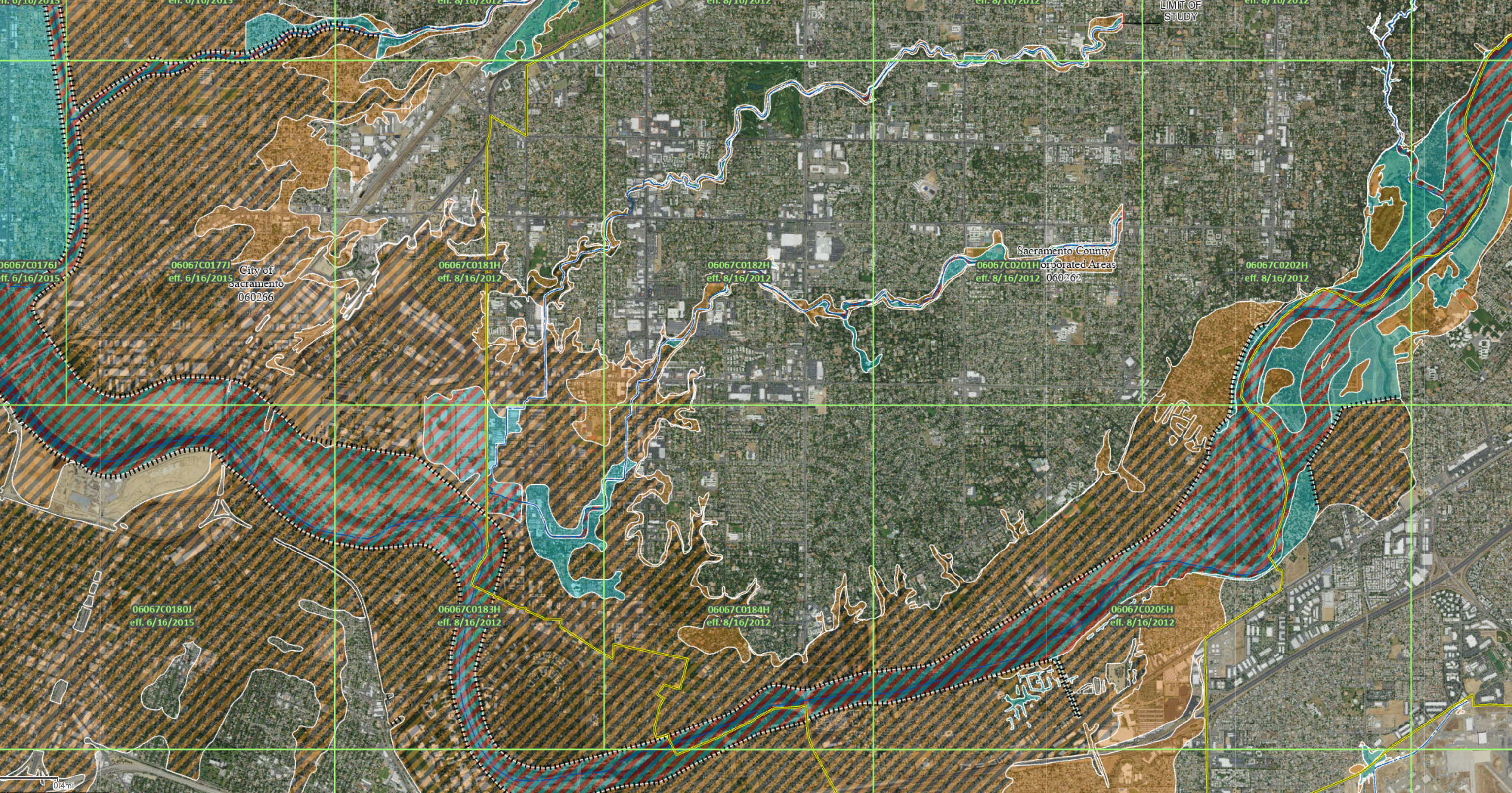
The Federal Emergency Management Agency (FEMA) has produced Flood Insurance Rate Maps (FIRMs) for use in defining regulatory floodplains for the last 60 years. These floodplain maps were designed to support floodplain management, regulation, mandatory purchase of flood insurance, and flood insurance rate setting. However, they have been used for a broader scope than their original intent through public perception that the maps relay areas prone to flooding and areas that will not flood. This perception is an inappropriate use of the maps, but in the absence of clear nationally available data describing areas of flooding and their recurrence intervals, the maps are used in the place of a truer representation of our nation's exposure to flooding. An example of a traditional FEMA FIRM is shown in Figure 1.
The Biggert-Waters Flood Insurance Reform Act of 2012 (BW12) sought to improve floodplain management deliverables from FEMA in the following ways:
- Map flood hazard to at least the 500 year
- Map all areas of current population
- Map all areas of potential future population
- Include residual risk from potential dam or levee failures
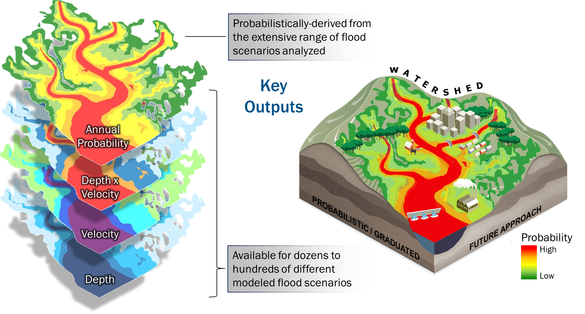
In addition to the BW12 requirements, multiple reports from stakeholder organizations (e.g. Technical Mapping Advisory Council, National Academy of Sciences, Association of State Floodplain Mangers) have recommended improvements in FEMA's regulatory and non-regulatory floodplain-related products. The non-regulatory products are beneficial to the public in support of floodplain management and planning because they include maps of flooding more frequent than the 100 year and less frequent than the 100 year providing a better understanding of the hazard frequency of a floodplain. However, non-regulatory products are not currently available for the entire United States. FEMA's Future of Flood Risk Data (FFRD) Initiative seeks to fill the gap in coverage for non-regulatory products, with the goals of increasing flood risk awareness, meeting the statutory requirements of BW12, and empowering risk-informed decision-making at all levels of government as well as by private individuals and organizations (Figure 2).
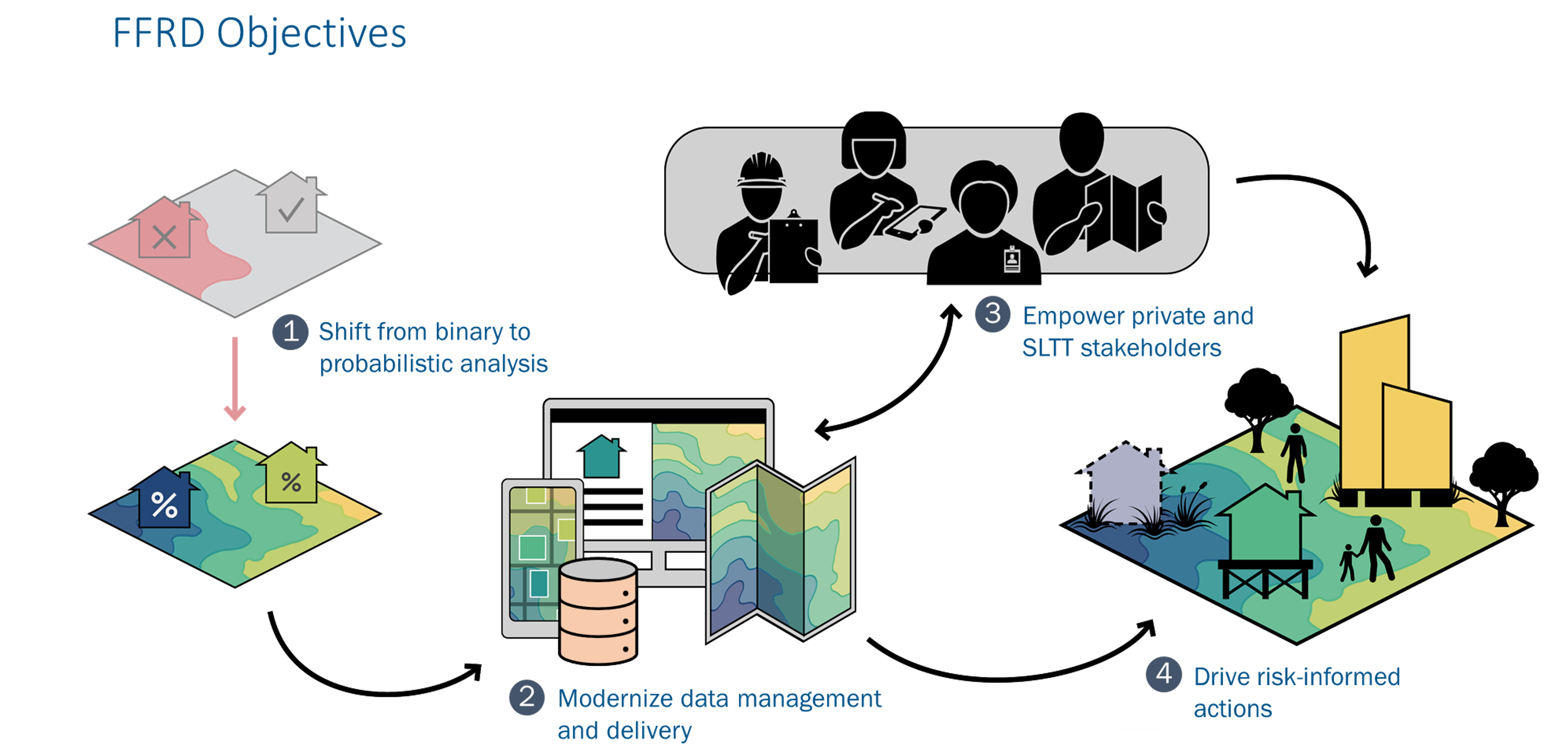
USACE is in Year 2 of a 4-year Interagency Reimbursable Work Agreement (IRWA) to support FEMA in meeting two primary objectives within the FFRD initiative: 1) shift from binary to probabilistic analysis and 2) modernization of data management and delivery, as seen in the image above. The work is governed by a Steering Committee composed of USACE and FEMA members, drawn from USACE's Headquarters, Risk Management Center, Modeling, Mapping and Consequences Center, and the Hydrologic Engineering Center, and FEMA's Risk Management Directorate. The working team includes USACE and FEMA staff as well as FEMA Production and Technical Services (PTS) contractors, and includes district and regional staff, headquarters staff from both organizations and subject matter experts from HEC, RMC, and the MMC across multiple disciplines.
The team is working on a methodology to shift from binary 100-year floodplains to probabilistic methods that produce graduated floodplains from approximately the 5-year to the 2000-year. This methodology is being tested and refined in three ongoing pilot projects across the nation and being documented in Standard Operating Procedures to ensure consistency in the development and computation of models across the nation.
Shift from Binary to Probabilistic Analysis
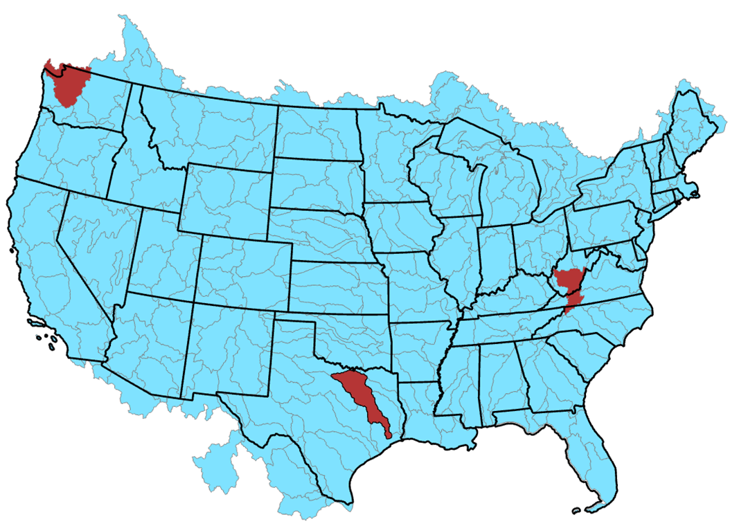
The USACE FFRD Technical team is working together with FEMA's PTS contractors and FEMA Headquarters staff to develop the appropriate methodology to shift from binary to probabilistic analysis of floodplains. Three pilot projects are currently in progress or planned to help address specific issues in a national probabilistic analysis with sufficient quality to drive risk-informed actions. Figure 3, illustrates the locations of these three projects: the Duwamish Hydrologic Unit Code (HUC) 8 basin containing the Green River is located in Washington, the Trinity River is located in Texas, and the Kanawha River is located in West Virginia and Virginia.
The FFRD methodology must address the heterogeneity of data availability and the hydrologic, hydraulic, flood management systems, and consequences across our nation. When data gaps are identified, the FFRD initiative seeks to find the appropriate authoritative federal agency with the appropriate authoritative data to fill those data gaps. For example, the United States Geological Survey (USGS) is the authoritative data source for streamflow gage data across our nation. However, the density of the network is insufficient to support the hydrology data requirements, so the team identified that the methodology must start with precipitation isohyets provided by National Oceanic and Atmospheric Administration (NOAA) through datasets like the Analysis of Record for Calibration (AORC) data. Learn more about how FFRD is leveraging Stochastic Storm Transposition in "Stochastic Storm Transposition in HEC-HMS" newsletter article. The USGS's 3D Elevation Program (3DEP) terrain data supplies FFRD with the authoritative topographic elevation data and USACE's National Inventory of Dams and National Levee Database provide the authoritative data for dams and levees across the nation. Consequence assessments leverage USACE's National Structure Inventory (NSI) as the base data for structure locations, classifications, valuations, and population.
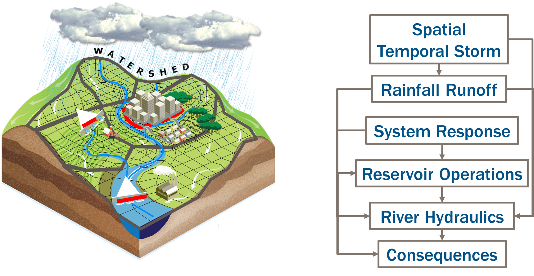
The FFRD team is pulling together these authoritative data sources to populate hydrologic, hydraulic, reservoir operations, and consequence models for every HUC 4 (Figure 3) watershed in the nation. These models will be linked together and run remotely in the cloud to achieve the scale necessary for a national rollout. The cloud-based modeling framework will use a programming tool called an Application Programming Interface (API) to define a Software Development Kit (SDK), implemented in multiple languages. This provides a communication pipeline between different software packages to coordinate input, output, and execution of the programs. Implementations of the SDK are called plugins, and can be used in the framework to accomplish tasks. The framework is designed to be agnostic to any specific software package or model; however, the default software in the SOP will be from the HEC suite of software: HEC-HMS, HEC-ResSim, and HEC-RAS. Since this modeling effort is collaborative with FEMA, the consequence modeling developed will satisfy both agencies requirements for decision making documents. In addition to these models, smaller plugins will be developed to support the FFRD workflow, such as collection of key outputs, generation of random number seeds, and sampling of fragility curves for levees and dams. A conceptual graphic of the modeling sequence is provided in Figure 4.
These linked models will be executed to produce probabilistic outcomes, as shown in Figure 5. The pilot studies are seeking to implement the SOP within the probabilistic framework, which uses a Monte Carlo analysis. The pilot studies are designed to test the SOP and to ensure that the outputs necessary to meet the BW12 requirements are provided. These outputs include hazard frequency curves with uncertainty for multiple parameters that help drive consequence assessments and risk drivers across the floodplain, and can build maps that convey hazard information. With the addition of consequence assessments in the workflow, risk calculations can be performed at structures throughout the watershed for metrics such as Expected Annual Damage with uncertainty for every structure in the nation.
Modernization of Data Management and Delivery
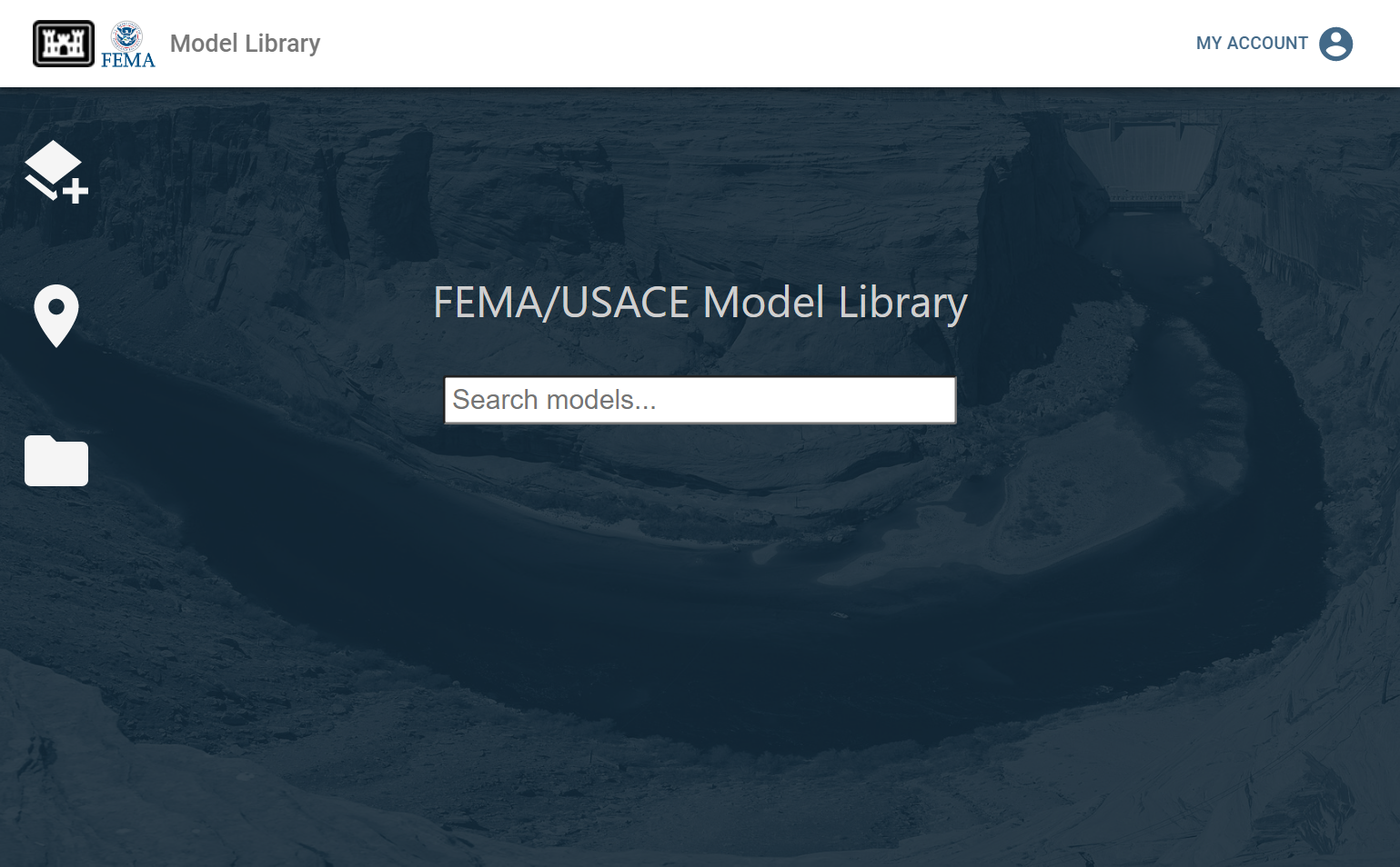
The FFRD initiative recognizes that the value of the models and data to drive the models are equally as important as the outputs and derived mapping products used for non-regulatory maps. Therefore, these models are being curated to support future usage of the models such as evaluating structural and nonstructural changes in the watershed to support comparison of flood risk management alternatives. FEMA and USACE have collaborated to build the FEMA/USACE Model Library, which is a joint federal indexing system that supports continued accessibility of the models used to generate FFRD outputs.
Model Library is a tool to connect multiple file stores to users and groups of users. Model Library uses Login.gov for authentication, which will allow multi agency access as well as public access to the models in Model Library (Figure 6). The use of Login.gov allows for the seamless transfer of data across agency borders. Model Library provides a system of indexing data (much like a card catalog in a library) in cloud storage systems like AWS S3 (Amazon Web Services Simple Storage System). Models are indexed through a system of analysis tools called Model Content Analysis Tools (MCATs), which evaluate the contents of the data store and attempt to identify the data as a model. This system is designed to simplify the discovery and access of models to the public, supporting the FAIR principles (Findable Accessible Interoperable Reusable).
Conclusion
USACE is supporting FEMA in the FFRD initiative. FEMA's vision for FFRD marks a substantial advancement in the data availability and analysis to support floodplain regulation, management, and risk communication. A tremendous amount of complex multi-agency teamwork is required, but the results will set the stage for an improved understanding of our nation's flood risk.
Last Modified: 2023-06-09 09:53:18.727