Download PDF
Download page Computing Subbasin and Reach Characteristics.
Computing Subbasin and Reach Characteristics
Last Modified: 2024-11-04 16:36:23.136
Software Version
HEC-HMS version 4.13 beta 3 was used to create this tutorial. You will need to use HEC-HMS version 4.13 beta 3, or newer, to open the project files.

Overview
This tutorial will guide you through the steps of computing subbasin and reach characteristics within HEC-HMS.
Compute Subbasin Characteristics
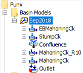
- Open the Punx.hms project.
- Select the Basin Model → Sep2018.
- Compute subbasin characteristics by selecting Parameters→ Characteristics→ Subbasin.

- HEC-HMS will calculate various characteristics for each subbasin in the basin model.

- Select the Basin Model → Sep2018.
- For a quick overview of each of the subbasin characteristics, see the Basin Characteristics page of the HEC-HMS Users Manual.
Compute Reach Characteristics
- In a similar fashion as above, compute reach characteristics for the Punx model.
- Select Parameters→ Characteristics→ Reach.

- HEC-HMS will calculate a few reach characteristics for each of the reaches in the basin model. In this simple model, there is only one reach.

- Select Parameters→ Characteristics→ Reach.
- For a quick overview of the above reach statistics, see the Basin Characteristics page of the HEC-HMS Users Manual.
Questions
When comparing the longest flowpath, centroidal flowpath, and 10-85 flowpath slopes, which slope is the steepest? Why might this be?
For most subbasins, the longest flowpath slope is typically the steepest. Since longest flowpaths extend from the subbasin outlet all the way to the subbasin divide, the higher elevations near the divide can result in a steeper computed slope that is not necessarily representative of the other portions of the flowpath. For this reason, the 10-85 slope is often more representative of the general flowpath slopes as seen throughout most of the subbasin.
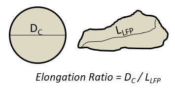
Which of the subbasin characteristics is an indicator of the general shape of a subbasin?
Elongation Ratio. Elongation Ratio = (Area^{0.5} / Length) * (2/ \pi^{0.5}). Given a circle with the same area as the subbasin of interest, the elongation ratio can be thought of as the diameter of the circle (DC) divided by the length of the longest flowpath (LLFP).
Subbasin A and Subbasin B both experience the same uniform rain event. Given only the below characteristics, which subbasin would likely experience the higher peak discharge?
Longest Flowpath Length (MI)
Relief Ratio Elongation Ratio Subbasin A 13.9 0.013 0.52 Subbasin B 14.0 0.009 0.91 Based on the given information, Subbasin B would likely experience the higher peak discharge although arguments could also be made for Subbasin A.
Arguments for Subbasin B → The Elongation Ratio for Subbasin B is very close to 1 meaning that the shape of Subbasin B closely resembles a circle. Circular basins often have compact, organized tributary networks that drain water to the main stem and outlet at nearly the same time thus leading to higher peak flows. For Subbasin A the Elongation Ratio indicates that the subbasin is elongated. Elongated subbasins can experience very different arrival times at the outlet depending on where the rain hits within the subbasin; this can lead to a more attenuated hydrograph at the outlet. Furthermore, given the similar Longest Flowpath lengths but very different Elongation Ratios between Subbasins A and B, one could assume that the drainage area of Subbasin B is substantially larger than Subbasin A. If exposed to the same uniform rain event, Subbasin B would receive more precipitation volume overall.
Arguments for Subbasin A → The Longest Flowpath is slightly shorter for Subbasin A meaning that water has a shorter path to travel to get from the most hydraulically remote part of the watershed down to the outlet. The Relief Ratio is larger for Subbasin A meaning that it has a greater relative elevation difference from the subbasin divide to the subbasin outlet.
Continue to Estimating Parameters with GIS Datasets