In this tutorial you will complete the initial basin model setup by refining element names, checking element connectivity, and verifying drainage area.
Establish Element Names and Confirm Connections
Open the Punxsutawney project and then open the Mahoning Creek Basin Model.
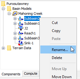
Element names are essential when working on projects. We will rename the elements in this project to make them easier to identify. To rename an element, right click the element in the Watershed Explorer and select Rename.
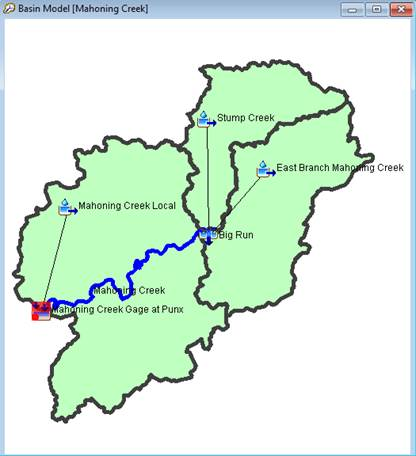
Rename the top-right subbasin Stump Creek, the bottom-right subbasin East Branch Mahoning Creek, and the subbasin below the confluence Mahoning Creek Local.
Rename the reach Mahoning Creek.
Rename the junction at the confluence of Stump Creek and East Branch Mahoning Creek Big Run.
Rename the sink element at the outlet Mahoning Creek Gage atPunx.
Another method of renaming multiple elements is to right lick on the Mahoning Creek basin model and select Rename Basin Elements... This allows you to rename multiple elements in one table.
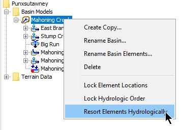
All elements should already be connected to one another and the elements can be sorted hydrologically in the Watershed Explorer. Right click on top of the Basin Model name in the Watershed Explorer and choose the Resort Elements Hydrologically option. Elements will be sorted from upstream to downstream. The table shows the element connections (you can see this information within the element's Component Editor too). Sorting the elements hydrologically will confirm element connectivity is correct.
Upstream Element
Downstream Connection
East Branch Mahoning Creek
Big Run
Stump Creek
Big Run
Big Run
Mahoning Creek
Mahoning Creek
Mahoning Creek Gage at Punx
Mahoning Creek Local
Mahoning Creek Gage at Punx
Check Subbasin Area with Published Information
Check the drainage area from the GIS delineation with published information. One option is to use the drainage area of streamflow gages. The drainage area for the Mahoning Creek at Punxsutawney gage is listed as 158 square miles, https://waterdata.usgs.gov/usa/nwis/uv?03034000. Open the Subbasin Area global editor by going to Parameters | Subbasin Area. The total drainage area for the three subbasins is 157.3 square miles, which is very close to published information.
Questions:
1) Can two basin model elements have the same name?
No, it is not possible to have elements with the same name in HEC-HMS. Each element name must be unique within a basin model.
2) What is the character limit for basin model element names?
You can use up to 28 characters when naming Basin Model elements. Use as many characters as possible to define descriptive names.