Download PDF
Download page Reading DSS Data.
Reading DSS Data
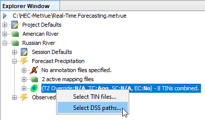
The DSS Data Reader provider is used to read gridded and TIN data from DSS files. To select data from a DSS file, right-click on the node in the Project Explorer window denoting the TINs selected for either the project, session, or map window of interest. An example is shown below. Selecting this brings up the following dialog samples. Note that the dialogs shown in this example are examples. The actual look of the dialog will change depending on the options selected. For example, whether the option to use absolute or relative time specifications is selected, but the functionality is as described in the accompanying tables below.
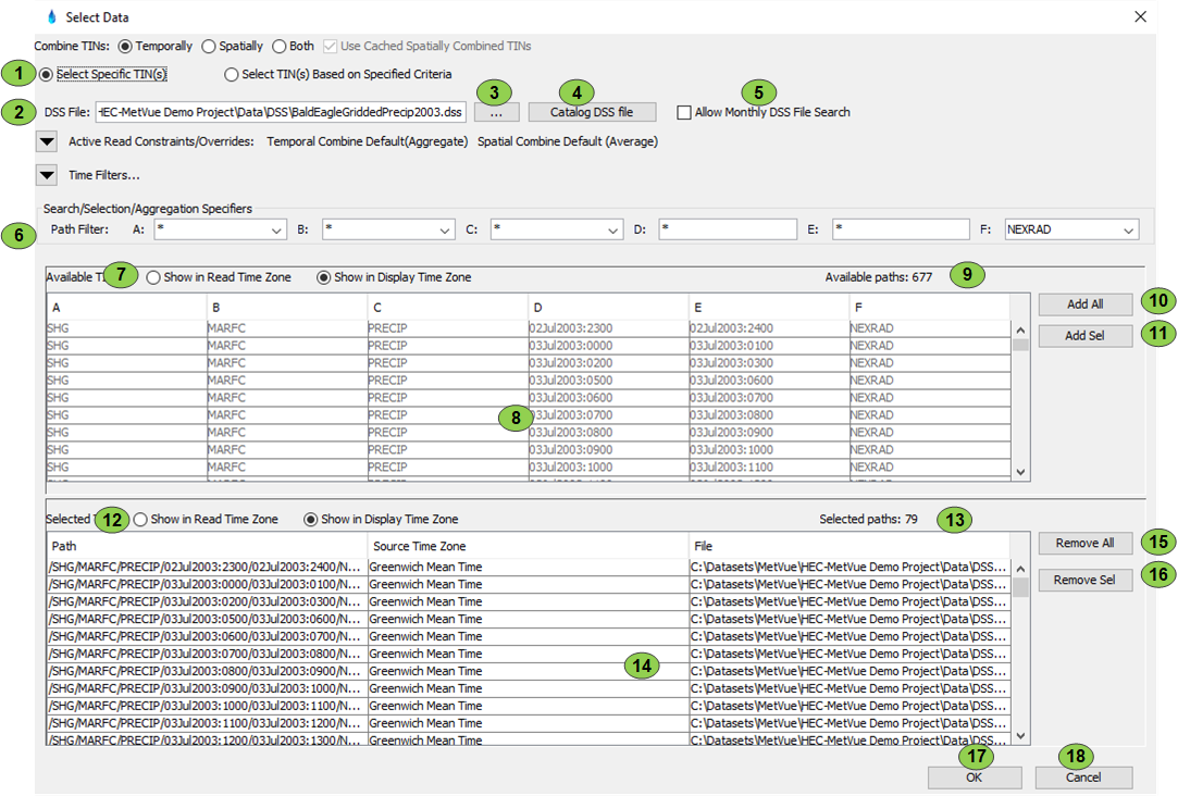
The "Select Data" dialog is an example of the selection editor when used to filter selections from a DSS file. Note that only components specific to this reader are listed below. For further information on other components, refer to Combining Data Options, Reading with Time Filtering, Spatial Extent Constraint Options and Time Zone Override Options. The Select Specific Path(s) mode allows manual selections from the filtered path list. When operating in this mode, since the actual paths are manually selected, the 'Selected Paths' list will never change without taking some action to manually edit the list. The 'Available Paths' list will change depending on the paths in the DSS catalog file along with the path, time, and duration filters. In this mode, the filters are used solely to make the list of paths to select from more manageable. Using this mode, it is possible to select paths with different characteristics or even from different DSS files into a single map window. In fact, the paths read can even be stored in different time zones; therefore, it would be possible to aggregate observed hourly radar data stored in Pacific Standard Time from one DSS file with 6 hour QPF data store in GMT from a different DSS file.
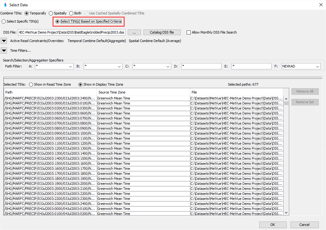
Below is an example of the selection editor when used to filter selected paths from the DSS file. When operating in this mode, the paths selected are based solely on the path, time, and duration filters. All the paths selected will conform to the same path, time, and duration filters and come from the same DSS file. Every time the program is started, the lists of paths is re-evaluated based on the current time in conjunction with the existing filter settings that were previously selected and the current contents of the DSS file. While displaying the editor, every time a filter is changed, the list of matching paths is reevaluated based on the current time. Once the editor is dismissed by pressing the 'OK' button, the filtered list of paths is not re-evaluated until the program restarts or the editor is displayed and 'OK' is again pressed. This guarantees that right-clicking on the map window context menu to refresh the TINs will give the same results as when the filtered list was originally created. Of course, if the contents of the DSS file changed, the change may impact the paths that could actually be retrieved. The Project Explorer window can help with detecting this situation along with many other anomalies when dealing with DSS based data.
Item | Description |
1 | When 'Select Specific Path(s)' is selected, the listing of available paths is shown. Refer to the discussion above for a detailed explanation of this option. When "Select Path(s) Based on Specified Criteria" option is selected all the filter criteria is available but the 'available paths' portion of the control is not shown. All the selected paths are based on the constraints of path parts and time filtering. Refer to the discussion above for a detailed explanation of this option. |
2 | Used to select the DSS file to use. Multiple paths from multiple DSS files can be selected if option 3 is used. If option 4 is used the path selection is restricted to data retrieval from a single DSS file. |
3 | This is used to select a DSS file from the file system. |
4 | This catalogs the DSS file so that the search/selection criteria shows the paths that are in the DSS file. |
| 5 | This specifies that data should be read with the CWMS monthly DSS file naming conventions (i.e. precip.20201.07.dss) |
6 | This is the control for filtering DSS by path part. The dropdown lists contain all the possible parts for the A, B, C, and F path parts that a DSS file contains. These fields are editable so, for example, if a DSS file contained A parts of SHG, SHGEDITED, HRAP, and HRAP-EDITED; using a mask of HRAP* would show all paths starting with HRAP and exclude everything else. The D and E path filters can be used to put in a mask to filter the results. The D and E filters are only available if date range filtering is not being used. |
7 | Paths are read and filtered based on either the default time zone (GMT) or the overridden time zone. The paths can be shown in the read time zone or the display time zone for the session. The read time zone shows the paths exactly as they are recorded in the DSS catalog. When the display time zone is selected, the pathnames are modified to show them in the context of the display time zone. |
8 | This list displays the paths from the selected DSS file that matches the filter criteria. Paths that are shown as greyed have already been selected into the 'Selected Paths' list. |
9 | This shows the number of paths that match the filter criteria and are displayed in the related list. |
10 | This option will add all the paths shown in the 'Available Paths' list to the list of selected paths. |
11 | This option will add the highlighted paths from the 'Available Paths' list to the list of selected paths. The paths can be highlighted by clicking with the mouse. Multiple paths can be selected by using the normal control and shift keys in conjunction with the left mouse click. |
12 | This controls how the selected paths are displayed in the accompanying list. The read time zone shows the paths exactly as they are recorded in the DSS catalog. When the display time zone is selected, the pathnames are modified to show them in the context of the display time zone. The 'Source Time Zone' column displays the time zone that will be used when the path is read from the file. |
13 | This shows the number of paths in the list of selected paths. |
| 14 | This list displays the selected paths and the file that contains them to be aggregated together. |
15 | This button can be used to clear the selected paths list. |
16 | This button will remove the highlighted paths from the list of selected paths. The paths can be highlighted by clicking with the mouse. Multiple paths can be selected by using the normal control and shift keys in conjunction with the left mouse click. |
17 | Accepts the selections made. If the selection is being made for a map window or a map window inherits these settings then the program starts a process to aggregate these images. If no map window (perhaps a session with no active map windows) currently uses these settings, then the information is stored until needed and no action is taken. |
18 | Cancels any changes made. All edits are discarded. |