Download PDF
Download page Cross Sections.
Cross Sections
Cross sections are developed based on the location layout of cross section lines and properties from other layers such as the River, Bank Lines, and Terrain layers. Cross sections should be laid out perpendicular to where water will flow in the channel and overbank areas. Therefore, most cross section lines should be created from a minimum of four points (the end points and points at the edge of the main channel). Cross sections will also be visualized when looking in the downstream direction; therefore, they should be created from left to right when looking downstream (RAS Mapper will automatically flip the line to have the correct orientation). There are many considerations when developing cross section data for orientation, locating, and spacing, but keeping in mind that the cross sections should represent a smooth transition in geometry (elevation and area) and properties (conveyance, surface roughness, etc) is paramount. Use the terrain, river centerline, bank lines, flow path lines, inundation mapping, and other data to properly place cross section lines.
As each cross section is created, RAS Mapper will automatically compute the River Name, Reach Name, River Station, Bank Station, Reach Length and other data for the cross section (assuming the corresponding layers were already created). Elevation data will also be automatically extracted. Cross section properties will continue to be updated each time a cross section cut line is edited. Therefore, the river station value will be updated as you edit the cross section layout, each time you finish editing the feature (close it). This may break linkages with other RAS data that depends on the river station.
Cross section data will only be automatically updated during a cross section’s first edit session, while it is considered a “new” cross section. To update the elevation profile data in subsequent sessions, you will need to manually update it through the menu system – right-click on the Cross Section layer and select Update and the property you would like to update, as shown the figure below. If you would like the cross section properties to automatically update, see the RAS Geometry Properties for the editing session as discussed in Updating Geometry section.
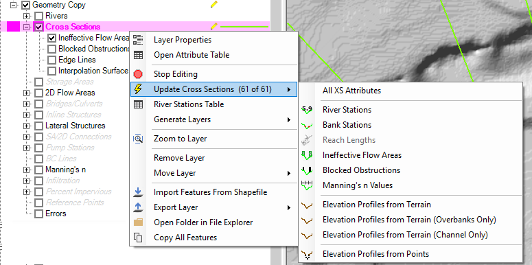
Individual or multiple selected cross sections can be updated by left-clicking on the cross section and choosing from the Update menu options.
XS Properties
Cross section properties are assigned to the cross section as the cross section location lines are laid out. Properties can be updated at any time using the Update options on per cross section basis or doing the entire layer at once. A summary of the update options along with description of the layers need to compute the properties is provided below.
| Cross Section Property | Description |
|---|---|
River Station | The intersection of the River layer and the Cross Sections layer is used to compute the River Station based on the distance from the most downstream point on the river reach line. This distance can be "overwritten" using the River Station Markers layer. |
Bank Stations | The intersection of the Bank Lines layer and Cross Section layer is used to compute the Bank Station locations for each cross section. |
Reach Lengths | The distance between the cross sections in stored as the Reach Length property. The Channel reach length is computed as the distance between cross sections along the River line. The Left and Right Overbank reach lengths are computed as the distance between cross sections based on the Flow Path Lines layer. |
Ineffective Flow Areas | The begin and end location for ineffective flow area are computed based on the intersections of the Ineffective Flow Areas layer and the Cross Section layer. A default "trigger" elevation is computed based on the highest elevation extracted from the Terrain layer at the intersection points. |
Blocked Obstructions | The begin and end location for blocked obstructions are computed based on the intersections of the Blocked Obstructions layer and the Cross Section layer. A default "trigger" elevation is computed based on the highest elevation extracted from the Terrain layer at the intersection points. |
Manning's n Values | Roughness coefficients are extracted based on the intersection of the Mannin's n layer and the cross section layer. |
Elevation Profiles from Terrain | Ground surface elevations are extracted from the RAS Terrain layer for the entire cross section. |
Elevation Profiles from Terrain (Overbanks Only) | Ground surface elevations are extracted for the overbanks portion of the cross sections from the RAS Terrain layer. |
Elevation Profiles from Terrain (Channel Only) | Ground surface elevations are extracted for the channel portion of the cross sections from the RAS Terrain layer. |
Elevation Profiles from Points | Elevation are extracted from a specified point shapefile where each point has an associated elevation. The Elevation Update editor will be opened for the user to choose the point shapefile, apply settings for each cross section, and select the cross sections you wish to update. |
 XS Plot
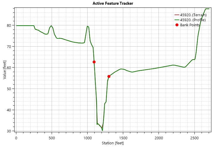
When laying out cross sections, a preview of the elevation profile is available of using the XS Plot button. If you are modifying an existing cross section, the plot will show the existing cross section along with the profile of the ground surface based on the RAS Terrain. As you modify the cross section line the plot will actively update.
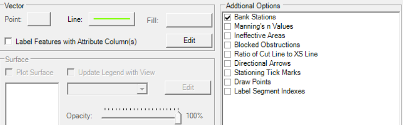
Display Properties
Additional plotting options are available on the Cross Section layer. The additional options (shown below) allow you to visualize important information about the cross section such as the location of Bank Stations, Manning's n Values, and Ineffective Flow areas. The symbology for these options is not user-definable.
Elevation Profiles from Points
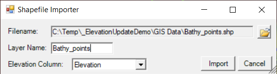
If you have ground surface elevation point data, you can update cross section profile elevations with the Update Elevations by Points editor. This option is intended to assist users in updating cross section where new bathymetric data are available to update an existing set of cross sections. To use this option, you must first add a point shapefile to RAS Mapper using Map Layers | RAS Layer | Add an Existing Elevation Point Layer option. The elevation point layer must have and Elevation column or be a PointZ shapefile. Select the shapefile, provide a name for the layer in RAS Mapper, and specify the field with Elevation data. Press the Import button.
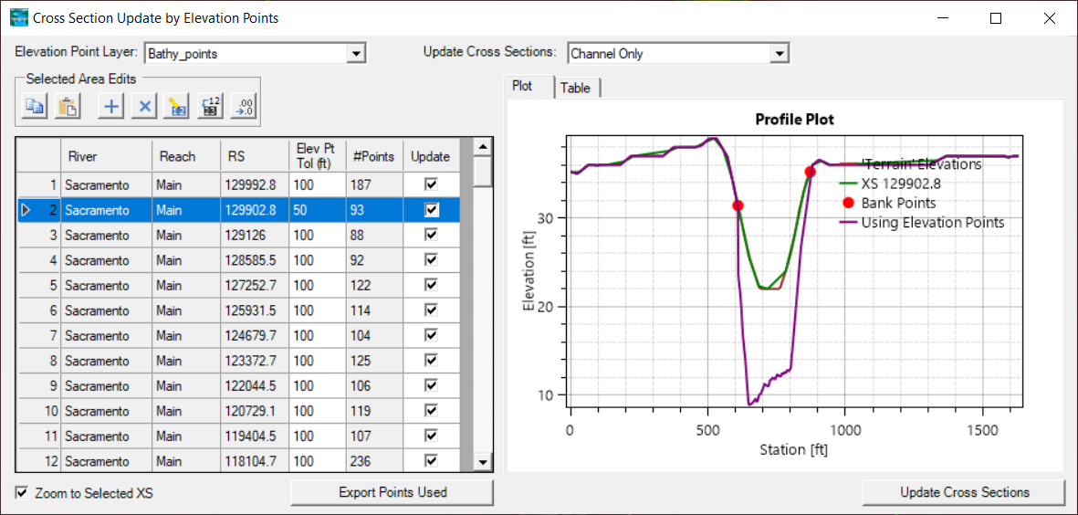
If an Elevation Point Layer has been specified, Start Editing the Cross Sections layer and select Update | Elevation Profile by Points. The Update Elevations by Points editor (shown below) will allow you to specify the Elevation Point Layer and define the portion of the cross section to update (Channel Only or Entire Cross Section) in a table. On the right side of the editor, a Plot of the existing and preview cross section is displayed. You can then specify the tolerance to look for points upstream/downstream from from the cross section and whether to update each cross section. Once the data table specifics have been finalized, use the Update Cross Section button to save the new cross sections. (It is always prudent to save a copy of your geometry before you update cross sections.)
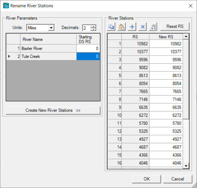
River Stations Table
The River Stations Table option provides you with the ability to rename/recompute the cross section's river stations. The Rename River Stations editor will allow you to set a river station to an exact value or recompute it using specified units, decimal places and the Starting Downstream River Station. Click the Create New River Stations once the river parameters have been entered. If you the results are not desirable, use the Reset RS button to set the stations back to their previously saved values or choose Cancel.