Introduction
The U.S. Army Corps of Engineers (USACE) operates more than 700 storage reservoir, lock and dam, and diversion projects constructed under the USACE's Civil Works water resources program. The USACE water management mission is to regulate river flow with these projects to provide national benefits of flood control, navigation, hydroelectric power generation, water supply, irrigation, erosion control, water quality, environmental enhancement, and other authorized purposes. For USACE offices, the Corps Water Management System (CWMS) software was developed to aide in addressing real-time decisions. CWMS expanded and enhanced the data and information available to USACE staff members who must make decisions about the operation of Federal water management facilities or who must monitor and approve such decisions made by operation partners. The data and information made available through CWMS includes precipitation data and flow forecasts as well as data and information about the current state of watersheds, likely future state of watersheds, and consequences of management actions. The data and information help water managers and others make informed operation decisions.
The Hydrologic Engineering Center's (HEC) Real Time Simulation (HEC-RTS) software is based on the CWMS software for use by non-USACE offices. HEC-RTS still provides the same data and information that CWMS provides, HEC-RTS just performs these functions in a different manner than CWMS. HEC-RTS provides support for operational decision making by forecast simulation modeling using any combination of the following models: rainfall-runoff modeling with HEC-HMS (Hydrologic Modeling System software) based on gaged or radar-based precipitation, Quantitative Precipitation Forecasts (QPF) and other future precipitation scenarios provides forecasts of uncontrolled flows into and downstream of reservoirs, simulation of reservoir operations with either HEC-ResSim (Reservoir System Simulation) or CADSWES's RiverWare provides operational decision information for the engineer, the river hydraulics program HEC-RAS (River Analysis System) computes river stages and water surface profiles for these scenarios, an inundation boundary and depth map of water in the floodplain can be calculated from HEC-RAS results using the RAS Mapper tool, and the impacts of different flow alternatives are computed by HEC-FIA (Flood Impact Analysis). The user-configurable sequence of modeling software allows water managers to evaluate operational decisions for reservoirs and other control structures, and view and compare hydraulic and economic impacts for various "what if?" scenarios.
Version 3.1.1 of HEC-RTS shares a common interface with the Watershed Analysis Tool (HEC- WAT) and several other HEC software applications. The common framework allows models to be used in either a planning alternative application or for real-time forecasting and decision making. The framework provides mechanisms for HEC-RTS to communicate directly with the software applications, running as independent processes.
HEC-RTS and the software applications share a common geo-referenced Desktop Pane (Figure 1.1) that can have an Internet map background, such as Google® or Bing®. Each software application registers and draws geo-referenced model objects on the map panel, such as a reach, cross-section, subbasin, junction, etc. When a user selects one of those objects, HEC-RTS sends a message to the software application and the software application displays a dialog box associated with that object. For example, by selecting a cross section from a map window, the user will bring up the HEC-RAS Geometry Editor for that cross section.
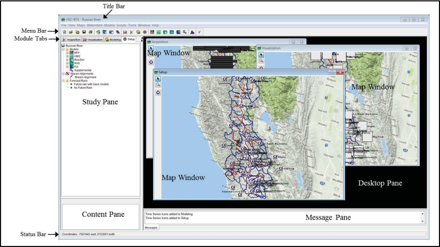
Figure 1.1 HEC-RTS Main Window
When in the Modeling Tab, there is an Actions and Reports panel. From the Actions Panel, when a model is selected, that model displays a list of commands (buttons) that can performed by that model, such as compute, set loss rates, change routing coefficients, etc. Selecting a command brings up the appropriate software application editor or performs an action. Similarly, the Reports Panel displays a list of commands for reports (plots, tables) from each of the software applications, which are displayed when selected.
The integration with HEC-RAS provides a mechanism for computing flood inundation maps in real-time using forecasted flows from HEC-HMS and HEC-ResSim. The inundation maps can display flood depths and boundaries based on various rainfall scenarios and/or reservoir operations or other alternatives that can affect stages and flow. The maps are overlaid on an Internet map background (chosen by the user) or a geo-referenced photo, allowing the user to zoom in and see detailed depths. The HEC-RAS Mapper Tool can write selected maps in a Google® format that can be placed on a server and seen in the field on an iPad or smart phone.
This document is a guide to setting up a watershed for HEC-RTS and is not comprehensive. The Quick Start Guide is intended to be used along with the User's Manual.