Task 1: Evaluating Basin Conditions
Examine the Status of Data in the Russian River Watershed
The state of the watershed determines what operations are appropriate to regulate flows. If your data systems have failed, you cannot know the state of the watershed. The first thing you need to do in daily operations is to make sure that your data is complete and current.
- Open the CAVI from your desktop and open the Workshop_HEC_RussianRiver watershed.
- Switch to the Data Acquisition module.
- Run the USGS and CDEC scripts to bring the data at the reservoirs to near-current conditions (retrieve data for the last 5 days).
Look particularly at the time series quality bars for the two reservoirs. (It might be helpful to set the Icon Layers visible in the map to Flow and Reservoir only.)
What data is displayed there?
What do the colors on the color bars mean?
Is the reservoir data current, or is any data missing?
If there is still significant missing data, alert the data acquisition team so that the problem can be resolved and the missing data posted.
If there are small gaps in the data at the reservoirs that can safely be interpolated, use Data Validation to fill in the gaps. Right click the quality color bar and select Validate. Select OK to continue to the Data Validation Editor.
If there are no gaps in the data, continue on.
Examine the Current Hydrologic Conditions in the Basin
Now that your data is up-to-date, look at the condition in the watershed. Are conditions changing? What's the weather like? Will a model run help you make decisions?
- Switch to the Data Visualization module.
- Look at the thumbnail plots around the basin. Use the Layers selector to show thumbnail plots separately for flow and the conditions at the reservoirs.
Generally, what is happening in the basin? Is it raining? Are the flows increasing or decreasing?
By viewing plots at locations in the basin you will learn more about the current conditions of the watershed.
Do you see any inconsistencies in the data for the basin? If so, what should you do about them?
If inconsistencies are minor, you can simply use the Validate Data tool to remove bad values. If there are major inconsistencies, you should alert your local data acquisition team to correct the issues.
Look at the current status of the reservoirs and compare them to the table below.
Reservoir | GC Elevation | GC Elevation |
Coyote Lake | 748 ft. | 737.5 ft. |
Warm Springs Lake | 451 ft. | 451 ft. |
Are the reservoirs at their target elevations?
Are the reservoir pools rising or falling?
Are conditions in the basin likely to change soon?
What is the current weather forecast for the Russian River area? (Look at a weather forecast for the Russian River using your favorite weather website. The zip code for Geyserville, CA is 95441.)
Is the hydrologic state of the watershed likely to change in the next few days?
Assuming that you trust the models for this basin, would it be worth the effort to make a model run this morning?
Select a Forecast Time
Before selecting a forecast time, you need to answer three questions:
- What is the latest time you have enough data to make a model run?
- How far back do you need to go to establish hydrologic conditions in the basin for the models?
- How far ahead can you realistically make a forecast?
You cannot really answer the third question without more knowledge of the basin, but you should be able to make a reasonable estimate for the first two.
- Switch back to the Data Acquisition Module.
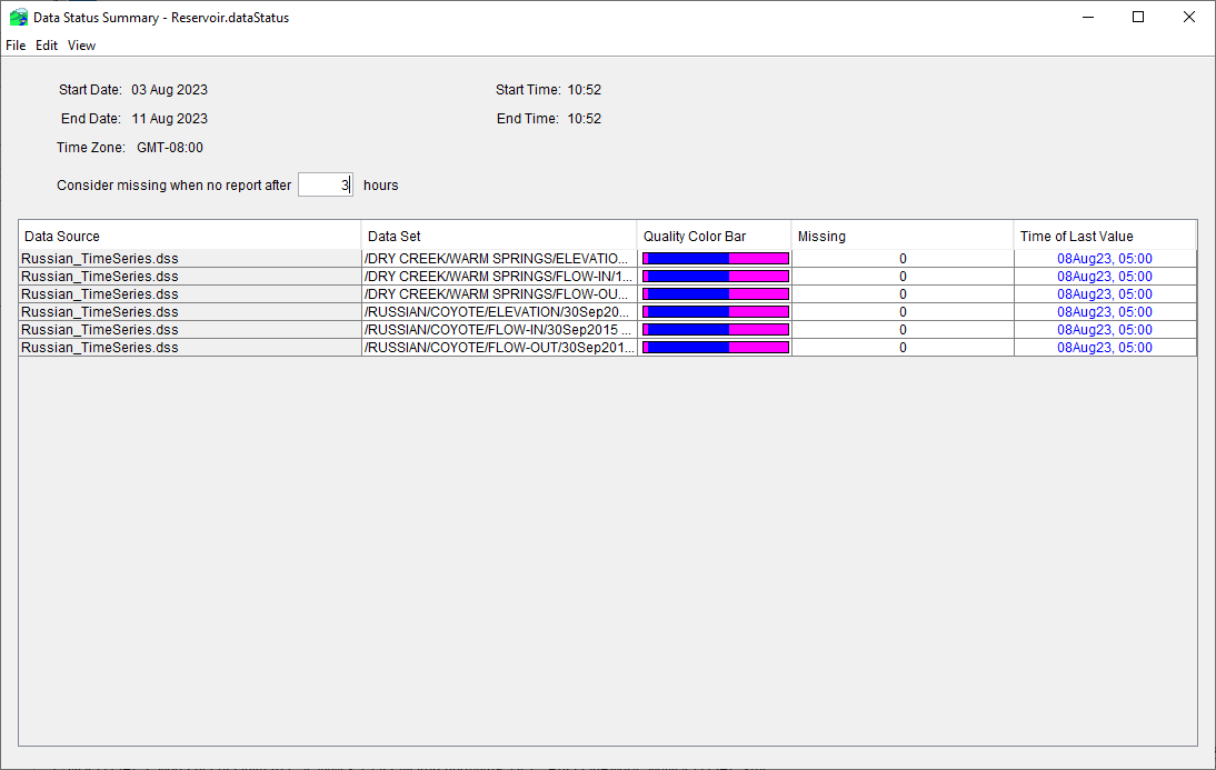
- Select Data Status Summary from the Reports menu.
- If you do not see a data status summary panel like the one below, select Open from the File menu, browse to C:/CWMS_class/watershed/Workshop_HEC_RussianRiver/shared, and open the Reservoir.dataStatus file.
- From the View menu on the summary panel, select Time Window. Set the time window to 3 days before current time and 4 hours forward, and then select OK. Your data status report should look similar to the one shown below.

- You can edit this list by highlighting one or more rows, then selecting Delete Row(s) from the Edit menu to remove time series from the list.
- Remove all the time series from the list except for the reservoir elevations and releases (the critical data required for the HEC-ResSim model to run). These are the ELEVATION and FLOW-OUT time series at Lake Mendocino (Coyote Dam) and Lake Sonoma (Warm Springs Dam).
- Once you have trimmed the list to this minimum set, save the edited list as Critical.dataStatus.
- If these are the essential time series to run the HEC-ResSim model, what is an appropriate Time of Forecast to select for a simulation?
- What is an appropriate Start Time to select for a simulation?