Download PDF
Download page Introduction to Gridded Snowmelt Calibration.
Introduction to Gridded Snowmelt Calibration
Last Modified: 2024-06-13 06:35:20.131
Software Version
HEC-HMS version 4.12 was used to create this example. You can open the example project with HEC-HMS v4.12 or a newer version.
Objectives
In this workshop, you will gain experience developing and calibrating one or more of the gridded snow accumulation and melt methods available in HEC-HMS. HEC-HMS version 4.12 has three gridded snow methods: Gridded Temperature Index, Gridded Hybrid, and Gridded Energy Budget. This workshop focuses on setting up a model application and calibrating using a subbasin-average snow water equivalent time series and observed streamflow time series. Calibrating the model will aid in understanding how individual snowmelt model parameters impact the simulated snow accumulation and melt as well as runoff. The required meteorologic components for each snowmelt model are shown in the table below.
| Method | Gridded Temperature Index | Gridded Hybrid Snow | Gridded Energy Budget |
|---|---|---|---|
| Summary | Uses air temperature as a proxy for available snowpack energy | Uses a radiation balance, rather than temperature, as a proxy for available snowpack energy | Physically-based energy and mass balance model |
| Required Meteorologic Components | |||
| Precipitation | X | X | X |
| Temperature | X | X | X |
| Shortwave Radiation | X | X | |
| Longwave Radiation | X | X | |
| Wind Speed | X | ||
| Atmospheric Pressure | X | X | |
| Relative Humidity | X | X | |
Tasks
The following major tasks will serve as an outline for the workshop:
- Review the existing HEC-HMS project.
- Create a Meteorologic Model and parameterize the requisite methods.
- Create a new Basin Model, select a snow method, and parameterize the snow method.
- Create a Simulation and evaluate results.
- Repeat for additional snowmelt methods.
Study Area
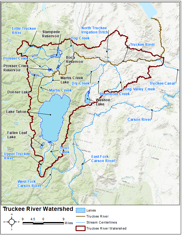
In this tutorial group, the study area is designated as the Upper Truckee River watershed upstream of the USGS stream gage at South Lake Tahoe, CA. The Upper Truckee River watershed is part of the larger Truckee River watershed. The Truckee River originates as the Lake Tahoe outlet in California and flows approximately 105 miles north and east into Nevada. Major population centers within the Truckee River watershed include the cities of Truckee, CA, Reno, NV, and Sparks, NV with a total population greater than 350,000 (as counted during the 2010 census). While the Truckee River provides a major source of water for its nearby inhabitants, the river is also prone to significant flooding. Substantial damage has occurred during large scale and widespread rain-on-snow flood events in 1996-1997, 2005-2006, and 2016-2017 (amongst others). Numerous state and federal water supply and flood risk management projects have been constructed within this watershed. Several major federally-constructed projects include Martis Creek, Prosser, Stampede, and Boca dams, as shown below.

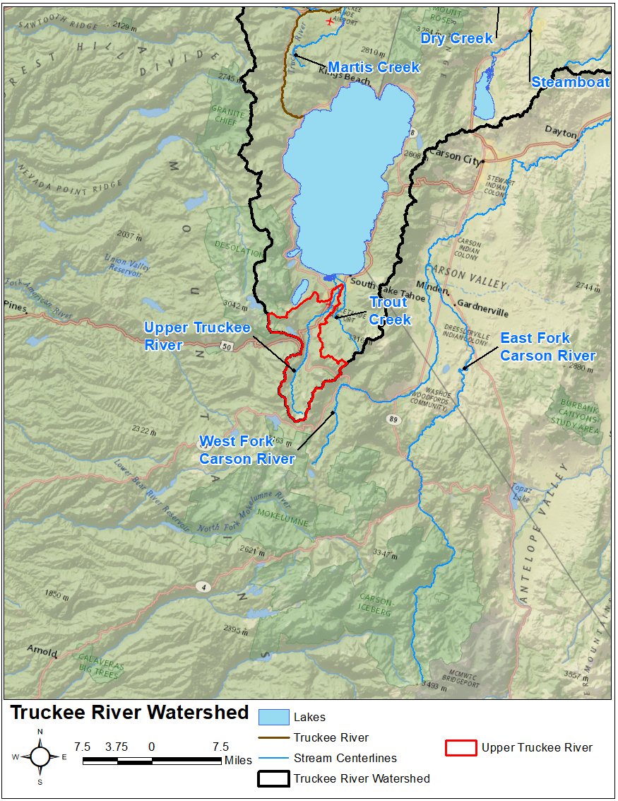
The Truckee River watershed offers an excellent opportunity to investigate snowmelt modeling techniques within a real-world watershed that contains an extremely large amount of meteorological, snow, and river observation stations. Approximately 50 active stream gages are maintained by the USGS while approximately 20 Snow Telemetry (SNOTEL) stations are maintained by the Natural Resources Conservation Service (NRCS). The Upper Truckee River watershed encompasses an approximate 54 sq mi drainage area upstream of Lake Tahoe, as shown below.

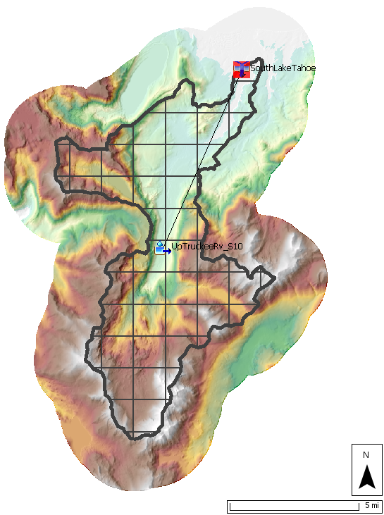
Elevations within the study area range from approximately 1175 ft to 2260 ft as referenced to the North American Vertical Datum of 1988 (NAVD88), as shown in the figure below.
Review Existing HEC-HMS Project
An HEC-HMS project named Upper_Truckee_River has already been created for you. This HEC-HMS project contains a Basin Model named WY2017, a Control Specification named WY2017, two Time Series, several Grid Sets, and a Terrain. As shown below, there is one subbasin element named UpTruckeeRv_S10 which is connected to a junction element named SouthLakeTahoe within the existing basin model. This subbasin was originally delineated using terrain data downloaded from the USGS National Map Viewer.

The subbasin element was configured to use a 2000-meter SHG Structured discretization, the Simple canopy method, the ModClark unit hydrograph transform method, and the Linear Reservoir baseflow method. The previously-mentioned observed SWE and discharge time series were linked to the subbasin and junction elements as observed time series, respectively.
Data
The time period spanning 01Oct2016 through 15Aug2017 will be simulated within this tutorial using a 1-hour time step. The following data has been collected and imported to the existing HEC-HMS project for your use:
| Data Type | Source |
|---|---|
| Precipitation | Multi-Radar/Multi-Sensor System (MRMS) |
| Air Temperature | Real-time Mesoscale Analysis (RTMA) |
| Shortwave Radiation | Interpolated from point measurements at South Lake Tahoe Airport |
| Longwave Radiation | Interpolated from point measurements at South Lake Tahoe Airport |
| Windspeed | Interpolated from point measurements at South Lake Tahoe Airport |
| Atmospheric Pressure | Interpolated from point measurements at South Lake Tahoe Airport |
| Relative Humidity | Interpolated from point measurements at South Lake Tahoe Airport |
| Streamflow | South Lake Tahoe USGS gage |
| Snow Water Equivalent Depth | Subbasin-Averaged Time Series from SNODAS data |
Create a New Meteorologic Model and Parameterize
- Open the HEC-HMS project.
- Once the project opens, select Components | Meteorologic Model Manager | New....
- Enter WY2017 as the Name. Click Create to finalize the creation of this new Meteorologic Model.
- In the Watershed Explorer, expand the Meteorologic Models folder and select the WY2017 node.
- Set the Unit System to U.S. Customary.
- Set the Replace Missing option to Set To Default.
In the Component Editor, select each process, assign the appropriate grid, and parameterize the following methods as shown in the table below:
Process Method Grid/Parameterization Shortwave Gridded Shortwave
Interp_Shortwave
Longwave Gridded Longwave Interp_Longwave Precipitation Gridded Precipitation MRMS_corrected Temperature Gridded Temperature RTMA Windspeed Gridded Windspeed Interp_Windspeed Pressure Gridded Pressure Interp_Pressure Dew Point Gridded Humidity Interp_Humidity Evapotranspiration Gridded Hamon 0.0065 Replace Missing Set to Default N/A Do not change the default Time Shift Method for any of the processes.
Not all snow methods require the same meteorological boundary conditions. However, if properly parameterized, the same Meteorologic Model can be used for all snow methods.
- Click the Save button.
Choose a Snow Method
Now that you have reviewed the existing HEC-HMS project and created a new Meteorologic Model, choose one of the following snow accumulation and melt methods to parameterize and calibrate. If time allows, select a second (or third) method to calibrate.
Option 1. Gridded Temperature Index: Upper Truckee River
