Download PDF
Download page Watershed Sediment Properties.
Watershed Sediment Properties
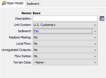
Sediment method is optional component in the Basin Model. By default, the component features are deactivated. Data entry tools for sediment are not visible in the program interface, and no sediment results are computed during a simulation. The sediment features become accessible when they are activated for the Basin Model. Activate the features on the Component Editor for the Basin Model (shown in the following figure). Access the Component Editor by clicking the Basin Model on the Components tab of the Watershed Explorer. Change Sediment to Yes to activate the sediment features. A Sediment tab will appear to the right of the Basin Model Component Editor. You must enter values in the parameter data at each element (subbasin, reach, reservoir, source, and diversion) in the Basin Model. When Sediment is set to No, all parameter data for the sediment methods will be deleted from the Basin Model and its elements. Once the sediment components have been deactivated, it is not possible to recover the deleted settings or parameter values.

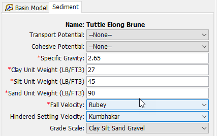
Erosion and Sediment Transport modeling requires a number of properties to be specified. These global properties are applied to all elements in the Basin Model. The properties are presented on a separate Component Editor from the Basin Model editor. The Sediment editor is always shown next to the Basin Model editor (shown in the following figure).

The Transport Potential specifies which method to use to calculate the stream flow sediment carrying capacity for non-cohesive sediments. Different methods have been proposed for calculating the transport potential. Each method has been developed for a particular sediment grain-size distribution and environmental condition. The selected transport potential method will be used at all reaches within the Basin Model. The available choices are shown in the table below.
A cohesive transport potential method can also be selected. When selected, transport of cohesive sediment is computed in addition to the non-cohesive sediment.
Method | Type | Method | Reference |
Ackers-White | NC | SP | Ackers and White, 1973 |
Engelund-Hansen | NC | SP | Engelund and Hansen, 1967 |
Laursen-Copeland | NC | ES | Laursen, 1958; Copeland and Thomas, 1989 |
Meyer-Peter Muller | NC | ES | Meyer-Peter and Müller, 1948 |
Toffaleti | NC | RE | Toffaleti, 1968 |
Wilcock | NC | ES | Wilcock and Crowe, 2003 |
Yang | NC | SP | Yang, 1984 |
Krone Parthenaides | CO | ̶ | Krone, 1962; Parthenaides, 1962 |
Sediment Delivery Ratio | NC/CO | ̶ | Pak and Lee (2012) |
The Specific Gravity must be specified and a default value of 2.65 is provided. The default value should be changed if another value is more appropriate for the watershed.
Sediment unit weights or densities are used to convert deposited or eroded masses into volumes. This is one of the only parameters that is different for SI and US customary units. US customary is defined in terms of unit weights (lb/ft3) while SI is defined in terms of density (kg/m3). HEC-HMS converts between density and unit weight internally.
The Unit Weight/Density of Clay must be specified as appropriate for the selected unit system. The default density is 481 kg/m3 (metric units) while the default specific weight is 30 lb/ft3 (U.S. Customary) . The same density is used for all size subclasses of clay. The default value should be changed if another value is more appropriate for the watershed.
The Unit Weight/Density of Silt must be specified as appropriate for the selected unit system. The default density is 1,041 kg/m3 while the default specific weight is 65 lb/ft3. The same density is used for all size subclasses of silt. The default value should be changed if another value is more appropriate for the watershed.
The Unit Weight/Density of Sand must be specified as appropriate for the selected unit system. The unit weight specified for the Sand will be applied to Gravel, Cobble, and Boulder. The same density is used for all size subclasses from very fine sand to large boulders. The default dry density is 1,490 kg/m3 while the default dry specific weight is 93 lb/ft3. The default value should be changed if another value is more appropriate for the watershed.
Some of the Transport Potential Methods require calculating the Fall Velocity. Fall velocity is also used in several of the Sediment Settling Methods for the reservoir element. All reaches and reservoirs that require the calculation of a fall velocity will use the method selected in the sediment properties. The available methods for calculating fall velocity include Report 12 (Interagency Committee, 1957), Rubey (1933), Toffaleti (1968), and Van Rijn (1993). The default selection is Rubey. Two hindered settling methods, namely Richardson and Zaki (1952) and Kumbhakar (2017), are available for addressing high-concentration debris flow scenarios.
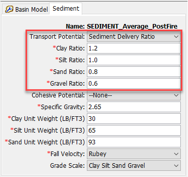
The Sediment Delivery Ratio Transport Potential Method require a ratio of each grain class (Clay, Silt, Sand, and Gravel when Grade Scale is selected as Clay Silt Sand Gravel and Clay, Silt, Sand, and Gravel, Cobble, and Boulder when Grade Scale is selected as AGU 20). A Ratio number is greater than 1 represents an erosional situation, a Ratio number less than 1 represents a depositional situation, and a Ratio number equal to 1 is an equilibrium situation.

Two different Grade Scale systems are available. The selected system will determine the number of grain sizes used for calculating Erosion and Sediment Transport throughout the Basin Model. Erosion, deposition, settling velocities, and transport processes are computed separately for each size. The Clay Silt Sand Gravel System only recognizes four broad size classifications. The AGU 20 recognizes 20 different size classifications, generally breaking each of the four broad size classifications into sub-classifications.
It should be noted that the gradation scale option needs to be considered once the gradation curve range is known. The results for the sediment load/volume are calculated independently of the gradation curve, however, the chosen gradation scale may limit the reported sediment load/volume for that subbasin, as illustrated in the following table.
Grade Scale | ||
Gradation Curve Range | Clay Silt Sand Gravel (0.002 mm – 64 mm) | AGU 20 (0.002 mm – 2048 mm) |
Clay (0.002mm) to Gravel (64 mm) | Covers all grain classes – no sediment load/volume limitations | Covers all grain classes – no sediment load/volume limitations |
Clay (0.002mm) to Large Boulder (2048 mm) | Underestimates sediment load/volume (excludes volume associated with all grain classes > 64mm) – reported sediment load/volume is reduced by the percent of the grain sizes larger 64 mm | Covers all grain classes – no sediment load/volume limitations |