-
-
-
- From the HEC-RTS main window (Figure 1.1), from the Maps menu, click Map Layers. The Map Layers dialog box (Figure 5.2) will open.
-
-
-
- From the Layers menu (Figure 5.10), click Import Image, an Open Browser will open (Figure 5.5). From the browser the user will navigate to where the image file is located, select the image file, click Import, the Open Browser will close (Figure 5.5).
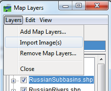
Figure 5.10 Map Layer Dialog Box – Layers Menu - Importing Image(s)
-
-
-
- The Define Image Extents dialog box will open (Figure 5.11). The user will need to provide the extent information for the image file. Once the extent information has be entered, click Finish, the Define Image Extents dialog box will close (Figure 5.11). The selected image file has now been added to the HEC-RTS watershed. For further information on the image extent information, please see the HEC-RTS User's Manual.
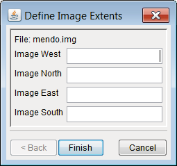
Figure 5.11 Define Image Extents Dialog Box