Impact Area Sets
What is an Impact Area?
An impact area is also known as a damage reach. An impact area consists of a boundary around a given area within the study area. The impact area will typically be defined by upstream and downstream boundaries, and will extend into the floodplain.
What is an Impact Area Set?
An impact area set is a collection of individual impact areas. The collection of impact areas encompasses the study area.
What is the Purpose of an Impact Area?
The impact area is the smallest geographical unit at which we calculate risk (at which we apply the risk equation). An impact area is bound by interval of the channel over which the conditions are relatively homogeneous so that one flow-frequency function and one rating curve reasonably reflect the conditions from the upstream boundary of the impact area to the downstream boundary. Economic results are aggregated to the impact area level for reporting. Impact areas are also used to define the extent of a lateral structure such as a levee.
How Can I Develop a Set of Impact Areas?
Impact areas may be created by drawing boundaries on a map in GIS software and saving the data to a shapefile. See Recommended GIS Skills for more information.
When delineating impact areas, consider consistent discharge- or stage-exceedance probability functions throughout the damage reach, location of flood damage reduction measures, and jurisdiction boundaries for reporting purposes. Normally, impact area delineations evolve through the analysis of the without-project (base year) condition and become fixed thereafter when the location and magnitude of damage is known and types of flood damage reduction measures to be studied are defined. The same impact areas are used throughout for all the analyses of without- and with-project condition. Although there is no limit to the number of damage reaches, the required calculation time for expected annual damage is directly proportional to the number of damage reaches, so it behooves you to define the minimal number that is sufficient. A damage reach containing a levee cannot contain structures that are unprotected by the levee. This may require you to define more damage reaches than what you would otherwise define.
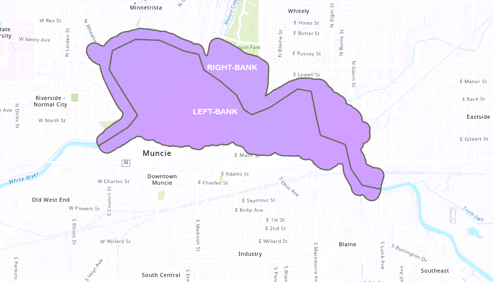
See below for an image of an impact area from Muncie, Indiana. Note that there are two sub-reaches within the impact area: right-bank and left-bank.

Working with Impact Areas in HEC-FDA
Differences Between HEC-FDA Versions 1 and 2
Impact Areas are used the very same way in HEC-FDA Version 2 as they were used in Version 1 (in which impact areas were known as damage reaches). The only difference is the format of the data: in Version 1, impact areas were identified using the boundary (upper and lower) river stations. The use of river stations is how we tricked HEC-FDA Version 1 to consume geographic information. HEC-FDA Version 2 can natively process geospatial data. As such, impact areas are identified as polygons and are imported using the polygon shapefile.
Steps for Importing a Set of Impact Areas
The impact area (formerly known as damage reaches in HEC-FDA Version 1) is the smallest geographical unit at which we calculate risk (at which we apply the risk equation).
- To import impact area set, from the Study Tree, right-click on Impact Area Set and select the import command.

From the Import Impact Area Set dialog, enter a name and description. Click the browser ellipse button to navigate to the appropriate file and click Open to set the shapefile path. Then select the unique impact area name (a field of the attribute table). Click OK to import the dataset.
 Only one set of impact areas may be imported into an HEC-FDA file. This means that all impact areas must be included in one polygon shapefile to be used in a study that contains a field for a unique impact area ID.
Related Information
-
Page:
-
Page:
-
Page:
-
Page:
-
Page:
-
Page:
-
Page:
-
Page:
-
Page:
-
Page:
-
Page:
-
Page:
-
Page:
-
Page: