Import a Cross Section Set
A cross section set is used to define the locations of cross sections within the HEC-FIA project area, as well as to map HEC-DSS data by using pathnames (A, B, and C parts). Watershed components are linked to HEC-DSS files from created inundation configurations; for more information regarding inundation configurations review Inundation Data. A cross section is used to pass information about the depth and extents of water in a river reach and within the floodplain. Cross sections usually have river, reach, and river station values that are used to make each one unique. Cross sections are imported separately from storage areas (refer to Import Storage Areas) as of HEC-FIA Version 3.1; therefore, if the study does not require storage areas, and only cross sections, then the user can just import a cross section set.
HEC-RAS project alternatives may include cross sections that cover the overbank areas in the Without Project Condition, and cross sections that connect to a lateral structure (e.g., a levee) with a storage area in the With Project Condition. This would require that two cross section sets be imported into HEC-FIA, each for a different watershed configuration (refer to Create a Watershed Configuration). From the latest version of HEC-RAS, the HEC-RAS Mapper tool can be used to export cross sections and storage areas to shapefiles; see Export Data from HEC-RAS for further information. Once the shapefiles have been generated, it is a good idea to copy the shapefiles to the maps directory of the HEC-FIA project.
To import cross sections:
From the Study Tree, from the Watershed folder, right-click on the Cross Sections folder. From the shortcut menu, click Import; the Import Cross Sections dialog box opens.
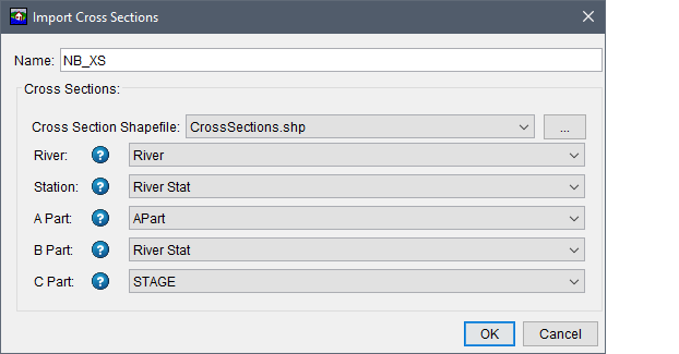
Figure: Import Cross Sections Dialog Box
- In the Name text box, enter a name for the cross section set.
- The Cross Section Shapefile lists the available polyline shapefiles that have been added as map layers to the project. If a map layer that represents the cross sections has not been added to the HEC-FIA project, click the
 button. The Open browser window opens. Browse to the location of the cross section shapefile, select the shapefile (e.g., CrossSections.shp), click Open. The browser window closes and the name of the selected shapefile appears in the Cross Section Shapefile list.
 - Next use the dropdown lists to indentify the attributes in the selected shapefile which represent the River, Station, A Part, B Part, and C Part information. Note the Help
 icon; hover over the Help icon to view tooltips for each cross section component.
The River list allows HEC-FIA to group the cross sections that are on the same river. The Station (river stationing) list allows HEC-FIA to sort the stationing values on the cross section in ascending order. These two steps allow HEC-FIA to create a polygon for the area in between any two cross sections so that structures can identify which cross sections to retrieve hydraulic data from during a cross section compute. Important: Make certain that the data in the shapefile database matches the HEC-DSS data record for each cross section exactly, so that HEC-FIA can find the correct data during a computation. Also, all watershed elements included in a watershed configuration (refer to Create a Watershed Configuration) should contain matching names across the elements. For example, the stream names selected for an imported cross section set should match the river names in the imported stream alignment.
![]()
Figure: Import Cross Sections - Help Icon Tooltip - Example
- The A Part, B Part and C Part lists allow the user to define a partially qualified HEC-DSS path that will be used later by HEC-FIA to link to the HEC-RAS outputs; e.g., stage hydrographs. The A Part is generally a river identifier (e.g., APart in the figure above, although for HEC-RAS it is the river and reach names concatenated with a space in between. The B Part is generally a point location parameter (e.g., River Stat in the figure above; HEC-RAS uses the river stationing for this part. The C Part list contains the option to set type of hydraulic data (e.g., STAGE or FLOW). In general, the C Part should be set to STAGE when using data from cross sections. It is important to note that HEC-FIA interprets the HEC-DSS record as stage when calculating damages at structures.
- Click OK, the Import Cross Sections dialog box closes. The name of the cross section data (e.g., NB_XS) appears in the Study Tree under the Cross Sections folder and the cross sections are displayed in the active map window.
Once imported, the cross section set can be edited:
- From the Study Tree, from the Watershed folder, from the Cross Sections folder, right-click on the cross section set (e.g., NB_XS). From the shortcut menu click Edit and the Edit Cross Section Time Series Mappings dialog box opens.
The user can view and edit the cross section time series from the Edit Cross Section Time Series Mappings dialog box. Either click the cell once to replace the text or double-click to edit part of the text. Once viewing or editing is complete, click Ok to close the dialog and save modifications. Alternatively, click Cancel to close the dialog without saving changes.
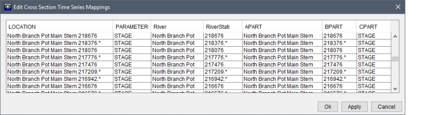
Figure: Edit Cross Section Time Series Mappings Dialog Box - Example