Create a Watershed Configuration
A watershed configuration is a required element in HEC-FIA, and replaces the project configuration used by versions of the software preceding HEC-FIA Version 3.0. The watershed configuration is the HEC-FIA representation of a modeled watershed, which may be representative of the actual watershed or of some structural representation of an alternative that changes elements in the watershed. Many watershed configurations can be created, and the user can define many versions of any element in the watershed configuration to represent different project alternatives. For example, one project alternative may include cross sections that cover the overbank areas in the Without Project Condition, and another project alternative may include cross sections that connect to a lateral structure (e.g., a levee) with a storage area in the With Project Condition.
The base elements of an HEC-FIA watershed configuration consists of a terrain grid, a reservoir set, a stream alignment, a cross sections set, a storage areas set, and a set of common computation points (either standard CCPs or holdout CCPs). Not all of these base elements are required for HEC-FIA to compute a hydraulic event at a location in the study area.
Important: All model elements included in a watershed configuration should contain matching names across the elements. For example, if the watershed configuration is created for the new Flood Damages Reduced compute that contains HEC-RAS leveed storage areas and HEC-ResSim reservoirs with holdout CCPs, then the reservoirs, stream alignment, cross sections, storage areas, and CCPs with holdout distribution areas should all contain the same naming convention across all elements. In other words, the river name shapefile attribute selected for the imported cross sections set (review Import a Cross Section Set) and the imported storage areas set (review Import Storage Areas) should match the river names in the imported stream alignment (review Stream Alignment). There is one exception to this rule; during the compute if HEC-FIA cannot locate the river based on the name provided for the imported storage areas set, then HEC-FIA will determine the stream for the storage area using the centroid of the storage area polygon.
Once the elements of the watershed have been defined using the processes described above, a watershed configuration can be created, as follows:
From the Study Tree, from the Watershed folder, right-click on the Watershed Configurations folder. From the shortcut menu, click New; the Create New Watershed Configurations dialog box opens.
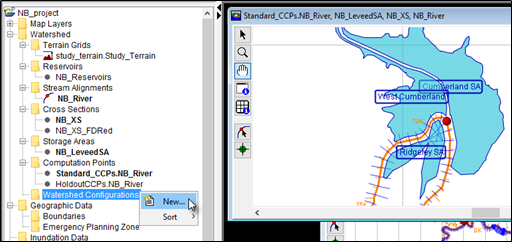
Figure: Watershed Configurations - Shortcut Menu Commands

Figure: Create New Watershed Configuration - Example
- Provide a name for the Watershed Configuration in the Name box on the Create New Watershed Configurations dialog box. From the Description box enter a short description (optional, but recommended). Entered descriptions will appear as a tooltip when the user hovers the cursor over the created watershed configuration's name from the Study Tree.
- Next use the Terrain Grid, Reservoirs, Stream Alignment, Cross Sections, Storage Areas, and/or Computation Points lists to select the desired elements to describe the physical state of the watershed for the new watershed configuration. Each dropdown lists the user-defined name for the imported watershed elements.
Note: The Computation Points list is limited by the selected Stream Alignment and if a reservoir set is selected from the Reservoir list. For example, if a reservoir set is selected then the Computation Points list only provides CCPs with holdout distribution areas. Furthermore, the Computation Points list only provides CCPs associated with the stream alignment selected from the Stream Alignment list (e.g., NB_River in the figure above). - Now that everything is defined, click OK. The Create New Watershed Configurations dialog box closes. Under the Watershed Configurations folder in the Study Tree, the name of the watershed configuration (e.g., Flood_Damages_Reduced) appears.