Download PDF
Download page Introduction to Point Snowmelt Calibration.
Introduction to Point Snowmelt Calibration
Last Modified: 2024-06-20 14:05:17.33
Software Version
HEC-HMS version 4.12 was used to create this example. You can open the example project with HEC-HMS v4.12 or a newer version.
HEC-DSSVue version 3.2.3 was used to download data within this example. You can download HEC-DSSVue here: https://www.hec.usace.army.mil/software/hec-dssvue/downloads.aspx.

Objectives
Starting in version 4.12, HEC-HMS has five snow accumulation and melt methods: Temperature Index, Gridded Temperature Index, Gridded Hybrid Snow, Gridded Energy Budget, and Energy Budget. In this workshop, you will gain experience developing and calibrating one or more of the snow accumulation and melt methods available in HEC-HMS. This workshop focuses on setting up a model application for a point location (i.e. a gaging station) using observed meteorological forcings. Calibration will be performed using at-site data measured at the location. Calibrating the model will aid in understanding how individual snowmelt model parameters impact the simulated snow accumulation and melt.
Calibration of gridded snowmelt modeling methods is contained within this tutorial: Calibrating Gridded Snowmelt: Upper Truckee River, California.
The required meteorologic components for each snowmelt model are shown in the table below.
| Method | Temperature Index | Hybrid Snow | Energy Budget |
|---|---|---|---|
| Summary | Uses air temperature as a proxy for available snowpack energy | Uses a radiation balance, rather than temperature, as a proxy for available snowpack energy | Physically-based energy and mass balance model |
| Required Meteorologic Components | |||
| Precipitation | X | X | X |
| Temperature | X | X | X |
| Shortwave Radiation | X | X | |
| Longwave Radiation | X | X | |
| Wind Speed | X | ||
| Atmospheric Pressure | X | X | |
| Relative Humidity | X | X | |
| Banded Implementation | X | X | |
| Gridded Implementation | X | X | X |
Study Area
The Swamp Angel Study Plot (SASP) is located in the San Juan Mountains in southwestern Colorado. SASP is located at an elevation of 11060 ft and is located in meadow sheltered by the surrounding terrain and subalpine forest. The location of SASP allows for snowpack and precipitation measurements under minimal wind influence. SASP was used in the Earth System Model-Snow Model Intercomparison Project (ESM-SnowMIP). ESM SnowMIP is an international modeling effort that evaluates snow modeling schemes (Krinner et al. 2018).
For this tutorial, the study plot is treated as a point location. A simple HEC-HMS model with a single subbasin element was developed. The study plot has an area of 0.00034 square miles (0.22 acres).
Tasks
The following major tasks will serve as an outline for the workshop:
- Download snow water equivalent (SWE) data for SNOTEL gages near the Swamp Angel Study Plot.
- Create a Meteorologic Model and parameterize the requisite methods.
- Create a new Basin Model, select a snow method, and parameterize the snow method.
- Create a Simulation and evaluate results.
- Repeat for additional snowmelt methods.
Download SNOTEL data through HEC-DSSVue
- Open HEC-DSSVue.
- Create a new file by selecting File | New Ver 7....
- Name the file SNOTEL_SwampAngel and save the DSS file to the data directory of the HMS project: ...\SwampAngel\data.
- Select Data Entry | Import... | SnoTel, as shown below.

- Leave the Data Type as Daily.
- Select the first radio button, next to Start Date. Enter 01OCT2005 as the Start Date and 30SEP2006 as the End Date.
- Click the Get List By State button and select Colorado. Click the OK button. Once the sites load, click the OK button.
- Select the checkboxes for the Red Mountain Pass (713) station. Click the Import to DSS button.

- Verify that the station records were imported. The SWE time series should resemble the figure below. The Red Mountain Pass station has an elevation of 11,080 ft, which is close SASP's elevation. This SWE time series will be used to calibrate the snowmelt parameters in the following tasks.

- Close HEC-DSSVue.
Enter Time-Series Components
- Open the HEC-HMS project.
- Once the project opens, select Components | Time-Series Data Manager.
- Select Snow Water Equivalent Gages from the drop-down menu and click the New... button.
- Enter SNOTEL_SwampAngel as the name and click the Create button.
- Navigate to the newly created Snow Water Equivalent gage in the Project tree and click on the SNOTEL_SwampAngel node.
- Change the Data Source to Single Record HEC-DSS.
- Select SNOTEL_SwampAngel.dss as the DSS Filename.
- In the DSS Pathname field, click the
 button and double left-click the DSS record with a C-part of SWE.
 - The SNOTEL_SwampAngel Snow Water Equivalent Gage Component Editor should resemble the following:

- Click Save.
- Expand the Basin Models folder.
- Expand the SwampAngel node and click the SASP subbasin node.
- In the Component Editor, select the Options tab.
- From the Observed SWE drop-down menu, select the SNOTEL_SnowAngel SWE gage. The SASP Options tab should resemble the following:

- Click Save.
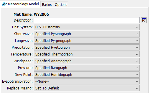
Create and Parameterize a New Meteorologic Model
- Select Components | Meteorologic Model Manager | New....
- Enter WY2006 as the Name.
- In the Watershed Explorer, expand the Meteorologic Models folder and select the WY2006 node.
- From the Component Editor, select the following:
- Unit System: U.S. Customary
- Shortwave: Specified Pyranograph
- Longwave: Specified Pyrgeograph
- Precipitation: Specified Hyetograph
- Temperature: Specified Thermograph
- Windspeed: Specified Anemograph
- Pressure: Specified Barograph
- Dew Point: Specified Humidograph
- Evapotranspiration: --None--
- Replace Missing: Set To Default
- The Meteorologic Model Component Editor should appear as in the figure below.
- Within the Meteorologic Model Component Editor, navigate to the Basins tab. Under the Include Subbasins header, select Yes from the drop-down menu to link both the SwampAngel and SwampAngel_RTI basin models to the WY2006 meteorologic model.
- Select the Specified Pyranograph from the Watershed Explorer. Under the Gage header, select SWRadiation from the drop-down menu.
- Repeat the previous step and make the following selections:
- Specified Pyrgeograph: LWRadiation
- Specified Hyetograph: Precipitation
- Specified Thermograph: AirTemperature
- Lapse Method: --None--
- Specified Anemograph: WindSpeed
- Specified Barograph: AirPressure
- Specified Humidograph: Humidity
- Save the project.
Not all snow methods require the same meteorological boundary conditions. However, if properly parameterized, the same Meteorologic Model can be used for several different snow methods.
Choose a Snow Method
Choose one of the following snow accumulation and melt methods to parameterize and calibrate. If time allows, select a second (or third) method to calibrate.
Option 1. Temperature Index: Swamp Angel Study Plot, Colorado
Option 2. Gridded Hybrid Snow: Swamp Angel Study Plot, Colorado