Download PDF
Download page Option 2. Gridded Hybrid Snow: Swamp Angel Study Plot, Colorado.
Option 2. Gridded Hybrid Snow: Swamp Angel Study Plot, Colorado
Return to: Introduction to Point Snowmelt Calibration
Last Modified: 2024-06-20 14:27:03.4
While the Temperature Index method relies solely upon air temperature to estimate energy available to melt accumulated snow, the Radiation-derived Temperature Index (RTI) or Hybrid method utilizes additional factors to compute a "proxy energy" available for snowmelt. This representative energy is derived from a radiation balance computation that includes simple calculations of net shortwave and longwave radiation (Follum et al, 2015; Follum et al, 2019). Net shortwave radiation includes topographic, cloud cover, vegetation, and albedo effects while net longwave radiation includes contributions from the air, vegetation, cloud cover, and approximate snow temperature. Compared to the Temperature Index method, the RTI/Hybrid approach requires only a few additional meteorological inputs.
The Gridded Hybrid Snow (or Radiation-derived Temperature Index) method is inherently a gridded method. There is no banded implementation of this snow accumulation and melt model. A terrain and discretization file were developed for you to calibrate Gridded Hybrid Snow method parameters at a gage, or point, location.
Create a New Meteorologic Model and Parameterize
- Select Components | Meteorologic Model Manager | New....
- Enter WY2006_gridded as the Name. Click Create to finalize the creation of this new Meteorologic Model.
- In the Watershed Explorer, expand the Meteorologic Models folder and select the WY2006_gridded node.
- Set the Unit System to U.S. Customary.
- Set the Replace Missing option to Set To Default.
In the Component Editor, select each process, assign the appropriate grid, and parameterize the following methods as shown in the table below:
| Process | Method/Option | Grid/Parameterization |
|---|---|---|
| Shortwave | Gridded Shortwave | griddedShortwave |
| Longwave | Gridded Longwave | griddedLongwave |
| Precipitation | Gridded Precipitation | griddedPrecip |
| Temperature | Gridded Temperature | griddedTemp |
| Windspeed | Gridded Windspeed | griddedWindSpeed |
| Pressure | Gridded Pressure | griddedAirPressure |
| Dew Point | Gridded Humidity | griddedHumidity |
| Evapotranspiration | --None-- | N/A |
| Replace Missing | Set to Default | N/A |
Do not change the default Time Shift Method for any of the processes.
Not all snow methods require the same meteorological boundary conditions. However, if properly parameterized, the same Meteorologic Model can be used for all snow methods.
Terrain Preprocessing
Prior to computing a Simulation Run with the Gridded Hybrid snowmelt method, the Slope, Aspect, and Solar Shading of the terrain must be computed. These parameters are computed by right clicking on the terrain and selecting Preprocess Slope and Aspect and Preprocess Solar Shading, as shown below.
These steps have been completed for you. You do not need to re-compute slope and aspect or solar shading.

Parameterize the Hybrid Snow Method
- Expand the existing SwampAngel_RTI node and click the SASP subbasin node.
- In the Component Editor, select the Subbasin tab.
- Change the Snow Method to Gridded Hybrid.
- Click on the Snow tab.
Enter the following parameter values:
Initial Values: Default
The initial snow states can be set to zero because the simulation will start at the beginning of the WY when there is no snowpack.
- Rain Threshold Air Temperature (F): 37
- Snow Threshold Air Temperature (F): 30
- Base Temperature (F): 32
- Melt Factor (IN/DEG F-6HR): 0.00722
- Max Negative Melt Factor (IN/DEG F-6HR): 0.011
- ATI Coefficient: 0.8
- Wind Function (IN/INHG-6HR): 0.667
- Water Capacity (%): 3
Create and Compute a Simulation Run
- Select Compute | Create Compute | Simulation Run....
- Enter WY2006_RTI as the name and select Next.
- Select WY2006_RTI Basin Model, the WY2006_gridded Meteorologic Model, and the WY2006 Control Specifications.
- Click the Finish button.
- In the Toolbar, select the WY2006_RTI simulation from the drop-down menu and click the Compute (exploding raindrop) button.

- When the simulation is complete. navigate to the Results tab.
- Expand the WY2006_RTI node and then expand the SASP subbasin node.
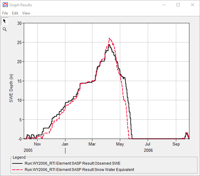
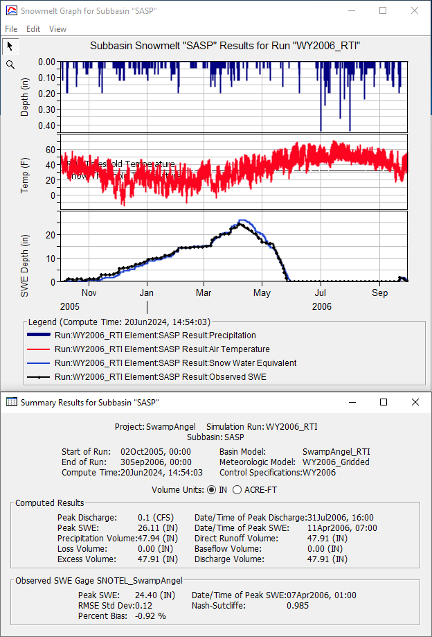
- Select the Observed SWE and Snow Water Equivalent time series nodes. Click the View Graph button, as shown in the figure below. Alternatively, select the Snowmelt Graph to view Precipitation, Air Temperature, Observed SWE, and Snow Water Equivalent in the same window.

Question 1: Using the initial parameter values, how does your simulated SWE compare with the observed SWE? How will you use the preliminary results to inform your calibration approach?
The computed peak SWE is too high when compared against the observed SWE. Also, the computed snowpack melts too soon, as shown below:

Parameters related both to accumulation and melt should be adjusted during calibration.
Calibrate the Hybrid Snow Parameters
Revisit the Hybrid parameters that you defined in the previous task. Modify the parameters in a systematic way and keep track of the effect of the parameter modifications on the simulated SWE. To assist with calibration, plot the Precipitation, Air Temperature, Observed SWE, and Snow Water Equivalent time series using the Snowmelt Graph.
Attempt to increase the peak SWE by modifying the Rain Threshold Air Temperature, Snow Threshold Air Temperature, and Base Temperature.
Decreasing the Rain Threshold Air Temperature will cause more precipitation to fall as rain, resulting in a shallower snowpack.
Increasing the Snow Threshold Air Temperature will cause more precipitation to fall as snow, resulting in a deeper snowpack.
When the air temperature is higher than the Base Temperature, snowmelt occurs. Increasing the Base Temperature will cause the snowpack to last longer since higher temperatures are required to melt the snow.
- Try setting the Rain Threshold Air Temperature to 35 deg F and rerun.
- Try setting the Snow Threshold Air Temperature to 35 deg F and rerun.
- Try setting the Base Temperature to 35 deg F and rerun.
- Continue modifying to best match the peak SWE date and magnitude.
- Attempt to improve the rate at which snow melts and melt out date by modifying the Melt Factor.
- Try decreasing the Melt Factor to 0.0035 and rerun.
- Try increasing the Melt Factor to 0.01 and rerun.
- Continue modifying the Melt Factor to best match the rate at which SWE melts along with the computed melt out date.
- Continue modifying the remaining parameters (e.g. Max Negative Melt Factor, ATI Coefficient, and Wind Function) and note their impact on the computed results.
- Iteratively adjust all impactful parameters to best match peak SWE magnitude, SWE melt rate, and the melt out date.
Question 2: Which parameters had the largest impact on the simulated SWE?
Rain Threshold Air Temperature, Snow Threshold Air Temperature, Base Temperature, Melt Factor, and ATI Coefficient are the most impactful parameters. During calibration, these parameters should be changed to afford better agreement between computed and observed results. Also, when assessing model uncertainty, these parameters should be analyzed and attempts made to minimize their contributions to the overall project risk. Minor changes in computed results were achieved through changes in the Max Negative Melt Function, Wind Function, and Water Capacity.
Question 3: What were the final Gridded Hybrid parameters for the Swamp Angel Study Plot?
The calibrated Gridded Hybrid parameters are shown below. Your calibrated parameters and final results may differ from these.
- The Rain Threshold Air Temperature was decreased from 37 deg F to 31 deg F. This increased the amount of precipitation falling as purely rain.
- The Snow Threshold Air Temperature was increased from 30 deg F to 31 deg F. This increased the amount of precipitation falling as purely snow.
- The Base Temperature was decreased from 32 deg F to 30 deg F. This caused snow melt to start slightly sooner in the season.
- The Melt Factor was reduced from 0.00722 to 0.0045, which slowed the rate of snow melt.
- The Max Negative Melt Factor was reduced from 0.011 to 0.01, which caused the initiation of melt to occur slightly sooner in the season.
- The ATI Coefficient was increased from 0.8 to 0.98. This is used to calculate a temperature index from the current temperature index.


Continue to Option 1. Temperature Index: Swamp Angel Study Plot, Colorado or Option 3. Energy Budget: Swamp Angel Study Plot, Colorado.
