Download PDF
Download page Introduction to the Pak and Lee Dynamic Surface Method.
Introduction to the Pak and Lee Dynamic Surface Method
Last Modified: 2024-12-26 09:20:30.004
Software Version
HEC-HMS version 4.12-beta.1 was used to create this example. You can open the example project with HEC-HMS v4.12 or a newer version.
Project Files
Download the initial project files here:
Arroyo_Seco_Tutorial_Start.zip
The final project files are provided at the end of the tutorial.
Introduction
Natural, unburned vegetation and soil act as a sponge during a rainfall event. Wildfires dramatically change the ground conditions of a watershed, which can lead to increased flood risk. The heat from a fire can bake the ground which creates a hydrophobic soil layer, increasing the speed with which water flows off the burn layer. In addition, more rainfall is expected to runoff as surface and canopy storage is reduced, and evapotranspiration is minimized by the lack of trees and vegetation. The hydrophobic soil layer is eroded by rainfall. However, the recovery of soils can take years. Simulating watersheds in years immediately following a wildfire is difficult with constant soil infiltration rate. The Dynamic Surface method was introduced to HEC-HMS in version 4.11. This method can be used for post-wildfire or other scenarios where a surface layer of vegetation and/or soil limits the amount of precipitation that is able to infiltrate into the soil layer. Post-fire watershed modeling is important for estimating flood risk after fire and the rate of erosion, or recovery, of the hydrophobic surface layer.
Study Area
The Arroyo Seco ("dry stream" in Spanish) originates in the Angeles National Forest and San Gabriel Mountains in southern California. The river joins the Los Angeles River north of downtown Los Angeles. The upper portion of the Arroyo Seco watershed (upstream of USGS 11098000 Arroyo Seco near Pasadena, CA) will be modeled in this tutorial. The watershed has a drainage area of 16 square miles. In August - October 2009, the Station Fire burned a large portion of the national forest. Approximately 95% of the upper Arroyo Seco watershed and 63% of the Arroyo Seco watershed were burned. The burn severity of the Station Fire in the upper Arroyo Seco watershed is shown below (burn severity map accessed from Monitoring Trends in Burn Severity Direct Download page). 
Pak and Lee Dynamic Surface Method
The Canopy, Surface, and Loss layers are conceptualized in the figure below.
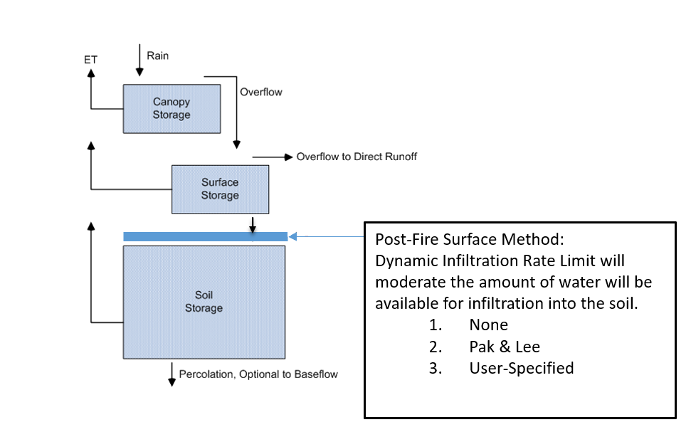
This tutorial will implement the Pak and Lee Dynamic Surface method. In the Pak and Lee method, the infiltration rate of the Surface layer after a fire is calculated as:
K_S_,_t = K_S_,_{init} + (K_S_,_{init}/DecayFactor)
where K_S_,_t is the dynamic infiltration rate t days after the burn and K_S_,_{init} is the initial infiltration limit (i.e. the infiltration value immediately after the wildfire).
The post-fire loss rate,K_S_,_t, is always less than the unburned loss rate, K_S_,_u_n_b_u_r_n_e_d.
The Decay Factor is calculated as (Pak and Lee, 2008):
DecayFactor = (B_p * B_y^{-0.29} + (1.0 - B_p)* (20 - B_y)^{-0.29}) * (2.0 - exp(A_p / 200))
where B_p is the fraction of the watershed that was burned (0 \le B_p \le 1), B_y is the number of years since the burn date (0 \le B_y \le 10 where B_y is a real number), and A_p is the number of antecedent effective precipitation events. The number of antecedent effective precipitation events is determined from the rain intensity threshold and dry duration.
Differences betweek Pak and Lee (2008) and implementation in HEC-HMS
- In the implementation of the Pak and Lee Dynamic Surface method in HEC-HMS, the parameter B_y can vary between 0 and 10 years post-fire. Pak and Lee (2008) varied this parameter between 1 and 10 years post-fire.
- The coefficient of 6.5 used in equation (1) of Pak and Lee (2008) was determined through calibration and is watershed-specific.
Note that when B_p = 0 (the watershed is unburnt), the decay factor and the surface layer infiltration rate still vary. The Pak and Lee surface method is only intended for use in post-wildfire hydrologic modeling.
The following major tasks will serve as an outline for the workshop:
- Initial Model Setup
- Parameterize the Dynamic Surface Method and Compute a Simulation
- Calibrate the Dynamic Surface Method Parameters
- Comparison of Post-fire Simulations with and without Dynamic Surface
Continue to Initial Model Setup.