Download PDF
Download page ModClark Model.
ModClark Model
A distributed parameter model is one in which spatial variability of characteristics and processes are considered explicitly. The modified Clark (ModClark) model is such a model (Kull and Feldman, 1998; Peters and Easton, 1996). This model accounts explicitly for variations in travel time to the watershed outlet from all regions of a watershed.
Basic Concepts and Equations
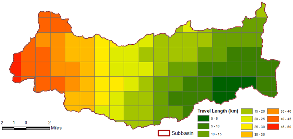
The Modified Clark (ModClark) method explicitly accounts for variations in travel time to the watershed outlet using a gridded representation of the watershed to route excess precipitation to the subbasin outlet (Kull & Feldman, 1998). While the method integrates spatial variability in travel time, the underlying flow velocity field is time invariant. The travel time index for each grid cell, Tt,cell, is set relative to the time of concentration for the watershed, Tc,watershed, using a distance index:
| 1) | T_{t, \text { cell }}=T_{c, \text { watershed }} \frac{D_{c e l l}}{D_{\max }} |
where Dcell is the travel distance from a grid cell to the watershed outlet and Dmax is the travel distance for the grid cell that is most distant from the watershed outlet. As long as the area for each grid cell is also specified, the volume of inflow can be computed as the product of area and excess precipitation. This, in essence, creates a watershed-specific time-area histogram instead of using a smooth function fitted to a typical time-area relationship. Inflows are then routed through a linear reservoir yielding an outflow hydrograph for each grid cell. The current implementation within HEC-HMS assumes the watershed storage coefficient, R, is uniform throughout each grid cell for a watershed (Hydrologic Engineering Center, 2018). The individual outflow hydrographs from each grid cell are then summed to determine the total direct runoff hydrograph.
During the GIS | Preprocess Drainage step, HEC-HMS produces flow direction and flow accumulation rasters that utilize the same horizontal resolution of the underlying terrain (e.g., 10 meters). During the GIS | Compute Grid Cells step, HEC-HMS samples from the flow direction and flow accumulation rasters to determine Dcell using the same horizontal resolution of the discretization (e.g., 2000 meters). A Dmax is then computed for each subbasin.
Required Parameters
Parameters that are required to utilize the ModClark method within HEC-HMS include Tc [hours], R [hours], and a gridded representation of the watershed. This gridded representation must use one of the following systems:
- Hydrologic Rainfall Analysis Project (HRAP), which is based on the Polar Stereographic map projection and is most commonly used by the National Weather Service
- Standard Hydrologic Grid (SHG), which is defined for the conterminous United States and is based on the Albers Equal Area Conic map projection
- SHG grid resolutions of 10, 20, 50, 100, 200, 500, 1000, 2000, 5000, and 10000 meters are supported.
- Universal Transverse Mercator (UTM), which uses a transverse Mercator projection and divides the Earth into 60 zones, each being six degrees longitude in width (Hydrologic Engineering Center, 2013)
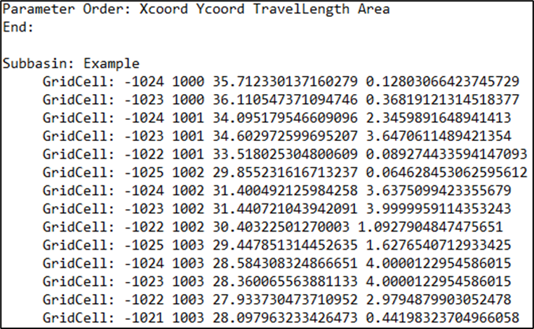
The gridded representation of the watershed must contain the following four items:
- X-coordinate of the cell centroid,
- Y-coordinate of the cell centroid,
- Travel Length, and
- Area
HEC-HMS version 4.4 (or later) should be used to create this gridded file. An example of this process can be found here: Applying Gridded Precipitation to a Non-Georeferenced Project - Structured Discretization.
An example of this gridded data, using the SHG system with 2000 meter x 2000 meter grid cells, is shown below.


Variable Parameter Method
The “Variable Parameter” method can be used to allow both Tc and R to change as excess precipitation rates increase or decrease. Anticipated increases and decreases in translation time and/or attenuation can be simulated with excess precipitation-dependent Tc and R relationships. When used during extreme event simulations, this allows the unit response to vary. The runoff response achieved with the Variable Parameter method has been shown to achieve results that are similar to those of much more complex two-dimensional routing methods in a fraction of the computational time (Bartles, 2016).
Additional discussion regarding this method, including means by which Variable Clark parameters can be estimated for ungaged locations in California, can be found here: Bartles and Meyersohn (2023). A tutorial demonstrating the usage of Variable Tc and R relationships can be found here: Applying the Variable Clark Unit Hydrograph Method.