PDF
Download PDF
Download page New Features.
New Features
HEC-RAS 6.2 Released
Major Features
- Horizontal Variation in Manning's n Values (Beta)
Spatial variation in Manning's n values will be extracted horizontally along the face of 2D cells. A composite n value based on face elevation is used for the Face: Manning's n-Elevation property table.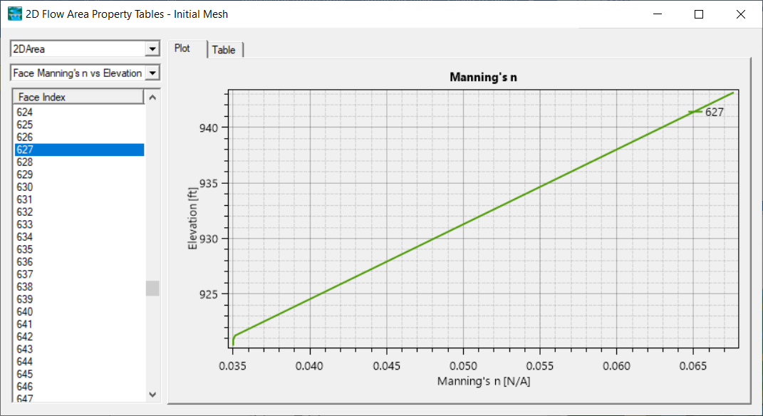
- Inundation Mapping - Render Mode improvements
Changes to the mapping engine now provide a capability to weight the interpolated water surface based on the face depth. This greatly improves rain on grid inundation mapping.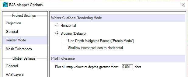
- USGS Terrain Download
The USGS has made data for the United States available for download through the National Map Viewer. In an effort to simplify the process of utilizing elevation data provided as part of the USGS 3DEP, HEC-RAS Mapper provides the capability to "automatically" download terrain data.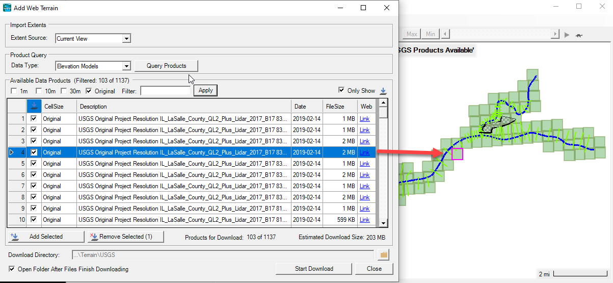
- Sediment Rating Curve Analysis Tool
The Hydraulic Design Editor includes a Rating Curve Analysis Tool. This tool can download sediment data from the USGS and apply a range of statistical analyses (e.g. bias corrections, stationarity analyses, piecewise linear regression, hysteresis analysis, gradation trends). This tool helps sediment modelers develop statistically defensible sediment rating curves.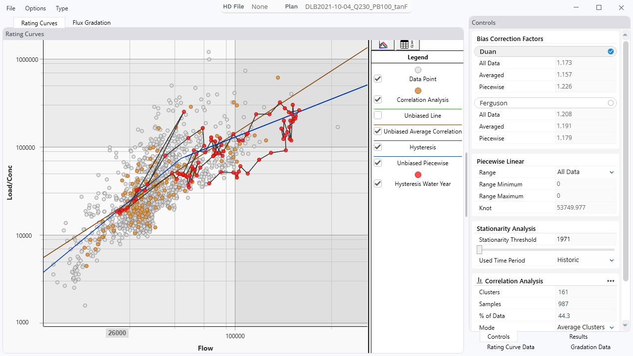
This video describes and demonstrates the capabilities of an alpha version of this tool (before the automatic import). - Speed Improvements
Significant speed improvements were made to Diffusion-Wave Equation (DWE) and minor improvements were made to the Shallow Water Equation (SWE) solvers. Several parts of the code were optimized including the matrix assembly, face and node velocity interpolations, Courant calculations, gradient operators, etc. - New Floodplain Deposition Methods (Rouse-Diffusion)
The 1D Sediment model added a new, non-uniform, floodplain deposition method. The Rouse-Diffusion method uses the Rouse Distribution to determine the fraction of each grain class that is high enough in the water column to transport into the floodplain and an analytical diffusion equation to compute depositional decay farther away from the channel. This method can build natural levees and avoids some of the difficult numerical artifacts of the veneer method (or ignoring floodplain deposition).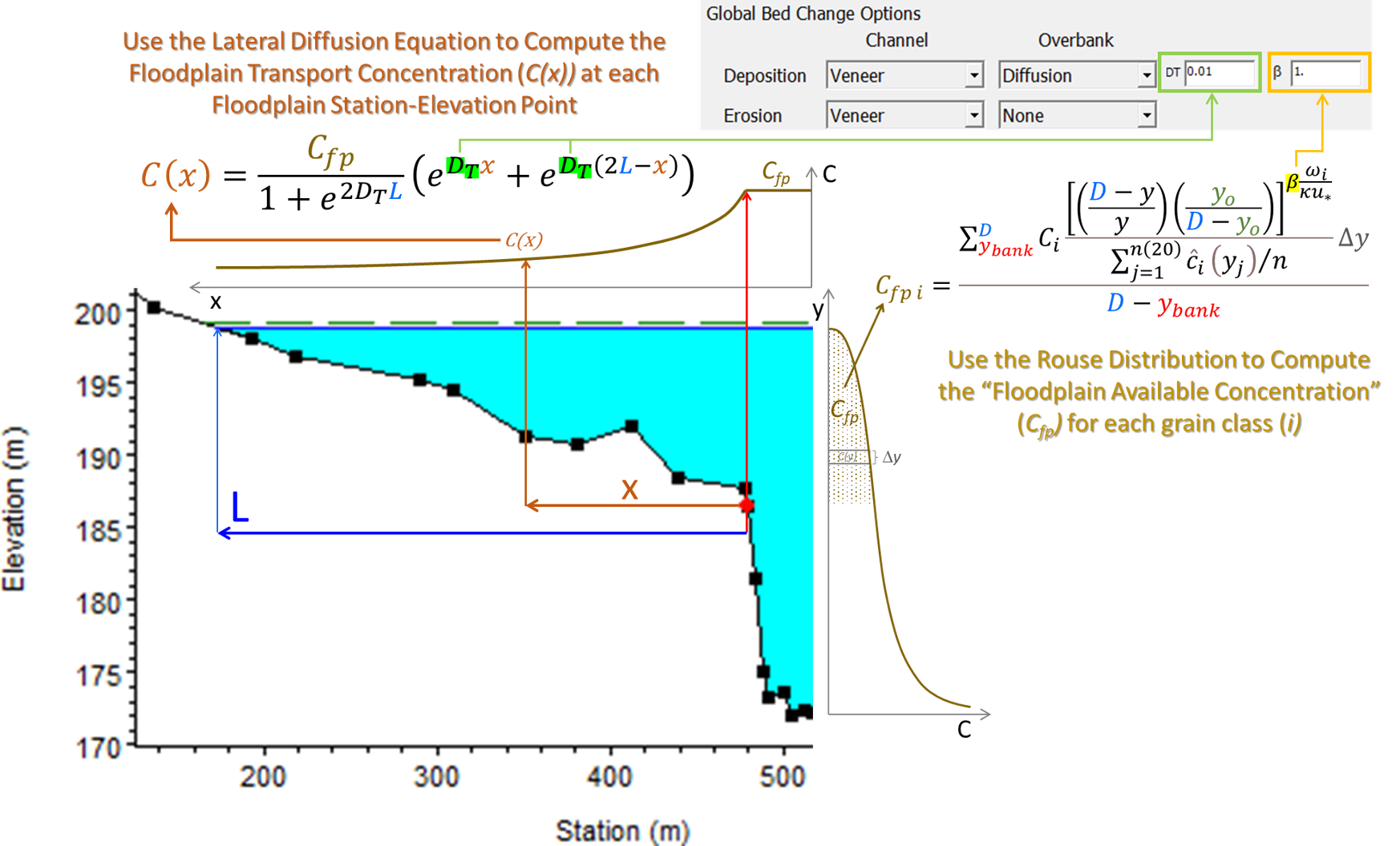
- Create Multiple Maps
This option allows you to create multiple stored maps for publishing results to a library of maps.
- Lava (Alpha)
HEC has added a heat balance and a vertically-averaged, "cooling-Bingham" approach to lava flow.
An animation of an example application is here. - Unsteady Riprap Analysis
HEC modified the riprap calculator to work with unsteady flow simulations. - 2D Bridge Stability
The simplified approach for including bridges in 2D meshes using 1D bridge curves has been improved. The method adjusts the bottom friction along the faces along the bridge to match the flow from the 1D bridge curves based on the head and tail water surface elevations. Unlike the previous approach in Version 6.1, the new approach preserves the advection and mixing terms and doe snot enforce the flow distribution based on conveyance. The new method in Version 6.2 has been found to be significantly more stable and robust compared to the approach in Version 6.1. - Snapshot Feature
This feature allows the user to view HEC-RAS results before a simulation is complete by taking a "Snapshot" of the of the results. The feature has been improved significantly and is really easy to use. - North Arrow is now available to display in RAS Mapper from the Options menu item for the General Project Settings.
Minor Improvements
- Applications Guide is now online - Example projects on various features using HEC-RAS are provided.
- HEC-RAS 2D Class is now online - Video presentations, demos, and workshop materials for the 2021 1D/2D Advanced Modeling with HEC-RAS class are provided.
- Guides and Tutorials page is now online - This is a catch-all help page for how to use HEC-RAS. Includes instructional videos and reference documents to take your modeling to the next level.
- 2D Sediment Restart Capability
- 1D and 2D Sediment Capacity Ratio Boundary Condition
Users can apply a scaling ratio to the Equilibrium Load boundary condition. This factor increases or decreases the load relative to the equilibrium load at the upstream cross section, making sensitivity analysis easier by over loading or under loading the model. For example, a Capacity Ratio of 1.1 brings 10% more sediment than the equilibrium load into the model and 0.9 brings in 10% less.
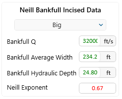
- Automatic Bankfull Hydraulics in Riprap Calculator
Users can now run a separate bankfull steady flow profile and select it in the Riprap calculator. The Riprap calculator will populate the bankfull hydraulics for the Neill scour method automatically.

- Downwind Transport Energy Slope Method
The sediment model added a new energy slope method for the transport functions that uses the slope of the energy grade line between the current and downstream cross sections. This performs better than the current methods in some head-cut and steep transition models in early testing. - 2D DSS Sediment Load Boundary Condition
Version 6.2 can use sediment load time series (by grain class) from DSS. This feature was available in 1D in previous versions, but is connected to 2D in this version. - Can now create maps of max datasets in result summary output inside of RAS Mapper.
- SA/2D Connection/2D Bridge result plots in RAS Mapper can now plot more than one result at a time.
- Can now edit elevation control point elevations inside the high/low ground terrain modification editor
- Raster calculator can now use generic raster layers and additional 2D map output as variables.
- Can now add precipitation layers to Layer Values in RAS Mapper.
- Hydrograph plotter now displays flows for individual gate openings.Improved speed of importing polygon and groundline modifications using the shapefile importer.
- Shapefile importer no longer allows import of multipart polygons as they are not supported in HEC-RAS.
- Added list of omitted features to Shapefile import dialog.Improved rendering times of large datasets in RAS Mapper, especially datasets with many structures.Improved initial load times in RAS Mapper for 2D datasets.
- Terrain line modifications will need to be migrated to version 6.2. HEC-RAS will attempt to migrate the lines automatically but manual adjustment may be required.