Snowmelt Forecasting – Upper Susquehanna River
Disclaimer: The United States Army Corps of Engineers has granted access to the information in this model for instructional purposes only. Do not copy, forward, or release the information without United States Army Corps of Engineers approval.
Workshop Data
Project Files
Download the Initial Project Files here. Unzip in the C:\CWMS_Class directory. CWMS 3.5 was used to create the workshop files and instructions.
HEC-HMS version 4.12 was used to create this tutorial. You will need to use HEC-HMS version 4.12, or newer, to open the project files. HEC-HMS can be downloaded here.
Background
The Upper Susquehanna River is defined as the Susquehanna River above the confluence with the Chemung River, which is just south of Waverly, NY. Elevations within the Upper Susquehanna River watershed range from a high of approximately 2,700 feet (NAVD 88) in the Catskill Mountains of New York to 730 ft at the Chemung River confluence. The slope of the Upper Susquehanna River is approximately 2.5 feet per mile (ft/mi) with some portions exceeding slopes of 10 ft/mi.
Wide and extensive flood plains are located at various reaches along the Upper Susquehanna River. Major population centers within the Upper Susquehanna River watershed include Binghamton, NY and the Endicott – Johnson City – Vestal, NY area. However, there are numerous other areas that situated along the Susquehanna River and other major tributaries. Communities situated within the Upper Susquehanna River watershed are prone to floods at any time of the year.
Significant floods have developed in the summer and fall months due to tropical storms (September 2004), intense thunderstorms (June 2006), and in the winter and spring months due to rapid snowmelt (March 1936). Due to the size and shape of the Upper Susquehanna River watershed, major floods can rapidly develop due to widespread storms that in turn lead to synchronized flood hydrographs originating in the Susquehanna River headwaters, Chenango River, and Tioughnioga River.
Snow Modeling
An HEC-HMS model of the Upper Susquehanna River watershed was created for use in a Corps Water Management System (CWMS) implementation. The Upper Susquehanna River watershed can accumulate a sizable snow pack during the winter months (generally December to March), particularly in higher elevation areas. Snow water equivalents (SWE) in excess of 5 inches in March are typical. While these SWE accumulations are not as extreme as some western watersheds, elevated temperatures combined with high wind speeds and voluminous rainfall can occur at any time of the year. These conditions can lead to rapid melting of the snowpack and flood conditions, as was the case during the devastating March 1936, January 1996, and March 2005 flood events.
The temperature index method was used to simulate snow accumulation and melt processes. This method is based upon SNOW-17 (Anderson, 1973, 2006). Within this method, air temperature is used as a proxy for the energy available for heating or melting the snowpack. While this method is relatively simple, it is incredibly flexible, easily adjusted through model calibration, and has seen wide use throughout the U.S. to design and operate water supply and flood risk management infrastructure.
Snow data collected by the Baltimore District consists of approximately weekly samples in the watersheds upstream and coincident with Whitney Point and East Sidney Dams. Measurements at each site include snow depth, SWE, and an approximate visual snow coverage. Operations personnel travel to multiple locations, collect three unit columns of snow, measure/weigh the contents, and the results are averaged to determine the values which are relevant to the operation of flood control projects. Also, output from the Snow Data Assimilation System (SNODAS) is collected and converted to subbasin-average SWE time series.
Objective
Today is Tuesday, January 3, 2017. So far, the winter of 2016-2017 has been a typical year within the Upper Susquehanna River watershed. Moderate snow accumulations have been recorded within the watersheds upstream of Whitney Point and East Sidney dams. Smaller SWE accumulations have been reported in the lower elevation valleys along the major streams, like the Susquehanna River itself.
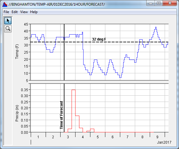
However, a significant storm event is anticipated to pass through the area later today. The National Weather Service (NWS) Middle Atlantic River Forecast Center (MARFC) is predicting that 3 to 5+ inches of precipitation will fall within the next 24 hours with a high degree of reliability. Depending upon the storm track and timing with an incoming cold front, precipitation may fall as snow or rain. The forecasted precipitation and temperature at Binghamton, NY (which is located in the Upper Susquehanna River watershed), is shown in the following figure.

Concerns have been raised by Emergency Management personnel that rapid melting of the existing snowpack combined with the forecasted precipitation may lead to potential flooding. As such, you have been asked to produce inflow forecasts to the two USACE owned and operated dams within this watershed (Whitney Point and East Sidney Dam) in addition to the downstream communities to assist with reservoir and emergency operations.
In this workshop, you will use features within HEC-HMS to perform forecasts that account for snow accumulation and melt processes. You will then calibrate the HEC-HMS model using information within the lookback period to predict possible impacts to in-lake and downstream communities during the forecast period.
The following major tasks will serve as an outline for the workshop:
- Compute the Winter_wSnow (M0X0) HEC-HMS forecast alternative and view results.
- Calibrate snowmelt parameters.
- Calibrate other precipitation-runoff parameters.
The goal is to achieve a Nash-Sutcliffe Efficiency score greater than 0.75 for the lookback period at three observed data locations: Cincinnatus, WhitneyPoint_IN, and EastSidney_IN.
Spend approximately 30 minutes per task to accomplish this workshop within the time allotted.
Tasks
Task 1: Compute the Snowmelt HEC-HMS Forecast Alternative
Task 2: Calibrate Snowmelt Parameters
Task 3: Calibrate Other Precipitation-Runoff Parameters
Solution Files
Project Files
Download the Solution Data here if you would like the watershed and forecast with the full solution.