HEC-HMS version 4.11 was used to create this tutorial. You will need to use HEC-HMS version 4.11, or newer, to open the project files.
Project Files
If you are continuing from Parameterizing the Magat River Basin Modelyou can continue to use your current project files. Otherwise download the initial project files here:
HEC-HMS includes utilities to import and manipulate gridded data from a variety of gridded data sources. Common gridded data formats include NetCDF, HDF, and GRIB. In this example, Global Precipitation Measurement (GPM IMERG) precipitation data has been downloaded from NASA's Goddard Earth Sciences Data and Information Services Center (GES DISC). For more information on downloading data from the GES DISC site refer to the NASA GES DISC Downloader Example.
Generate a Clipping Shapefile
A shapefile will be used to clip the gridded data on import.
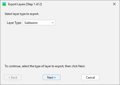
In HEC-HMS, select GIS | Export Layers. On the first step of the Export Layers wizard select the Subbasins Layer.
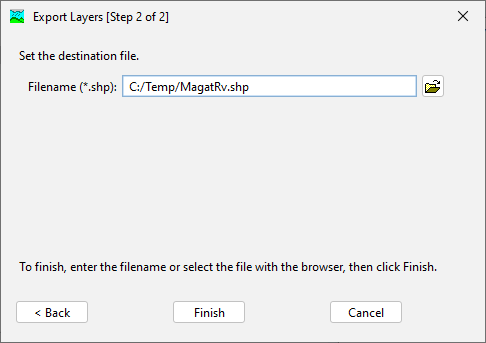
On the second step of the Export Layers wizard save the shapefile as MagatRv.shp. The file will be saved to the location specified.
In HEC-HMS, select File | Import | Gridded Data | Importer.
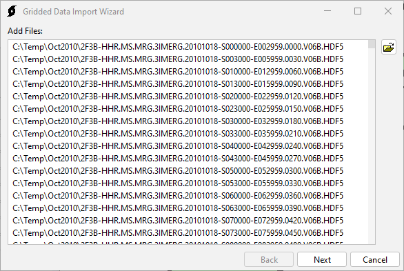
On the first step of the Gridded Data Import Wizard, select all of the HDF5 files in Oct2010.zip. Click Next.
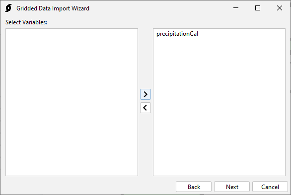
On the second step of the wizard, select the precipitationCal variable.
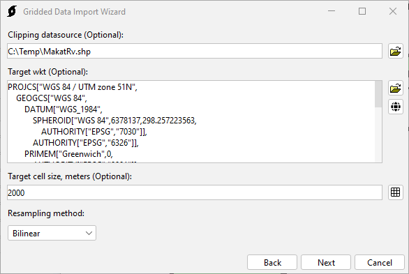
On the third step of the wizard, set the clipping datasource to MagatRv.shp, set the target WKT to UTM 51 North, set the target cell size to 2000 m, and set the sampling method to Bilinear.
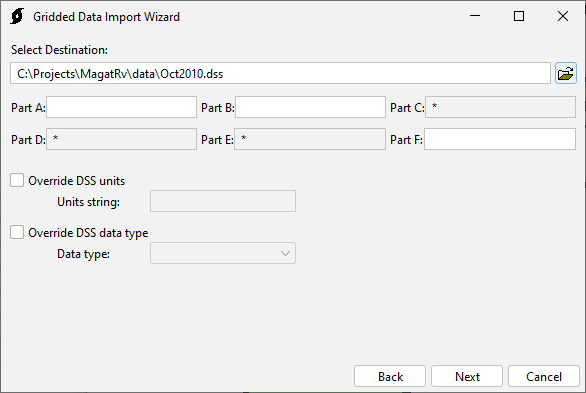
On the fourth step of the wizard, specify the destination HEC-DSS as <MagatRv Project Directory>/data/Oct2010.dss.
Click Next to import the data. Once the data is imported the wizard can be closed.
Create Gridded Precipitation Data
In HEC-HMS, select Components | Create Component | Grid Data.
In the Create A Grid Data dialog, name the grid data Oct2010.
Click Create to create the grid data.
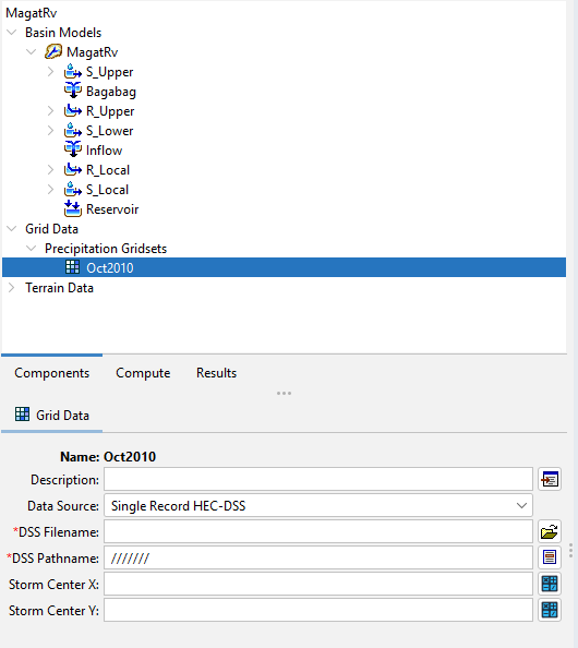
In the Watershed Explorer, select the Oct2010 node in the Grid Data tree.
In the Component Editor for the grid data, specify the DSS filename as <MagatRv Project Directory>/data/Oct2010.dss.
For the DSS pathname, select ///PRECIPITATION/18OCT2010:0000/18OCT2010:0030//.
Click the project Save button. The gridded precipitation has now been linked.
Create Oct2010 Meteorologic Model
In HEC-HMS, select Components | Create Component | Meteorologic Model. Name the model Oct2010.
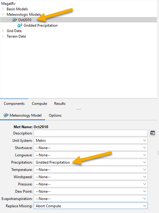
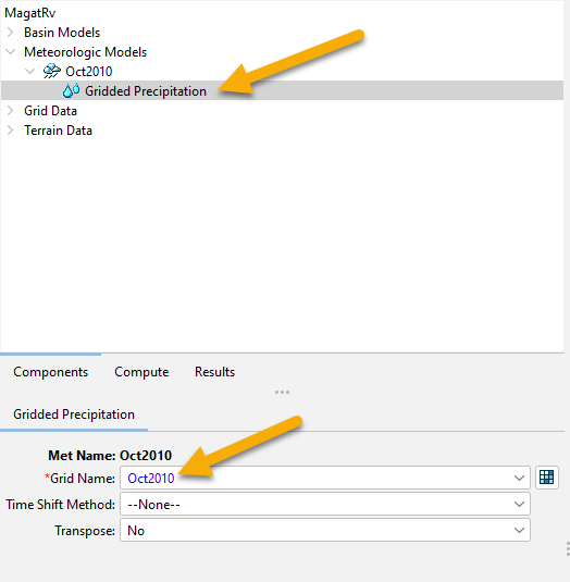
In the Watershed Explorer, browse to the Oct2010 Meterologic Model node. In the Component Editor set the precipitation method to Gridded Precipitation.
In the Watershed Explorer, select the Gridded Precipitation node for the Oct2010 Meteorologic Model. In the Component Editorset the grid name to Oct2010.
Summary
Precipitation data was imported to an HEC-DSS file and Grid Data. A meteorologic model was created with gridded precipitation data.