Background
This tutorial provides an example application of the new Record Extension functionality. The record extension analysis uses data from a site with a long period of record to extend the flow dataset at a nearby site with a shorter period of record. Appendix 8 of Bulletin 17C provides background on the conditions for using record extension techniques (England et al, 2019):
“Record augmentation is attractive when two conditions are met. First, the record available at the site of interest is relatively short. And, there is a nearby longer record site whose flood series is highly correlated with the flood series at the short-record site. Then the longer record can be used to effectively extend the record at the short-record site employing the cross-correlation between floods at the two sites. The recommendation is that record augmentation be considered whenever the cross-correlation > 0.80 and the short-record site is less than 20 years. It may be useful even when the short-record site exceeds 20 years. In any case, a minimum of 10 years concurrent years of record are needed at the two sites considered.”
In this example, the gage location of primary interest is USGS 14211010, Clackamas River near Oregon City. The gage contains approximately 20 years of data from 2001-2020, but nearby gages with more years of data will be used to extend the record. A previous tutorial Using a Correlation Analysis to Select a Suitable Nearby Gage for Record Extension used a correlation analysis to decide which gages are best suited for record extension. The Clackamas River at Estacada gage is the primary long-term site for this analysis. To identify potential candidate sites, the USGS NWIS mapper (https://maps.waterdata.usgs.gov/mapper/index.html) was used to find gages geographically nearby with fairly comparable drainage areas. See below for a summary of the datasets.
Note that the Clackamas River at Clackamas gage, USGS ID 14211000, has streamflow records from 1963-1983. This site is very close to the Oregon City site, with a difference in drainage area of less than 1%. For the sake of this example, this site is assumed not to exist for simplicity. If this dataset were used, the best process would be to first extend the record at Oregon City using the Clackamas gage data. A simple drainage area ratio would be applied, since the difference in area is so small. Then, the Estacada gage would be correlated with the Oregon City data from 1963-1983 and 2002-2020 to perform the record extension. This would boost confidence in the record extension and likely allow for a longer data extension.
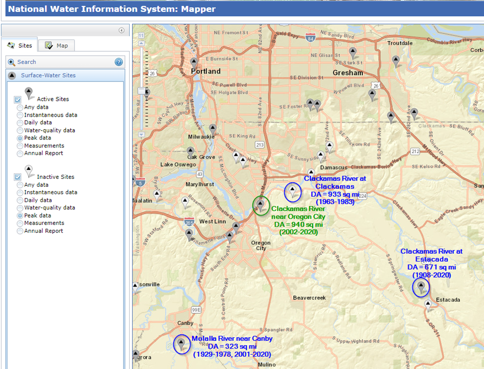
USGS ID | Gage Name | Drainage Area (sq mi) | Period of Record |
|---|
14211010 | Clackamas River near Oregon City | 940 | 2001-2020 |
14211000 | Clackamas River at Clackamas | 933 | 1963-1983 |
14210000 | Clackamas River at Estacada | 671 | 1908-2020 |
14200000 | Molalla River at Canby | 323 | 1929-1978,
2001-2020 |
Objectives
In this workshop, you will gain experience performing a record extension of annual peak flow data. Specifically, you will import and inspect data, fit an LPIII distribution to a short record, extend the short record using record extension techniques, fit an LPIII distribution to the extended record, and compare the flow-frequency results. HEC-SSP version 2.3. The following major tasks will serve as an outline for the workshop:
- Task 1. Create a new HEC-SSP Study and Import Data
- Task 2. Inspect the Data
- Task 3. Use Bulletin 17C Procedures to Fit an LPIII Distribution to the Short Record
- Task 4. Perform the Record Extension
- Task 5. Fit an LPIII Distribution to the Extended Data and Compare the Results
- Drainage Area Ratio vs MOVE.3 Record Extension
Spend approximately 20 minutes per task to accomplish Tasks 1 - 5. If time allows, read through Task 6.
Continue to Task 1. Create a new HEC-SSP Study and Import Data.