HEC-EFMSim is a detailed simulation software. The normal progression of tasks in EFMSim modeling is spatial setup, informatics, ecology, and application.
Contents:
This figure details the progression.
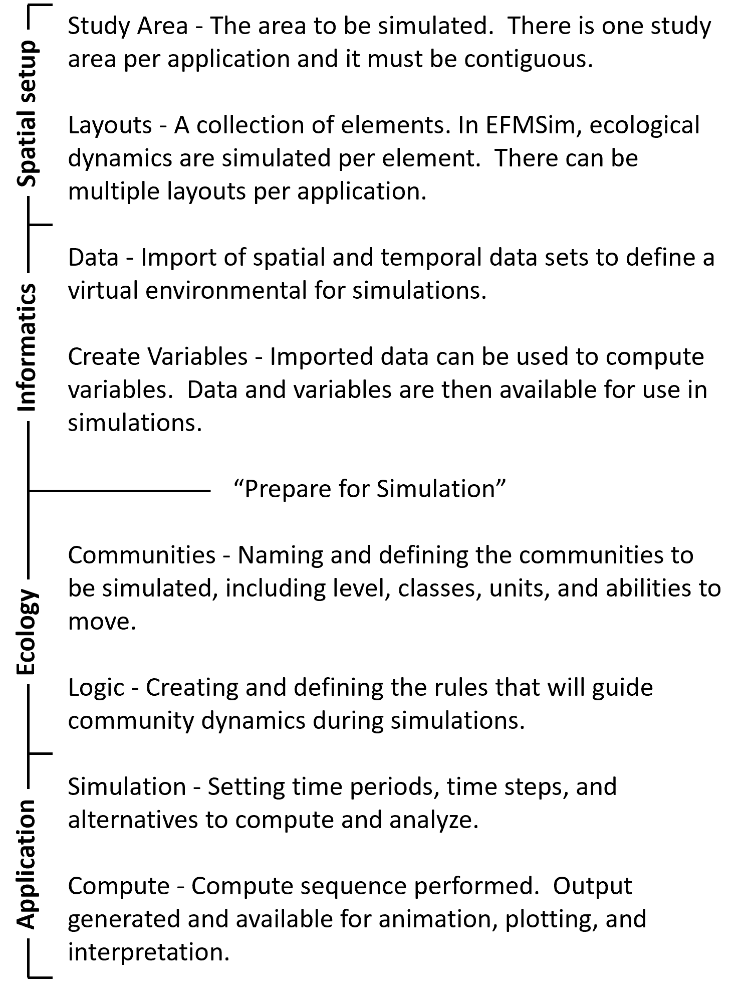
Spatial Setup
Spatial setup involves defining the study area to be simulated. There is only one study area per EFMSim model and it must be contiguous.
Layouts are discretizations of the study area. Each layout is a collection of elements that wholly fills the study area. Elements are the finest spatial resolution considered during simulations.
Using a jigsaw puzzle as an example, the study area would be the outer edge of the puzzle, a layout would be the collection of puzzle pieces, and an element would be one of the pieces.
There can be multiple layouts per EFMSim model. There are typically many elements per layout. This hierarchy of study area – layouts – elements defines the spatial construct of the model.

Back to the top
Informatics
Informatics is fundamentally about data. Spatial data resources are rapidly expanding as remote sensing and computing capabilities advance. EFMSim relies heavily on temporal sequences of spatial data
imported to EFMSim for use in simulations. Those data, with variables computed directly based on those data, define the virtual environment used during simulations. For example, spatial-temporal data
that reflect conditions in year 2020, conditions in year 2050, and conditions in year 2100 would shape three different virtual environments thereby allowing modelers to simulate the ecological effects
of different future scenarios. This approach allows for modeling of diverse spatial and temporal matters of interest, including changes in land use, land management, water management, and water quality.

Back to the top
Ecology
Ecological details are incorporated as users set the communities to model and the logic that will guide community dynamics during simulations. Each community in an EFMSim model has a name, level,
and community variable and associated unit. Communities are typically split into size classes, which allow for simulations of different dynamics per community-class, or comm:class for short.
Mobile communities also have movement parameters such as how fast they can move, which can be specified per comm:class. EFMSim also allows users to define project units, which can be used to
track and report different aspects of the community. For example, a “trees” community might have a community variable of height, which means that “trees” would grow in terms of height.
Project units could be used to translate that height to related variables such as carbon sequestration, board feet timber, or biomass of leaves available as forage.


Back to the top
Application
Once spatial setup is done, data prepared, and ecological information entered, application of EFMSim occurs via the software’s simulation module. Simulations are given a name,
start date, end date, and time step. Alternatives with details such as which communities to simulate and which layout to use are added to simulations and then computed individually
or sequentially. Results are written to the database that underlies the software and is tightly connected to the embedded GIS such that results are available for animation,
plotting, and interpretation at a variety of spatial scales (from element to study area) and ecological aggregations (from comm:class to all).
Back to the top