HEC-RTS is a comprehensive data acquisition and hydrologic modeling system for short-term decision support of water control operations in real time. The following is a description of some of the major
capabilities of HEC-RTS.
CWMS
CWMS (Corps Water Management System) and HEC-RTS (Real-Time Simulation) are the same program, except that the CWMS has access to the CWMS Oracle database and HEC-RTS does not. This is done with
a software switch, so both are the same code. HEC-RTS obtains data stored in HEC-DSS files and CWMS obtains data from HEC-DSS and CWMS Oracle. Both programs share the same directory structure, so a watershed can
be built and used with either program, except HEC-RTS will not be able to access data from CWMS Oracle.
Back to the top
Forecasting
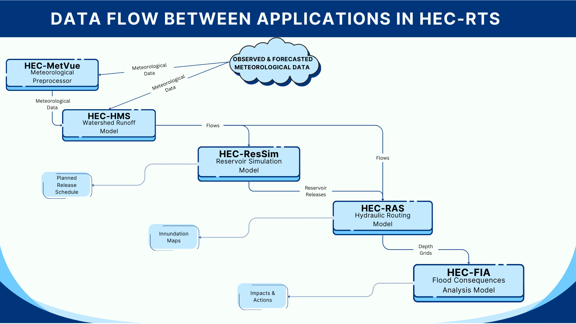
HEC-RTS provides support for operational decision making by forecast simulation modeling using any combination of the following models. Rainfall-runoff modeling with HEC-HMS based on gaged or radar-based
precipitation, Quantitative Precipitation Forecasts (QPF) and other future precipitation scenarios provides forecasts of uncontrolled flows into and downstream of reservoirs. Simulation of reservoir operations
with HEC-ResSim provides operational decision information for the engineer. The river hydraulics program HEC-RAS computes river stages and water surface profiles for these scenarios.
An inundation boundary and depth map of water in the flood plain can be calculated from the HEC-RAS results using RAS Mapper. The impacts of different flow alternatives are computed by HEC-FIA. The
user-configurable sequence of modeling software allows engineers to evaluate operational decisions for reservoirs and other control structures, and view and compare hydraulic and economic impacts for various “what
if?” scenarios.
Back to the top
Interface
HEC-RTS shares a common interface with the Watershed Analysis Tool (HEC-WAT), the “planning” version of CWMS or HEC-RTS, and several other HEC software applications. The common framework allows
models to be used in either a planning alternative application or for real-time forecasting and decision making. The framework provides mechanisms for HEC-RTS to communicate directly with the modeling programs,
running as independent processes.
Back to the top
Georeferencing
HEC-RTS and the models share a common geo-referenced "Desktop Pane" that can have an Internet map background, such as Google® or Bing®. Each model registers and draws geo-referenced model objects on the map panel,
such as a reach, cross-section, subbasin, junction, etc. When a user selects one of those objects, HEC-RTS sends a message to the model and the model displays the dialog box associated with that object. For example,
by selecting one of the green cross section lines on the map, the user can bring up the HEC-RAS Geometry Editor for that cross section.
Back to the top
Actions/Reports
HEC-RTS has an "Actions/Reports" panel. From this panel, when a model is selected, that model displays a list of commands (buttons) that can be performed by that model in that state, such as compute, set loss
rates, change routing coefficients, etc. Selecting a command brings up the appropriate software application editor or performs an action. Similarly, the Reports panel displays a list of commands for reports
(plots, tables) from each of the software applications, which are displayed when selected.
Back to the top
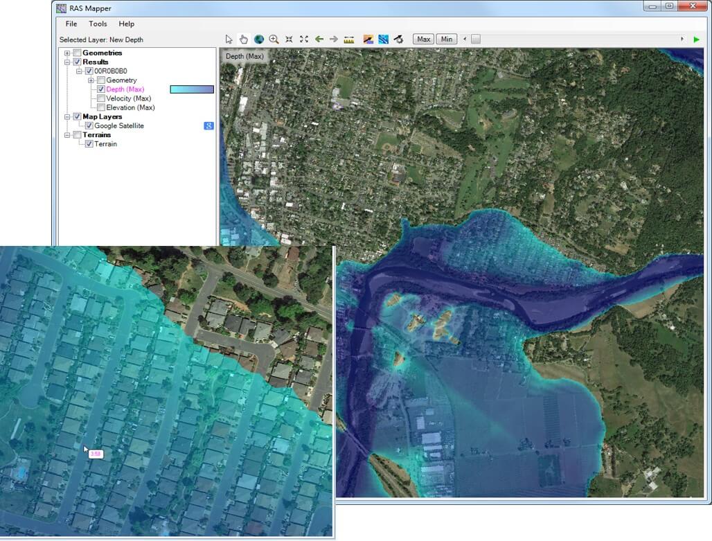
RAS Mapper
The integration with HEC-RAS and RAS Mapper provides a mechanism for computing flood inundation maps in real-time using forecasted flows from HEC-HMS and HEC-ResSim. The maps will display flood depths and
boundaries based on various rainfall scenarios and/or reservoir operations or other alternatives that can affect stages and flow. The maps are overlaid on an Internet map background (chosen by the user) or a
geo-referenced photo, allowing the user to zoom in and see detailed depths. RAS Mapper can write selected maps in a Google® format that can be placed on a server and seen in the field on an iPad or smart phone.
Back to the top