Download PDF
Download page v4.11.0 Release Notes.
v4.11.0 Release Notes
Initial beta release:
Final version release:
New Features
Gridded Precipitation Storm Center Parameterization
The Precipitation Gridset shared component data has been enhanced to allow you to parameterize storm center x coordinate and y coordinate. A calculate option has been included that allows you to automatically calculate the coordinates where the greatest precipitation accumulation occurs over the temporal extent of the gridset. This feature supports the gridded storm transposition feature that is also included in this release.

For more, see Transposing Gridded Precipitation.
This feature was funded by the USACE General Investigations program. Initial code implementation was performed by Lauren Coe and Tom Brauer. Documentation and testing was performed by Lauren Coe, Greg Karlovits, and Tom Brauer.
Gridded Storm Transposition
The Gridded Precipitation method in the meteorologic model has been enhanced to allow transposition of gridded precipitation. The storm center of the gridded precipitation record is transposed to the new location specified in the gridded precipitation component editor.
For more, see Transposing Gridded Precipitation.
This feature was funded by the USACE General Investigations program. Initial code implementation was performed by Tom Brauer. Documentation and testing was performed by Lauren Coe, Greg Karlovits, and Tom Brauer.
Gridded Storm Optimization
New capability has been added to the Gridded Precipitation method and Optimization Trial to allow optimization of storm center coordinates. The optimization framework can iteratively transpose the storm center to maximize flow or stage at a specified location in the basin model.
For more, see Optimizing Gridded Precipitation.
This feature was funded by the USACE General Investigations program. Initial code implementation was performed by Tom Brauer. Documentation and testing was performed by Lauren Coe, Greg Karlovits, and Tom Brauer.
Gridded Storm Uncertainty and Stochastic Storm Transposition
New capability has been added to the Gridded Precipitation method and Uncertainty Analysis to allow gridded precipitation datasets and storm center coordinates to be sampled, and for summary statistics of each random sample to be captured. This works similarly to the Optimization Trial, without having a directed goal of maximization or minimization of an objective function. Randomly selecting precipitation gridset, x coordinate, and y coordinate can be used to achieve stochastic storm transposition (SST). For more, see https://youtu.be/AZMGbCK4d7w.
Additionally, Parameter Value Sample paired data were created for storm x and y coordinates so that the Specified Values sampler can be used in the uncertainty analysis:
This work was funded by FEMA through the Future of Flood Risk Data (FFRD) initiative. Initial code implementation was performed by Tom Brauer. Documentation and testing was performed by Greg Karlovits, and Tom Brauer.
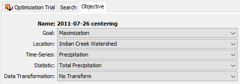
Optimization of Total Storm Precipitation
The option to optimize a Precipitation time-series and Total Precipitation statistic was added to the Optimization Trial Objective Function. The use case is to allow the user to determine storm properties that maximize precipitation volume over an element, independent of any hydrologic processes. This would allow for optimization of any storm parameters that change the amount of precipitation applied to an element, for example HMR-52 parameters or gridded precipitation centering.
This work was funded by FEMA through the Future of Flood Risk Data (FFRD) initiative. Code, documentation, and testing was performed by Greg Karlovits.
Spatially Variable Hypothetical Storm
The storm depth for the Hypothetical Storm meteorologic model can now be entered or calculated from precipitation-frequency grid separately for each subbasin. The user can select either the Variable By Subbasin or Uniform For All Subbasins option from the Spatial Distribution menu.

If Variable by Subbasin option is selected, the point depths can be entered separately for each subbasin in the subbasin meteorology editor or calculated automatically by HEC-HMS. HEC-HMS will average grid cell values in the frequency-precipitation grid within each subbasin's extent.

For more, see Applying New Hypothetical Storm Enhancements and Applying the Hypothetical Storm Met Model in HEC-HMS.
Precipitation-Frequency 10-min, 30-min, and 3-day depths
The Frequency Storm method now allows users to add 10 minute, 30 minute, and 3 day depths for creating a balanced hyetograph.
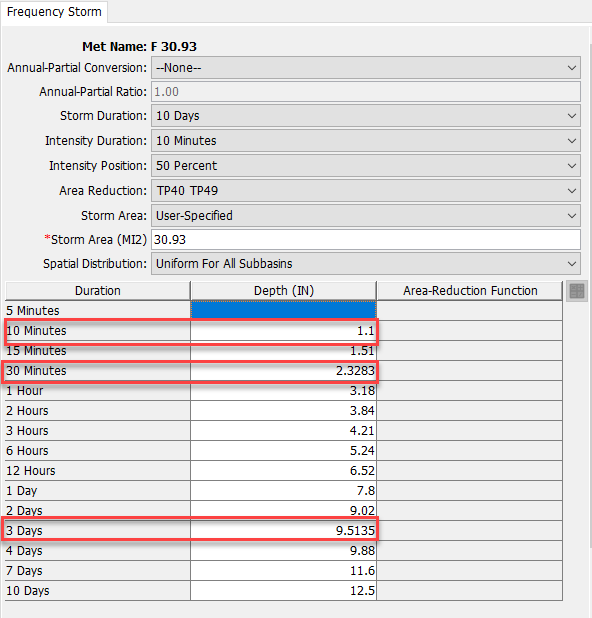
In HEC-HMS version 4.10 and below, the 10 minute and 30 minute depths were computed internally using the Hydro-35 equations. When migrating HEC-HMS projects version 4.10 and below, HEC-HMS will compute 10 minute and 30 minute depths and add them to the component editor using the Hydro-35 equation which will maintain the same frequency storm in 4.11. If users have the Storm Duration set to 4 days or higher and migrating to 4.11, HEC-HMS will compute the 3-day depth based off a log interpolation between the "unreduced" 2-day depth and 4-day depth. The inclusion of this 3-day depth will likely create a slightly different balanced hyetograph than the balanced hyetograph created in prior versions. Benchmark tests have shown differences less than 1% but could vary depending on the watershed. More information on how the Frequency Storm computes its depths is described here.
Precipitation Frequency Depths Tabular Export
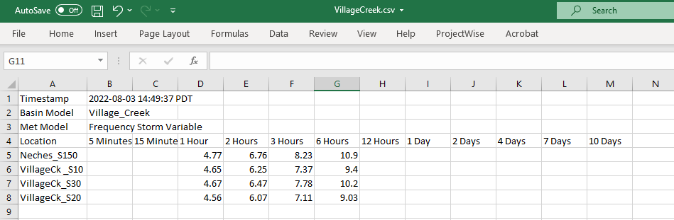
The Frequency Precipitation Calculator was added in v.4.10 and is used to quickly calculate average precipitation depths and apply new precipitation depths at either the watershed or subbasin level. These calculated values are displayed in the Precipitation-Frequency Depths Table Dialog. New features have been added to the Frequency Depths Table Dialog including an Edit and Export button. The Export button will allow the unedited precipitation depths to be exported to a CSV file. The user can enable editing to change precipitation depth values in the table with the Edit button. Editing values will disable the Export button.
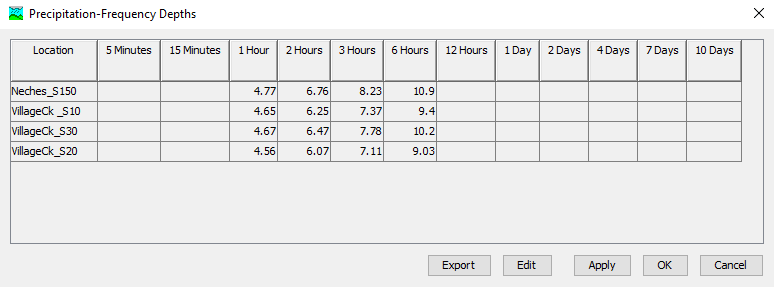
The generated CSV file will contain a header with pertinent model data and the Precipitation-Frequency Depths Table. Header data will include a timestamp of when the depths were exported, Basin Model name, and Meteorologic Model name.
Interpolated Longwave Radiation, Humidity, and Atmospheric Pressure
Interpolation methods were added for longwave radiation, humidity, and atmospheric pressure within the meteorologic model. These options interpolate between one or more gaged locations and create a series of grids (if interpolating over a gridded domain) or time-series at point locations (if interpolating over a non-gridded domain). The interpolation methods include inverse-distance squared, inverse-distance, nearest-neighbor, and bilinear. The interpolated result is cached to disk in an HEC-DSS file. The cached result is accessed on subsequent computes unless a parameterization change occurs invalidating the cache and triggering a re-compute. The time-series gages that are selected for interpolation must be parameterized with a valid longitude and latitude.
This feature was funded by the Northwestern Division (NWD) - Columbia River office, the Mississippi River Geomorphology & Potamology (MRGP) program, and the USACE Arid Regions Work Unit within the Flood and Coastal Systems Research and Development (R&D) program. Initial code implementation was completed by Mike Bartles. Documentation and testing was completed by Mike Bartles and Matt Fleming.
Stefan Boltzmann Longwave Radiation
This new meteorologic method allows for the estimation of longwave radiation based upon the air temperature and relative humidity of the location in question (i.e., grid cell and/or subbasin). This method is described within TVA (1972) and Follum et al, (2015).
This feature was funded by NWD, MRGP, and Arid Regions R&D Work Unit. Initial code implementation was completed by Mike Follum, Dan Hamill, Mike Bartles, and Tom Brauer. Documentation and testing was completed by Mike Bartles, Dan Hamill, Avital Breverman, Paul Ely, and Tom Brauer.
Reduced Solar Constant Shortwave Radiation
This new meteorologic method allows for the estimation of shortwave radiation based upon the elevation, slope, and aspect of the location in question (e.g., grid cell and/or subbasin). This method is described within TVA (1972) and Follum et al, (2015).
This feature was funded by NWD, MRGP, and Arid Regions R&D Work Unit. Initial code implementation was completed by Mike Follum, Dan Hamill, Mike Bartles, and Tom Brauer. Documentation and testing was completed by Mike Bartles, Dan Hamill, Avital Breverman, and Tom Brauer.
Precipitation Index Humidity
This new meteorologic method allows for the estimation of relative humidity based upon precipitation of the location in question (e.g., grid cell and/or subbasin). This method is described within Anderson (2006) and Follum et al, (2015).
This feature was funded by NWD, MRGP, and Arid Regions R&D Work Unit. Initial code implementation was completed by Mike Follum, Dan Hamill, Mike Bartles, and Tom Brauer. Documentation and testing was completed by Mike Bartles, Dan Hamill, Avital Breverman, Paul Ely, and Tom Brauer.
Barometric Atmospheric Pressure
This new meteorologic method allows for the estimation of atmospheric pressure based upon the elevation of the location in question (e.g., grid cell and/or subbasin). This method is described within Anderson (2006) and Follum et al, (2015).
This feature was funded by NWD, MRGP, and Arid Regions R&D Work Unit. Initial code implementation was completed by Mike Follum, Dan Hamill, and Mike Bartles. Documentation and testing was completed by Mike Bartles, Dan Hamill, Avital Breverman, and Paul Ely.
Atmospheric Pressure, Wind Speed, Humidity, Longwave Radiation, and Net Shortwave Radiation Spatial Results
Atmospheric Pressure, wind speed, humidity, longwave radiation, and net shortwave radiation have been added to the list of available spatial results when using the energy budget snowmelt method.
This feature was funded by NWD, MRGP, and Arid Regions R&D Work Unit. Initial code implementation was completed by Mike Bartles. Documentation and testing was completed by Mike Bartles and Matt Fleming.
Optimization Trial Improvements
Relative Simplex Tolerance
For the Simplex search method in the Optimization Trial, the option to assess convergence based on relative tolerance was added. Previously, the convergence was assessed based on absolute tolerance, which checked to see if the absolute difference between objective function values at nodes of the simplex were all below the specified criterion. This meant that the magnitude of the objective function affected the determination of convergence. For example, the user would need to set a larger value for tolerance for the Sum of Squared Errors objective function than for the RMSE function for the trial to converge in a similar number of iterations because values of the SSE objective function are generally orders of magnitude larger than for RMSE. Now the user can choose the Relative tolerance criterion, which compares relative differences between the nodes of the simplex, and is less sensitive to the magnitude of the objective function values. For general use, the Relative option is preferred, but the default option is Absolute for backwards compatibility.
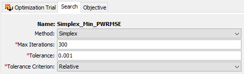
For more, see Apply Simplex Search Optimization Trials.
This work was funded by the HH&C Science and Engineering Technology (SET) program. Code, documentation, and testing was performed by Greg Karlovits.
Run Final Iteration of Optimization Trial with Best Parameter Set
In prior versions of HEC-HMS, the results shown for a Trial reflected the last evaluation of the search prior to termination, which was generally not the best parameter set. This meant that Element summaries such as a Graph view or Summary Table did not reflect the optimized parameter set. In HEC-HMS 4.11, when the search terminates because it has converged, the Trial will run one final evaluation of the model using the optimized parameter set, which updates all Trial results to reflect a simulation using that best parameter set. This ensures that all results in an Optimization Trial are finalized using the optimized parameter set shown in the Optimized Parameters table.

This work was funded by the HH&C Science and Engineering Technology (SET) program. Code, documentation, and testing was performed by Greg Karlovits.
Optimization Results Reported by Evaluation Instead Of Iteration
Previously, values for the objective function and parameters were stored to the project DSS file (and shown in the results graphs and tables) for each iteration based on the last evaluated parameter set for that iteration. This tended to understate the variability in the parameters and objective function value as the search was reaching convergence, and fail to communicate the range over which a Trial was searching parameters. Now, the results are stored and displayed for each evaluation (every time the model runs with a new parameter set) so that the actual variability in the parameters and objective function are visible as the search proceeds.

This work was funded by the HH&C Science and Engineering Technology (SET) program. Code, documentation, and testing was performed by Greg Karlovits.
Parameter Scale Factor Optimization
The option to use scale factors on all subbasins in an optimization trial already exists for a number of processes and methods, such as Deficit and Constant loss. The framework is being expanded to include other processes and methods to facilitate parameter optimization in complex watershed models. Scale factor optimization was enabled for the three Simple Canopy parameters: Initial Storage, Max Storage, and Crop Coefficient and for Clark transform Time of Concentration and Storage Coefficient.

Parameter Scale Factor Optimization was funded by the HH&C Science and Engineering Technology (SET) program. Code, documentation, and testing was performed by Greg Karlovits.
Differential Evolution Optimization Minimum Iterations Setting
An additional setting was added to the Differential Evolution optimization search method to require the search to complete a minimum number of iterations regardless of if it hits the termination (convergence) criterion. This can avoid the situation where the user has to set a very tiny tolerance in order to get desirable results. If a search terminates due to converging, and the user raises the minimum number of iterations above the current number of iterations, the search will pick up where it left off and continue until it hits at least the new minimum iteration limit.

This feature was funded by the HH&C Science and Engineering Technology (SET) program. Code, documentation, and testing was performed by Greg Karlovits.
Ensemble Compute
A new compute type called the Ensemble Compute has been added to HEC-HMS. Ensemble modeling is a process whereby multiple base models are created and simulated in a collective fashion to predict an outcome. Each base model may include different basin configurations, modeling methods, parameter sets, initial conditions, and/or boundary conditions. As long as the base models are diverse and independent, the prediction error of the base models decrease when the ensemble modeling approach is used. While the ensemble model is composed of multiple models, it acts and performs as a single model. Currently, the ensemble compute can be made up of different simulation runs or forecast alternatives. The time-series output types that are currently compatible within an ensemble analysis in HEC-HMS include outflow, reservoir elevation, incremental precipitation, LWASS, SWE, cumulative outflow, cumulative precipitation, moisture deficit, and air temperature.
The below plot shows how flow computations at a basin element vary for a specific event depending on the precipitation data source used (AORC, MRMS, Interpolated Gages, etc.). The plot shows the individual ensemble traces (simulation run results) as well as several statistical time-series computed from the traces (mean, max, min, etc.).
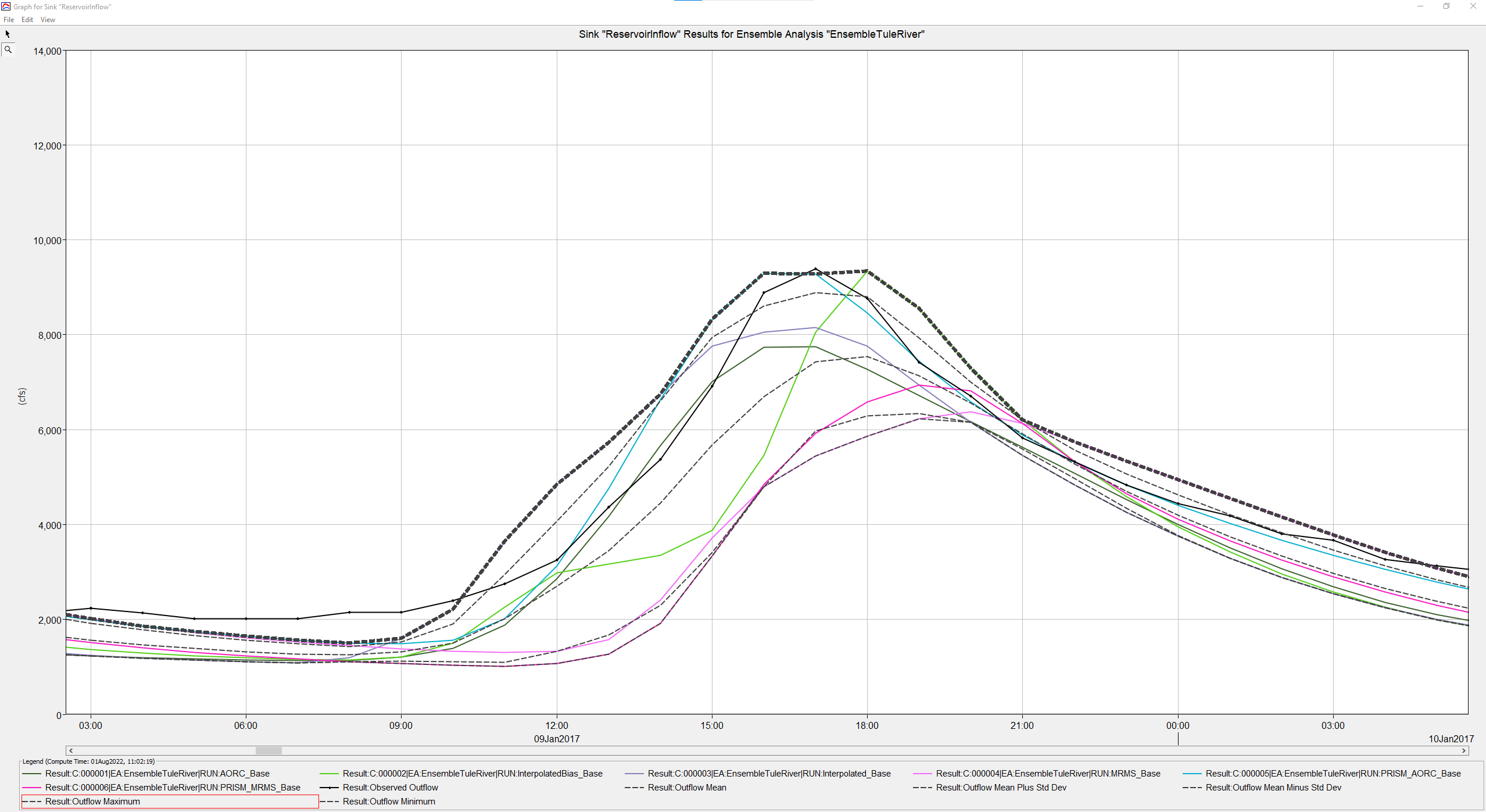
For more, see Ensemble Analysis Simulations in HEC-HMS.
Initial code and implementation were done by Josh Willis. Testing and documentation were done by Matt Fleming and Josh Willis.
Snow Modeling Improvements
Temperature Index Zonal Editors
The new Temperature Index Zonal Editor allows for editing of Snow Method parameters that utilize Temperature Index or Gridded Temperature Index methods within a Forecast Alternative. Parameter adjustments can be made within defined zones (groups) of elements, or to individual elements within the zones.
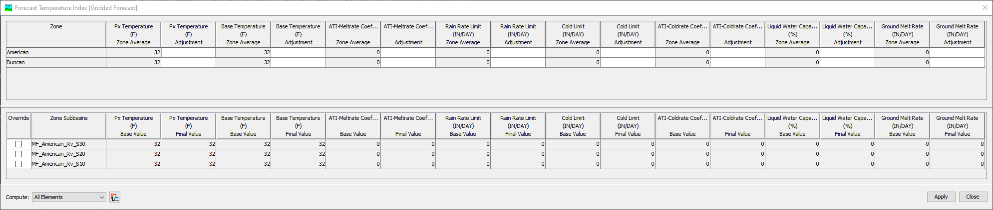
For more information, see Adjusting Parameters for the Forecast.
This feature was funded by the Corps Water Management System (CWMS) National Implementation Program. Initial code and implementation were done by Daniel Black. Testing was done by Matt Fleming and Mike Bartles.
Hybrid / Radiation-derived Temperature Index (RTI) Snowmelt
The Hybrid snowmelt method (also known as the Radiation-derived Temperature Index, RTI, method) utilizes additional factors to compute a proxy energy available for snowmelt. This representative energy is derived from radiation computations that include simple estimates of net shortwave and longwave radiation (Follum et al, 2015). Net shortwave radiation includes topographic, cloud cover, vegetation, and albedo effects while net longwave radiation includes contributions from the air, vegetation, cloud cover, and approximate snow temperature. Currently, no additional meteorologic boundary conditions are required to use this method within HEC-HMS. In order to compute net shortwave radiation, topographic shading must be preprocessed. These topographic shading computations are only required once and can be reused in subsequent simulations. Outputs that are computed by this method include:
- Liquid Water at the Soil Surface (LWASS)
- Snow Water Equivalent (SWE)
- Effective Albedo
- Liquid Water Content (LWC)
- Antecedent Temperature Index
- Heat Deficit
- Radiation Temperature
A tutorial and guide detailing the relative sensitivity of these parameters for a location in Colorado can be found here: Evaluating Gridded Hybrid/RTI Snowmelt Parameter Sensitivity.
A tutorial and guide demonstrating the use of the Gridded Hybrid snow method can be found here: Gridded Hybrid: Upper Truckee River.
A presentation describing this new snow method can be found here: http://youtube.com/watch?v=TLCKDxQUhyY
This feature was funded by the USACE Arid Regions work unit within the Flood and Coastal Systems Research and Development program. Initial code implementation was performed by Dan Hamill, Mike Bartles, Avital Breverman, Bill Scharffenberg, and Mike Follum. Documentation and testing was completed by Dan Hamill, Mike Bartles, and Avital Breverman.
Energy Budget Snowmelt
A new Energy Budget snowmelt method was added for version 4.11. This new method is based on the Utah Energy Budget (UEB) Model developed at Utah State University by Tarboton et al (1995). A single layer is used within this method to represent the energy stored in the snowpack and the upper part of the ground which has a thermal interaction with the snowpack. The snowpack has a depth-averaged temperature which is related to the stored energy. An energy budget is computed between the snowpack surface and surface temperature, then the surface temperature is used to compute the change in the snowpack energy content over a time interval. The change in snow water equivalent is affected by the energy content for the time interval.
Boundary conditions that are required to use this method include:
- Shortwave Radiation
- Longwave Radiation
- Precipitation
- Air Temperature
- Wind Speed
- Atmospheric Pressure
- Relative Humidity
Outputs that are computed by this method include:
- LWASS
- SWE
- Albedo
- Snow Pack Energy
- Snow Pack Temperature
- Snow Surface Temperature
- Snow Pack Condensation
- LWC
- Snow Depth
A tutorial and guide detailing the relative sensitivity of these parameters for a location in Colorado can be found here: Evaluating Energy Budget Snowmelt Parameter Sensitivity.
A tutorial and guide demonstrating the use of the Banded Energy Budget snow method can be found here: Energy Budget: Swamp Angel Study Plot, Colorado.
A tutorial and guide demonstrating the use of the Gridded Energy Budget snow method can be found here: Gridded Energy Budget: Upper Truckee River.
A presentation describing this new snow method can be found here: http://youtube.com/watch?v=TLCKDxQUhyY
This feature was funded by the Northwestern Division - Columbia River office. Initial code implementation was performed by Mike Bartles, Avital Breverman, Paul Ely, and Bill Scharffenberg. Documentation and testing was completed by Mike Bartles, Avital Breverman, Matt Fleming, Jeremy Giovando, and Chandler Engel.
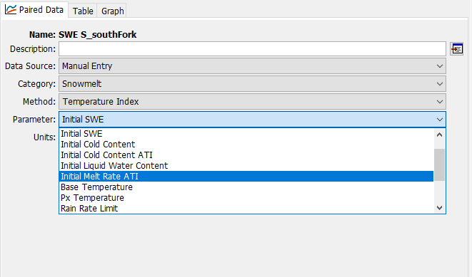
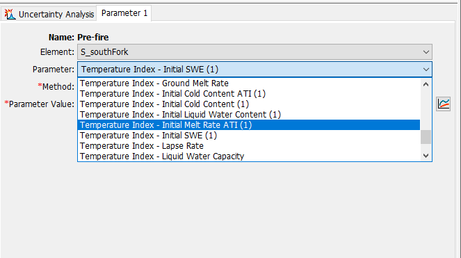
Expanded Parameter Selection for Uncertainty Analysis Snowmelt Parameter Value Samples
The Uncertainty Analysis compute type had a limited selection of snowmelt parameters to select from when using the Specified Values option. The full suite of snowmelt parameters can now be selected in the Paired Data and as a Parameter in the Uncertainty Analysis.
Dynamic Surface and Gridded Dynamic Surface
Dynamic Surface and Gridded Dynamic Surface were added to the Surface method for post wild-fire conditions. This method allows the infiltration rate to change over time to account for changes to the infiltration as a result of watershed burn and recovery. Infiltration rates eventually will return to their pre-fire rates. There are currently three infiltration methods within Dynamic Surface to limit and recover infiltration rates: Pak & Lee, User-Specified, and None option. The purpose of this new surface capability is to model the recovery of infiltration after a fire to which directly impacts runoff generation. This method can be used for predicting flash floods over burned watersheds and debris flows.
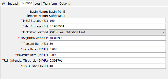
For more information, see Applying the Dynamic Surface | Pak and Lee Method for Post-wildfire Hydrologic Modeling.
This feature was funded by the USACE Arid Regions work unit within the Flood and Coastal Systems Research and Development program. Initial code implementation was performed by Jay Pak and Paul Ely. The Component Editor Interface was performed by Nick Van and David Ho. Global Editor Interface was performed by David Ho. Documentation and testing were completed by Jay Pak and David Ho.
2D Diffusion Wave and Sediment Transport Enhancements
Multiple 2D Meshes within a Single Basin Model
The ability to use multiple 2D meshes within a single basin model was added within version 4.11. This allows for the use of the 2D Diffusion Wave transform within multiple subbasins in a single simulation.
This work was funded by FEMA through the FFRD initiative. Initial code implementation, documentation, and testing was performed by Mike Bartles.
2D Solver
Both the HEC-RAS and HEC-HMS team make continual improvements to the shared 2D Solver and this release contains the latest rollup of fixes and improvements. These changes were made to improve computational speed, stability, and accuracy of the 2D results. As such, you may notice subtle changes in hydraulic results. Please see the latest HEC-RAS v6.4 Release Notes for further details.
Initial code implementation and documentation for this feature was performed by Alejandro Sanchez and Mike Bartles. Testing was completed by Alejandro Sanchez, Jay Pak, Natasha Sokolovskaya, and Mike Bartles.
Separate Output for Linear Reservoir Baseflow Layers
The Linear Reservoir Baseflow method allows users to set up to 3 subsurface layers when modeling baseflow. Results from each baseflow layer can now be viewed in the Results tab in HEC-HMS and in the output HEC-DSS file.


This feature was funded by the Omaha District, USACE (NWO). Initial code implementation was completed by David Ho. Documentation and testing was completed by David Ho and Matt Fleming.
Sediment Modeling Improvements
Sediment Volume Time-Series Type
When sediment is enabled for a basin model and a simulation is computed, sediment load computations are converted to sediment volume estimates using user-specified unit weights for each soil texture type (clay, silt, sand, etc.). The time-series results are written to disk and can be viewed on the Results tab under the Sediment node. The Sediment Volume Time-Series results were added by Josh Willis. Documentation and testing were completed by Josh Willis and Jay Pak.

Changes were made to the C-Part of the DSS pathname when writing sediment volume time-series to an output HEC-DSS file. "SEDIMENT-COMBINE" entries which used to represent incoming sediment loads are now written as "SEDIMENT LOAD-COMBINE" to differentiate from "SEDIMENT VOLUME-COMBINE". The C-Part name "SEDIMENT-OUT" used to represent outgoing sediment load but now are written as "SEDIMENT LOAD-OUT" to differentiate from "SEDIMENT VOLUME-OUT".

Bulk Flow Time-Series Type
When sediment is enabled for a basin model and a simulation is computed, bulk flow time-series computations are performed. To create the bulk flow time-series, the total sediment volume time-series is converted to an instantaneous value and combined with the flow (water-only) time-series. In watershed where high rates of erosion are computed, the bulk flow time-series can be noticeably larger than the flow (water-only) time-series. The bulk flow results are written to disk and can be viewed on the Results tab under the Sediment node. The Bulk Flow Time-Series results were added by Josh Willis. Documentation and testing were completed by Josh Willis and Jay Pak.

Sediment Global Summary Table
When sediment is enabled for a basin model, sediment load and sediment volume results are computed during simulation runs. Total sediment load and total sediment volume results can be seen in the Global Summary Table for each element. Additional sediment volume results, such as a breakdowns of each soil texture type (clay, silt, sand, etc.), are stored within the .results text file. The Global Summary Table was updated by Josh Willis. Documentation and testing were completed by Josh Willis and Jay Pak.

Sediment Delivery Ratio Transport Potential Method
The Sediment Delivery Ratio (SDR) method was added to the Sediment Transport Potential method option for simulating the amount of sediment/debris by user-specified delivery ratio for each grain size. The Sediment Delivery Ratio method requires the ratio of each grain class (Clay, Silt, Sand, and Gravel for the Clay Silt Sand Gravel System/Clay, Silt, Sand, and Gravel, Cobble, and Boulder for the AGU 20 System). A Ratio number is greater than 1 represents an erosional situation, a Ratio number less than 1 represents a depositional situation, and a Ratio number equal to 1 is an equilibrium situation.
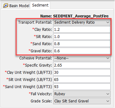
The Sediment Delivery Ratio (SDR) method was funded by the USACE Arid Regions work unit within the Flood and Coastal Systems Research and Development program. The initial code implementation was done by Paul Ely. Documentation was written by Jay Pak. Testing was done by Jay Pak. The Component/Global Editor Interface was performed by Danial Black, Nick Van and David Ho.
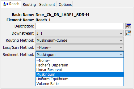
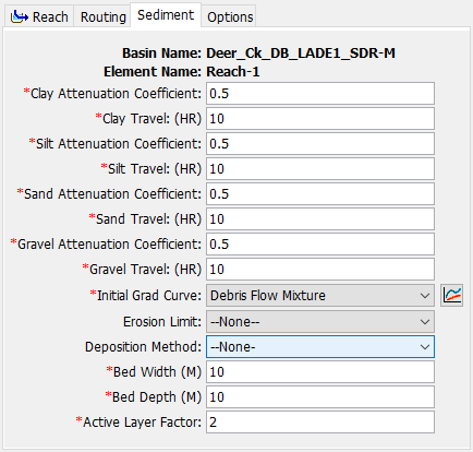
Muskingum Sediment Reach Routing Method
The Muskingum method was added to the sediment reach routing method option to route sediment/debris through the stream reach. For each time interval, available sediment is calculated from the upstream sediment, local erosion, and local deposition. The available sediment in each grain size class is routed using the Muskingum routing parameters, Attenuation Coefficient and Travel time. This allows sediment of different grain sizes to move at different speeds and allow for attenuation through the reach.
The Muskingum method was funded by the USACE Arid Regions work unit within the Flood and Coastal Systems Research and Development program. The initial code implementation was done by Paul Ely. Documentation was written by Jay Pak. Testing was done by Jay Pak. The Component/Global Editor Interface was performed by Danial Black, Nick Van and David Ho.
Rule-Based Reservoir Operations and Related Features
A simple implementation of rule-based reservoir operations has been added to HEC-HMS. The method extends the Outflow Structures reservoir method and allows the reservoir to operate moveable gates to achieve simple rule-based objectives. For the reservoir's release logic to be able to modify releases, the General Outlet and Gated Orifice Outlet have been added to the rule-based reservoir operations outlet types (see below). Spillway gates now have the option to be moved by an operations controller, or by time-series or pattern (see below).

Using rule-based operations requires the user to define at least one operations zone, which houses a set of homogeneous rules. Each zone is defined by a maximum elevation, which is a new Paired Data curve type, the Daily Elevation Pattern.

Each zone has a storage objective, which is also a new Paired Data curve type, the Storage Pattern.

Zones may have zero or more rules (they may be set to only operate to the storage pattern, or rule curve, with no other rules for operation.)

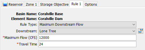
There are 10 types of rules, including Maximum Auxiliary Release, Maximum Downstream Flow, Maximum Main Release, Maximum Rate Flow Change, Minimum Auxiliary Release, Minimum Downstream Flow, Minimum Main Release, Specified Auxiliary Release, Specified Downstream Flow, and Specified Main Release (plus a "None" rule.) Note that any method that has a downstream flow target requires specification of an element downstream of the reservoir that is used as a target for the operations. The reservoir releases must iterate in order to achieve a target downstream flow, and this can be computationally expensive.
The two new outlet types are the General Outlet, a simple tool for reproducing reservoir outflow rating curves in water control manuals, and the Gated Orifice Outlet.


Previously, broad-crested and ogee spillways had the option to use sluice or radial gates, except only with a fixed opening setting that does not vary throughout the simulation. The ability to operate those gates was enabled in v4.11.

Disclaimer
The rule-based reservoir operations feature in HEC-HMS is intended to model simple reservoir operations. Watersheds with complex reservoir operations, including multiple control points, reservoirs operated as systems, and so on, should be modeled with a more appropriate tool such as HEC-ResSim.
For more information, see Rule-Based Option for an HEC-HMS Reservoir Element.
The rule-based reservoir operations method and related features were funded by the USACE Risk Management Center. The initial implementation and user interface code was completed by Bill Scharffenberg, Paul Ely, Greg Karlovits, and Nick Van. Documentation was written by Greg Karlovits. Testing was performed by Matt Fleming and Greg Karlovits.
Drainage Area Added to the Basin Element Inventory Table
Cumulative drainage areas are now displayed in the Basin Element Inventory Table, and the formatting of the table has been generally improved.

Global Editor sorting relabeled from "Hydrologic" to "Watershed Explorer"
The hydrologic order can be rearranged in the Watershed Explorer. This can be considered a "user-specified" hydrologic order. HEC-HMS does not store multiple states for the HEC-HMS-determined hydrologic order, and the user-specified hydrologic order. The "Hydrologic" order in the global editors has been relabeled to "Watershed Explorer" to indicate that the global editor will simply be replicating the order of the elements in the Watershed Explorer.

Display global editors outside of desktop program setting
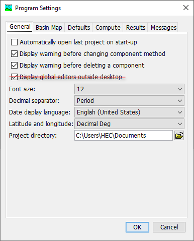
The "Display global editors outside desktop" program setting has been removed. With the new global editor framework global editors are always displayed outside the desktop.
Warnings Generated When Flow or Precipitation Ratios Are Applied
Flow and Precipitation Ratios are a setting on the Simulation Run that change the input precipitation or generated discharge from elements. Occasionally a ratio is set and forgotten about, resulting in unexpected model results. HEC-HMS did not indicate to the user during a Simulation Run that they were being applied. Now, HEC-HMS throws a warning when ratios of any kind are applied.


DSS 7 Migration Utility
A DSS 7 Migration Utility has been added to the Tools | Data | DSS | Migrate to DSS 7 menu. If a project is open, the utility will default to the project directory. The utility will attempt to migrate all files in a directory and its subdirectories to HEC-DSS version 7. HEC-DSS version 7 has demonstrated increased performance over HEC-DSS version 6 and HEC-DSS version 7 is more serviceable by the HEC-DSS team. We recommend migrating your projects to HEC-DSS version 7.

The initial code implementation completed by Thomas Brauer with review by Nick Van. Documentation was written by Thomas Brauer. Testing was performed by Matt Fleming.
User Interface Themes
A user interface theme selections has been added to the Tools | Program Settings, General tab. The standard theme is "System" which gives a look and feel consistent with the operating system. Alternative themes include "Dark" and "Light." The dark theme is shown in the image below.

Vortex Image Exporter
Vortex's Image Exporter utility has been added to the HEC-HMS user interface. The utility exports gridded data from DSS format to tiff and asc formats. This tool is accessible by navigating to Tools | Data | Image Exporter. Launch scripts for Vortex utilities are also available when HEC-HMS is closed by navigating to <hec-hms root>/bin/vortex.
Bugs Fixed
The following bugs were present in previous versions and have been fixed within version 4.11.
Snowmelt Parameter Optimization Trials
Support for snowmelt parameters in Optimization Trials was inadvertently removed during the migration of snowmelt methods from the Meteorologic Model to the Basin Model. Snowmelt parameters are now available again within Optimization Trials.
Snowmelt Uncertainty Analyses
Support for snowmelt parameters in Uncertainty Analyses was inadvertently removed during the migration of snowmelt methods from the Meteorologic Model to the Basin Model. Snowmelt parameters are now available again within Uncertainty Analyses. The following snow time series are available as output options in an Uncertainty Analysis: Snow Water Equivalent (SWE) and Liquid Water at the Soil Surface (LWASS). In addition, incorrect upper and lower limits were applied to the snowmelt parameters in the Uncertainty Analysis. The allowable upper and lower limits of the parameters have been corrected.
When performing an Uncertainty Analysis combined with a basin model using the Banded Temperature Index, Gridded Temperature Index, or Energy Budget snowmelt methods, incorrect upper and lower limits were applied to the snowmelt parameters. This bug was caused by the migration of snowmelt methods from the Meteorologic Model to the Basin Model and has been fixed in version 4.11.
When using the Specified Parameter Values Uncertainty Analysis method, the compute type was not sampling from the Paired Data Table for elevation band temperature index parameters. The bug was caused by not having the temperature index parameter values set in the Paired Data Editor Panel class and by references made to the legacy snowmelt methods in the Meteorological Model. This bug has been fixed in 4.11. In addition, Energy Budget and Gridded Hybrid snowmelt parameters can now be selected in the Specified Parameter Values Uncertainty Analysis method.
Subbasin Point Storm Depths would not Clear in Frequency Storm Meteorologic Model
The storm depths in subbasin met model editor for the Frequency Storm would linger even after the spatial distribution of the storm was set to be 'Uniform for all Subbasins'. The editor would then re-populate with the defunct depths when the 'Variable by Subbasin' option was selected again. The error was fixed and the old depths now clear from the editor.
Manual Entry Paired Data Values were not being Saved
Manual entry unit hydrograph paired data curves were not being correctly saved after the modeler created a new paired data object and then manually entered the data. This behavior could have been seen with other paired data types as well. The issue was fixed, the program saves manual entry paired data values.
Aborted Simulations when New Basin Models Contained Subbasin Elements Set to use the None Discretization Method
Basin models were missing the Basin_name.sqlite file when all subbasin elements had the None discretization method selected. This caused aborted simulations. The issue was fixed.
Re-delineating Subbasins that use the 2D Diffusion Wave Transform Method
When re-delineating a basin model that contained at least one subbasin that used the 2D Diffusion Wave transform method, errors were encountered and the delineation process failed. This error has been rectified such that the delineation process works as intended.
Using Reservoir Elements with a Tailwater Option within the CAVI/HEC-WAT Model Linking Editor
When attempting to query the available output from a basin model with one or more reservoir elements that had a tailwater option other than "Assume None" selected, a non-descript error message was thrown. This error was only encountered within the CAVI/HEC-WAT Model Linking Editor. This error has been fixed such that the available output is correctly shown.
Calibration Summary Table Values are Blank When Element Names Contain Commas
Previously, calibration summary statistics were not computed if the basin element names contained commas. This would result in blank values within the calibration summary results table. This omission has been fixed so that calibration summary statistics are computed whether or not commas are present in the basin element names.
Exporting Table to a non *.csv File Resulted in Corrupt File
The Table Export Dialog was modified to limit table export to an *.csv file. The export was fixed to actually create a comma delimited file when *.csv export option is selected. Previously, the values were exported to a tab-delimited file.
Not Including *.crs File with a Precipitation Grid Resulted in Abort with no Message
A clarifying error message was added to both hypothetical storm compute and frequency depth calculator to indicate when a precipitation frequency grid is missing projection *.crs file.
Frequency Precipitation Calculator Aborted with no Message if *.dss File Was Provided as Source for Precipitation Frequency Grid Data
Frequency precipitation calculator was improved to calculate storm depths from grids with *.dss source files.
Reach Characteristics Table Shows As Blank When a non-Reach Element is Selected in the Watershed Explorer
Previously when a non-reach element was selected in the watershed explorer, the reach characteristics table was still accessible and showed up as blank. The logic was corrected to disable access to the reach characteristics table when a non-reach element is selected. This now mirrors the functionality associated with subbasin characteristics.
Subbasin Characteristics Computations are Aborted with Missing GIS Data
Previously, if a subbasin boundary did not intersect with the elevation raster data, subbasin characteristics calculations would immediately abort. Checks have now been added that allow the subbasin characteristics calculations to proceed to completion. There are checks in place for the subbasin boundary being contained within the elevation dataset, the subbasin area being sufficiently large enough when compared to the elevation dataset resolution, and the presence of no-data elevation values within a subbasin boundary. If any of these cases are present, NaN entries are populated in the subbasin characteristics table and a message dialog now appears with a description of why NaN values were computed.
Modified Puls routing method requiring Elevation-Discharge curve
The elevation-discharge functional curve is an optional selection for Modified Puls routing method but the compute would show an error stating the elevation-discharge curve was missing when set to None or when no elevation-discharge curve was present in the model. The issue is fixed where the elevation-discharge input is optional to compute the simulation.
Time-series selection for Uncertainty Analysis not stored
A subset of time-series selected in the uncertainty analysis were not being stored after compute. The code has been updated such that all time-series results selected in the output results dialog are stored after computing the uncertainty analysis.
Meteorologic time-series not selectable in output results dialog
Meteorologic time-series were not selectable in output results dialog in some cases. This typically occurred the first time the output results dialog was opened. Subsequent openings of the dialog allowed for meteorologic results to be selected. This has been addressed so that meteorologic results are always selectable when the are available.
Error 10000 when copying and pasting basin elements
Pasting a copied element would sometimes result in Error 10000. The issue was fixed.
Precipitation grid time shift with non-gridded subbasins
Grid time shifts for precipitation were not being properly applied when working with non-gridded (e.g. Clark) subbasins. Gridded precipitation is typically used in conjunction with gridded (e.g. ModClark) subbasins, which worked without issue. This issue has been addressed such that grid time shifts for precipitation work with both gridded and non-gridded subbasins.
v2.2 project hangs on open
A v2.2 project hung on open when attempting to convert deficit recovery to evapotranspiration. This issue has been resolved allowing the v2.2 project to open.
Connect upstream subbasin to downstream junction for subbasin-split with insert junction setting on
On subbasin split, connect the upstream subbasin to the downstream junction when the insert junctions setting is selected and the subbasin split point is coincident with a reach. Previously the upstream subbasin was connected to the downstream reach rather than the downstream junction.
Switching data source to *.dss for grid data would not save to file
When switching to 'Single Record HEC-DSS' data source from another data source in grid editor, the new data source file name and pathname would not save to disk. The issue has been fixed.
Error 10000 when running a frequency analysis compute
For a frequency ordinate, if the user forgot to specify a meteorologic model or other parameter (i.e. "--None–" was selected) an Error 10000 was generated during compute. Now this is checked prior to compute and a useful error note is displayed in the console.
Old DSS output remained after changing the number of samples and recomputing an uncertainty analysis
Previously, if a user reduced the total sample size and reran an uncertainty analysis, some results from the old run were not overwritten and remained. Logic was added to clean the Uncertainty Analysis DSS output file when changing the total sample size.
Program hangs on open when attempting to forward migrate pre-v4.3 projects with groundmelt pattern in temperature-index snowmelt
The program would hang/freeze on open when attempting to open a pre-v4.3 project in v4.10 or v4.11 if the project included a groundmelt pattern in the temperature-index snowmelt method. This occurred because both the groundmelt pattern migration and the migration of snowmelt from the meteorologic model to the basin model were competing for meteorologic model resources. This issue has been fixed in v4.11.
Incorrect error message displayed with FAO56 shortwave and longwave radiation methods
In some cases the wrong error message was presented when errors were encountered with the FAO56 shortwave or longwave methods.
Selecting a 2D Connection as an Reservoir Auxiliary Connection
In previous versions, 2D Connections were not allowed to be selected as an Auxiliary Connection within a Reservoir element. This issue has been fixed within v4.11.
Global editors not opening for multiple basins with similar names
A global editor would not open for a basin if there was one already open for a basin with a name containing the selected basin's name (e.g. Basin and Basin-1). The issue has been fixed.
Terrain reconditioner stalls at times when a smooth drop buffer is specified
When creating a reconditioned terrain with a smooth drop buffer specified by the user, occasionally HEC-HMS would stall out. A fix was added to help the operation to proceed to completion.
Filtered entries in File Reference Dialog not editable
Filtered reference dialog table entries would not be editable if the filter was applied while a row in the table was selected that's beyond than the filtered table size. This was fixed.
2D Connection description would load to Subbasin description
Description entered for a 2D Connection dialog would load into the subbasin description. This was fixed.
Switching between 2D Connection nodes in different basins would lead to errors
The 2D Connection editor would not update or would cause the program to break if the user switched between two 2D Connection nodes in different basin models. The error was fixed.
Optimization Trial plots, if open, would not update when the objective time-series and statistic were changed
This issue occurred only when the objective plot (or any of the parameter plots) was open, the user changed the objective time-series and statistic, and then the user recomputed an optimization trial. Previously, the plot objective title did not update based on the new objective. The issue has been fixed.
Temperature node was not displayed in results for gridded subbasin
This issue occurred when temperature was computed in the meteorology model, but snow was not being computed in the basin model and the subbasin transform was gridded. Temperature is now displayed in the results if snow is not computed.
Missing Resource for Error 21487
Fixed a missing error resource for Error 21487, switching it to 21451 and updating text to "Gridded or interpolated precipitation must be used for gridded snow melt."
Sediment Results with AGU 20 were not properly calculated
This issue occurred when sediment/debris results were converted from volume to mass in the sediment model. All 20-grain classes for AGU 20 were not converted in volume to mass unit conversion. Sediment mass and volume are now displayed consistently for both AGU 20 and Simple 4 (Clay, Silt, Sand, Gavel).
Incorrect maximum SWE values saved for an uncertainty analysis
The program was not correctly saving the maximum SWE from the computed SWE time-series. The computed SWE time-series was correct, but the wrong maximum SWE was reported in the uncertainty analysis summary table.
Grid to Point tool not correctly computing averages for shapefiles with multiple polygons
The grid to point tool was not computing a separate time series for each polygon in the selected zones shapefile. Now, the program creates a separate time-series for each polygon using the name attribute as the b-part pathname.
Error in Specified ET when compute buffer length is less than simulation time window
Specified ET was being written to one time series for a simulation, but the basin model was retrieving the reference ET from a different time series. Specified ET and the basin model are now working with the same time series.
Rule-Based Reservoir Route method aborts when nothing is changed
Rule-Based reservoir routing will compute 2 or more times to adjust releases when release is based on a downstream flow condition. While checking if release rules were based on downstream flow, the program was only looking at rules for the last storage zone that was used. If nothing has changed, the simulation does not recompute and the last storage zone is not defined. The program was changed to look at release rules for all storage zones to see if there are rules based on downstream flow.
Empty paired data curves causing a fatal error
Selecting an empty paired data curve within the Watershed Explorer and then clicking another component would cause an error and freeze the program. This issue has been fixed and the program correctly handles empty manual entry paired data tables.
Unknown error when a compute had None basin model, meteorological model or specifications
Checks were added to produce a proper error message during compute if 'None' was selected for basin model, met model or specifications in several compute types, including simulation runs, optimization trials, depth-area-analyses, uncertainty analysis and forecast alternatives.
Setting independent parameter to none in uncertainty editor for regression with additive error would not save
The selection of 'None' would not save for the uncertainty analysis with the 'Regression with Additive Error' method selection. The error was fixed.
New checks added to the Bilinear Interpolation method
The bilinear interpolation method would seem like it failed to interpolated point values. New checks were added to stop the interpolation and issue error messages when there are less than three gages selected for interpolation or when the gages do not cover, or bound, all cells in the grid.
Debris Flow does not compute sediment when only one runoff value is above threshold value
A debris flow event is created when runoff is above a threshold value. The event end time was not set correctly when there is only one runoff value above the threshold value. This has been corrected so sediment is computed for an event with only one runoff value above the threshold.
Flaky UI behavior with rule-based reservoir UI
The program occasionally switches to the Zone tab when editing in the Rule tab. The problem has been resolved, and the mentioned behavior is no longer present.
Synchronize Clark transform component editor and global editor changes
Synchronize Clark transform component editor and global editor changes. This includes all Clark transform implementations: Standard, Variable, and Maricopa.
Header - data mismatch when reordering columns within the Global Summary Results Table
When the user changed the column order in the Global Summary Results Table and then performed an action such as sorting the rows alphabetically, the column headers would reset to their default order creating a mismatch between the column headers and the data underneath them. This issue is now resolved.
Synchronize Snow Method Global Editor Changes
When modifying certain parameters or initial conditions in the Snow method global editors, applied changes were not being recognized within the corresponding component editors. This has been rectified within v4.11-beta.12.
Using the Field Calculator to Estimate Snow Method Parameters
Parameter estimates were not being correctly populated when using the Field Calculator within the Snow method global editors. This has been rectified within v4.11-beta.12.
LA Debris EQs 2-5 did not work with a gridded subbasin
This issue occurred when LA Debris EQs 2-5 was used with the gridded transform method like a Mod-Clark method. This has been rectified within v4.11-beta.10.
Correct graph editor window titles for optimization parameter and frequency analysis results
Dialog titles were corrected for the optimized parameter results graph and the frequency analysis graph.
USGS Long Term Model Global Editor
USGS Long Term Model Global Editor was not opening after changing the method. Global Editor for USGS Long Term Model now shows up when selected.
Changing Linear Reservoir baseflow to another baseflow method
A mesh linear reservoir interflow option was added in v4.8. With this addition, bad user-interface code was added that prevented changing from Linear Reservoir baseflow to other baseflow methods. This has been fixed in this version.
Global Editors reflect unit system changes
Previously if a global editor was open and the basin or meteorology unit system was changed, that change would not be reflected in the global editor. This has been fixed in this version.
Use Precipitation Parameters for Regression with Additive Error
When attempting to compute an uncertainty analysis using Precipitation Parameters as the independent variable, the compute would fail. The code was updated so meteorology variables can be used as the independent variable for Regression with Additive Error.
File References table filtering for non-DSS grid
In the File References table, when filtering for grids, the filter would exclude non-DSS gridded data. This has been fixed so that all gridded data sources are included when filtering.
Jython scripting against the Windows-installed version of HEC-HMS
In recent Windows-installed versions of HEC-HMS, some users were unable to pass scripts to HEC-HMS.cmd due to a class not found exception regarding hms.jar. This bug was not observed with portable versions of HEC-HMS. This has been rectified within v4.11-beta.12.
Missing Observed Data plots for maximization goal optimization
Observed Data plots were not being produced for goodness-of-fit types of maximization goal optimization (for example, maximization of Normalized Nash Sutcliffe efficiency.) This has been fixed in v4.11-beta.12.
Units reverting when trying to change for Paired Data
Units were reverting back to the original default units when switching (i.e. if default was metric and switched to USCS, after accepting change, would revert back to metric system units). This has been fixed in v4.11-beta.12.
Global Editors do not track rename
Global editors for the Basin Model and Meteorologic Model and the Subbasin and Reach Characteristics views did not track renames. This has been fixed in v4.11-beta.12.
Attempts to rename a basin or meteorological model to a name that is already in use would remove the basin or meteorological model from the project
Renaming a basin or meteorologic model to a name that is already in use within the project caused the basin or meteorologic model to be removed from the project. This has been fixed in v4.11-beta.12.
Decreasing number of iterations in optimization search sometimes caused unknown error
Unspecified error message when decreasing number of iterations in optimization trials was fixed in v4.11-beta.13.
Automatic removal of empty values when pasting from Excel/CSV/Text causes data misalignment
Any empty values were automatically removed when pasting data from Excel into the program, causing the pasted data to be condensed and misaligned with the correct timestamps. This problem also occurred when copying and pasting from CSV or.txt files. This has been fixed in v4.11-beta.13.
Broken functionality in Uncertainty Analysis results graphs
Results graphs for Uncertainty Analysis had broken functionality including Zoom To All, View | Hide/Show Legend, Plot Properties, and Configure Plot Layout. This functionality has been restored in v4.11-beta.13.
No error message for incorrectly defined objective function time window
Time window not within the allowable range for the objective function in optimization trial resulted in exiting compute with an unspecified error message. Checks were added to notify the appropriate error message.
Point/Zoom mouse adapter in results plots
Fixed issue in results plots where the zoom/pointer mouse functionality does not persist between computes.
Observed sediment load was not accessible from the results tab
Observed sediment load was added to results in v4.11-beta.13.
Missing values when using Output Control
When using the output control feature to increase the time step of written results, in some cases the entire output record was not written. This has been fixed in v4.11-beta.14.
Basin and Met Models did not track renames of Gridded Data and Paired Data
When a Gridded Data or Paired Data is renamed, the elements inside Basin and Met models failed to register the new gridded data or paired data name. This has been fixed in v4.11-beta.14.
Graphs did not open from basin map
When right-clicking on an element to display results graph, the graph did not open. This has been fixed in v4.11-beta 14.
Graph results shown as out-of-date
After a simulation is computed, a graph would show that the results were out-of-date. This has been fixed in v4.11-beta 14.
Sediment results differ with different buffer size
Changing the simulation buffer size caused changes in the sediment results. An error in how the sediment time series was set for small buffer sizes was fixed in v4.11-beta 14.
Changing simulation time window caused differences in debris flow calculations
Changing the simulation time caused differences in calculated debris flow. This issue was fixed in v4.11-beta 14 by resetting the accumulated rainfall for a debris flow event to zero when direct runoff went to zero.
Simulation fails when using ratio of precipitation
When the ratio of precipitation is different from 1.0, the simulation would sometimes fail. This issue has been fixed in v4.11-beta 14.
Results graph for subbasin with a 2D connection wouldn't display properly
When opening a graph for the time series results for a subbasin with a 2D connection, the time series for the 2D connection would display instead. This has been fixed in 4.11-beta 14.
Results graphs for reservoir components did not display
Time series results for outlet, spillway and dam reservoir components would not display. Introduced with the fix of the above issue in 4.11-beta 14. Fixed in final release.
Drop in Pak & Lee Infiltration Limit
The infiltration rate abruptly dropped to the original infiltration rate after 138 rainfall events. The infiltration rate should continue to increase with time since the last burn date. This has been fixed in v4.11-beta 14.
Muskingum-Cunge Global Editor table would not appear
The Muskingum-Cunge global editor table does not appear after changing routing method to another method, then switching back to Muskingum-Cunge. This issue has now been resolved in v4.11 beta 15.
Error looking for time-series gage record when running CWMS forecast in HMS standalone
HMS reports invalid gage data for some gage types when gage data is in CWMS forecast.dss file. This issue was fixed in v4.11-beta 15.
Renaming Parameter Value Sample drops selection from Uncertainty Analysis Parameter editor panel
If a Parameter Value Sample was selected in the Uncertainty Analysis Parameter editor panel, and the Parameter Value Sample was renamed the Parameter Value selection would be dropped in the editor panel. This issue has been addressed such that renaming Parameter Value Sample is tracked in the Uncertainty Analysis Parameter editor panel.
Copying Parameter Value Sample fails with Error 10000
Attempting to copy a Parameter Value Sample failed with Error 10000 (generic error) in the console. This issue has been addressed such that Parameter Value Sample paired data can now be renamed.
User Interface Typo When Copying Simulations
When copying simulations from any of the Run Managers, the Name label incorrectly contained two semi-colons. This typo has been addressed.
HEC-HMS as first in program order for CWMS/HEC-RTS model causing Error 10000
When HEC-HMS is the first program in the program order, a check was causing an Error 10000 due to the alternative pathname syntax of the CAVI. This error has been fixed in v4.11-beta 15.
Gridded loss methods fail when parameter grids use another unit system
Gridded loss methods were prone to failure when referencing parameter grids that used a different unit system than the basin model coordinate system. This was because a proper unit system conversion was not being applied. This bug was introduced in v4.9 and fixed in v4.11.
Check parameters missing for gridded loss methods
Check parameters was not being called for gridded loss methods. This triggered general error messages at simulation time if the gridded loss methods were not properly parameterized. This issue has been fixed so that meaningful error messages are presented if gridded loss methods are not properly parameterized.
Gridded records with invalid values cause Automated Forecast to fail
In some cases the data retrieved by the automated forecast would include grids with entirely no data values. These grids are now being filtered out and replaced with interpolated grids of valid values.
Terrain Reconditioner fails with large terrain rasters
The terrain reconditioner was prone to out of memory errors when applied to large datasets, ~3 GB and beyond. A buffered raster reader has been implemented that alleviates the memory burden for raster processing. The terrain reconditioner has been successfully tested on datasets greater than 3 GB.
Unknown error when changing between basin models in optimization trials
Unknown error occurred when trying to update parameters after changing a basin model within an optimization trial. The issue was fixed by removing all parameters from the optimization trial when changing the basin model.
Incorrect sediment statistics in Global Summary
Sediment statistics were not correct when recomputing a basin model without computing all elements. Subbasin erosion is computed at the end of the first pass through the basin model. A second pass is used to route sediment downstream from the subbasins. Code to re-initialize sediment calculations was modified for the second pass so the correct statistics are calculated.
Changes in 2D connection outlet editor parameters didn't notify results and cause recompute on next run
Changes in 2D connection outlet editor now trigger DATA CHANGED, RECOMPUTE warning in Subbasin results graphs and tables. Running compute after the changes will trigger results to be recomputed with the new values.
Uncertainty Analysis Output Control dialog fails to open when basin model does not contain spatial 2D features
When attempting to open the Uncertainty Analysis Output Control dialog with a non-spatial 2D basin, the Uncertainty Analysis Output Control dialog failed to open. This issue was introduced in v4.8 and resolved in v4.11-beta.16.
Zero diameter in Gradation Curve yields erroneous results
If a zero diameter is entered in a Gradation (Diameter-Percent) Curve, computed sediment results have unknown values because the program is trying to get the logarithm of zero. The zero-diameter value is replaced by the minimum diameter of the smallest sediment grade in the sediment grade scale.
Unable to open Element Graph when Element Summary Table and/or Element Time-Series Table were open
If an Element Summary Table and/or Element Time-Series Table were open, the Element Graph could not be opened. This issue was introduced in v4.11 and fixed in the final release of v4.11.
Sediment Discharge with No Outflow from Reservoir
When there was no inflow or outflow for time period, the residence time for sediment in the reservoir was set to 1 second causing suspended sediment to be released from the reservoir. The residence time was changed to 109 seconds when there is not inflow or outflow. Suspended sediment is retained in the reservoir.
Reservoir volume reduction did not use Cobble and Boulder grain sizes
Cobble and boulder grain sizes were not included in calculation of reservoir volume reduction due to siltation. The calculations were updated to include cobbles and boulders.
Suspended sediment did not settle to bottom of reservoir
Settling time was based on the residence time in the reservoir. If the residence time is large, the fraction of suspended sediment that settles to the reservoir bottom in a time period is small. This calculation was changed to use the lesser of residence time or sediment fall time from the water surface to the reservoir bottom. In most cases the fall time is used to calculate the fraction of suspended sediment that settles to the bottom.
Simulation stalls when computing sediment in reach with Kinematic Wave route method
Sediment is computed on the second pass through the stream network. There was an error in the Kinematic Wave router that prevented it from computing routed flows during the second pass. This error caused the sediment router to go into an infinite loop. This error has been corrected.
Known Issues
Interpolated Meteorologic methods re-compute grids when there are changes to parameters in the basin model
The interpolation methods create gridsets based on point values. The gridsets should be computed the first time a simulation is computed and then re-used for subsequent simulations. The grids do not need to be re-computed when there are subbasin, reach, or reservoir parameters change in the basin model. Future work will correct this issue and only re-compute the interpolated gridsets when necessary.
Time series results table doesn't open for time series with different end time
A blank time series dialog opens if time series results for multiple computes with different end times are selected. We will fix the issue in the future releases to enable opening time series dialogs for computes with different end time.
Cannot compute sediment and unregulated flow in the same basin model
Sediment and unregulated flow both require computing the stream network twice. Eroded sediment from subbasins is computed at the end of the first pass through stream network. The eroded sediment is routed through the stream network on the second pass. Regulated flow is computed during the first pass through the stream network, and unregulated flow computed during the second pass. Sediment cannot be routed through the stream network using regulated flow if the unregulated flow option is selected.
Draw properties editor for raster layers does not show up for some non US region
Draw properties editor for raster layers does not show up for some non US regions, where a region is set by the user's computer settings.
Occasional erroneous precipitation when using subbasins with multi-part feature geometries and HMR52 precipitation method
Occasionally, erroneous precipitation values may be produced when using subbasins with multi-part features (i.e., holes within the subbasin) when combined with the HMR52 precipitation method.
Occasional Aborted Computes when Using Energy Budget Snow
Occasionally, simulations that use the Banded or Gridded Energy Budget Snow method will fail with a "WARNING 15303: Aborted run" message. This is likely due to a time series being written to disk that hasn't been properly initialized. To avoid this issue within v4.11, users should increase the Output Results Buffer Length. This issue will be fully rectified within v4.12.
Beta Releases
| Release | Date | Features | Bug Fixes |
|---|---|---|---|
| beta.1 |
|
| |
| beta.2 |
|
|
|
| beta.3 |
|
|
|
| beta.4 |
|
|
|
| beta.5 |
|
|
|
| beta.6 |
|
|
|
| beta.7 |
|
| |
| beta.8 |
|
|
|
| beta.9 |
|
|
|
| beta.10 |
|
| |
| beta.11 |
|
|
|
| beta.12 |
|
|
|
| beta.13 |
|
|
|
| beta.14 |
|
|
|
| beta.15 |
|
|
|
| beta.16 |
|
|
|
| final |
|
|