The HEC-WAT software allows USACE to meet its primary mission of managing the nation's water resources in a holistic and comprehensive approach. HEC-WAT supports the planning process for a project delivery
team (PDT) by allowing the team to perform an alternative analysis in an intuitive and collaborative manner. This ease of use is provided by the HEC-WAT framework which improves a study team's ability to
facilitate transfer of information, convene as a team, provide advice to stakeholders, and work collaboratively.
This central framework will allow study team members to: load GIS (geographic information system) based layers shapefiles and DEMs (digital elevation model); establish stream networks and schematics; identify
locations (common computation points) where models share information; define the modeling software applications and their compute sequence order; import existing models; and, develop new models. The HEC-WAT
framework also aids in organizing and developing alternatives; provide the ability to access and execute modeling software applications directly; and, allows users to view and compare alternative results. The
following is a description of the major capabilities of HEC-WAT:
User Interface
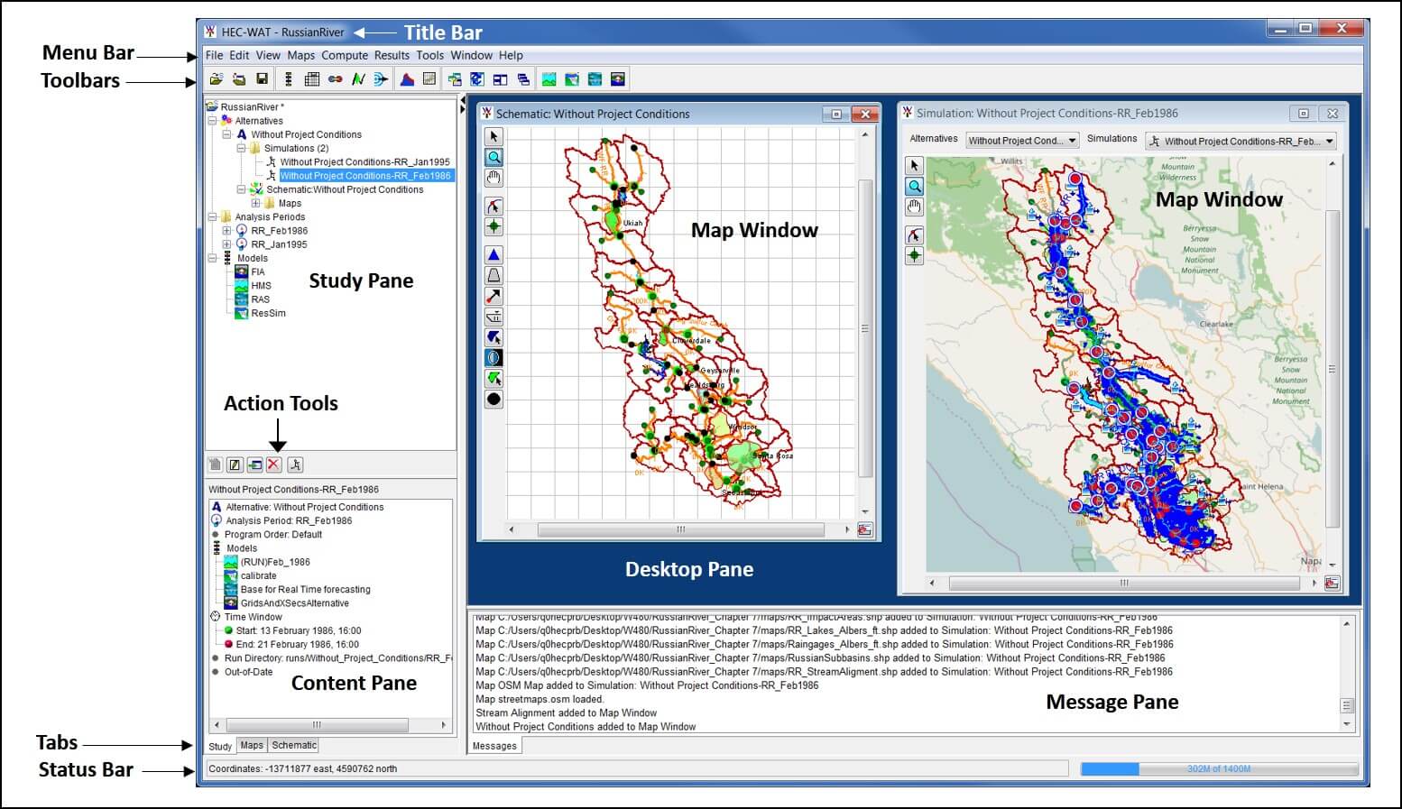
The HEC-WAT program provides a Graphical User Interface (GUI) that streamlines and integrates the water resource tools commonly applied by USACE district and division offices so that more efficient and coordinated
modeling and planning may be performed. The HEC-WAT framework uses the latest industry standards to provide a coordinated approach for a user to create and use a water resources study. The HEC-WAT GUI provides
dialogs for file management, data entry and editing, and viewing output. The interface provides for the following functions:
- File Management
- Data Entry, Importing, and Editing
- Tabulation and Graphical Displays of Results
- Reporting Features
Back to the top
Plug-Ins
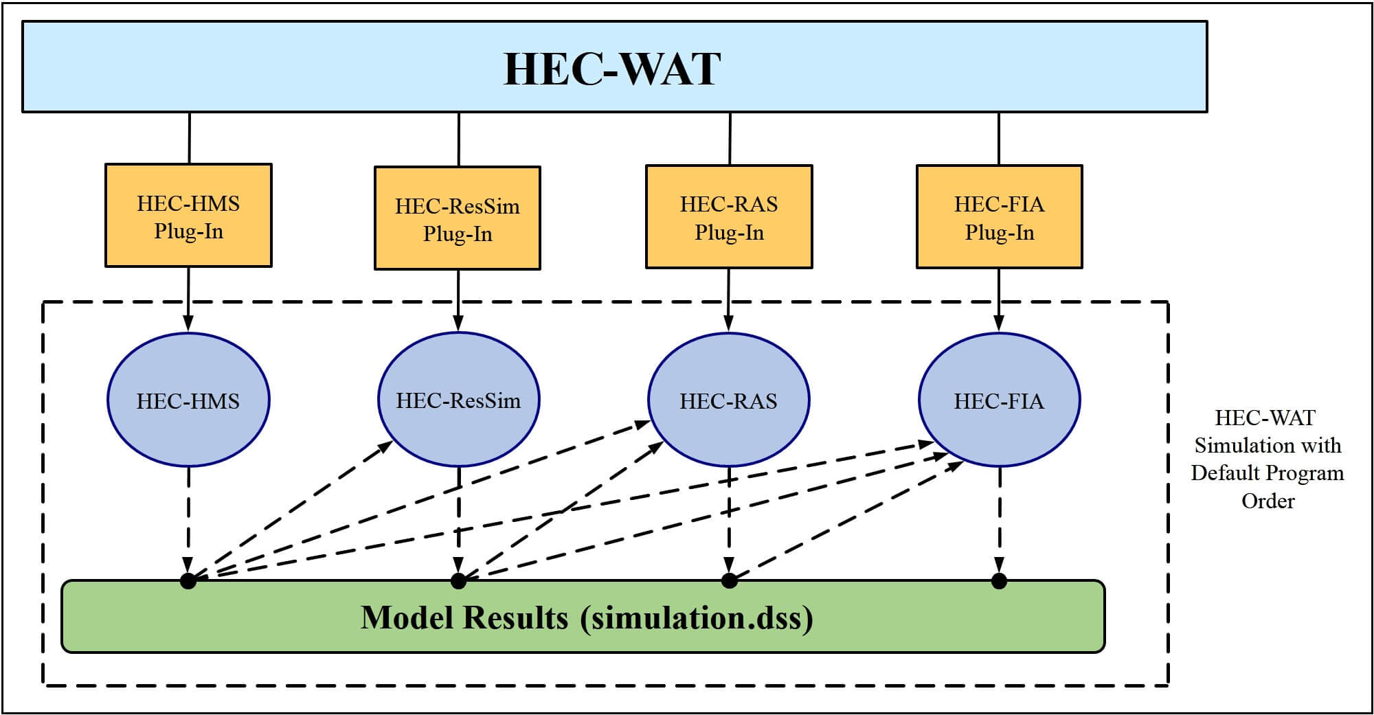
HEC-WAT does not replace existing software but rather forms a framework that allows existing software to work together. The integration of the individual pieces of software within the HEC-WAT framework is achieved
through the concept of a "plug-in". Plug-ins allow the individual pieces of software to integrate without requiring special code in HEC-WAT to support the individual pieces of software. The plug-in concept supports
additional plug-ins being developed for software that might be included in the HEC-WAT framework in the future. HEC-WAT provides the analysis framework and the individual pieces of software provides the technical
mechanics within the framework (i.e., editing, reporting capability, computational analyses, etc.). The individual pieces of software do not contain any HEC-WAT specific code. Further details about the plug-in
concept will be detailed in the HEC-WAT Technical Reference Manual (not available for Version 1.0).

Back to the top
HEC Software
The primary set of software includeed in the HEC-WAT framework is:
- HEC-HMS (Hydrologic Modeling System)
- HEC-RAS (River Analysis System)
- HEC-ResSim (Reservoir System Simulation)
- HEC-FIA (Flood Impact Aanalysis)
Back to the top
Visualization
HEC-WAT map windows are a way to graphically display stream alignments, schematics, alternatives, and simulations. The software allows the user to open and create various map windows in the interface. From HEC-WAT,
when a map window is opened, the map window is confined to the Desktop Pane of the HEC-WAT main window. When several map windows are open, the user can arrange the map windows, but viewing several map windows for
comparison and presentation becomes difficult. HEC-WAT allows the user to detach a map window from the Desktop Pane, and then move that map window outside of HEC-WAT. Detachable windows facilitate display during
presentations and make it easier to develop schematics within HEC-WAT.

Back to the top
Model Linking
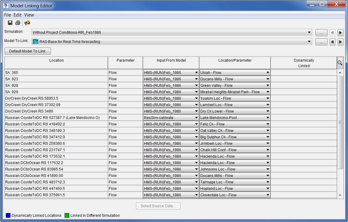
HEC-WAT has implemented a streamlined method to provide DSS data to the various pieces of software involved in a study. After a simulation has been created, the models need to communicate with each other. In
HEC-WAT this is accomplished by linking (DSS mapping) the models thru DSS records. In HEC-WAT, the Model Linking Editor provides an easy way to link models andg observed data, and provides a mechanism where the
linking only has to done once per alternative.

Back to the top
Flood Risk Management
The HEC-WAT framework also includes a flood risk analysis (FRA) compute option, which provides tools that will help a planner address the issues faced during a USACE planning study, and specifically addresses the
requirement for systems, watershed, and uncertainty analyses. The FRA compute builds on the HEC-WAT framework to provide a convenient method of implementing a Monte Carlo analysis across multiple models for flood
risk management. The HEC-WAT framework supports all the software that is needed to perform a system-wide analysis. The FRA compute option allows a user to perform plan formulation or system performance analyses
while incorporating risk and uncertainty capabilities.
Back to the top